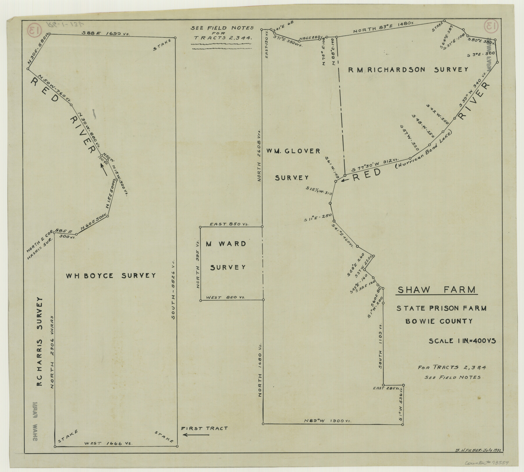
Shaw Farm, State Prison Farm, Bowie County
RG-1-13b
- 
                          Map/Doc
73559
 - 
                            Collection
General Map Collection
 - 
                            Counties
Bowie
 - 
                            Height x Width
16.1 x 17.9 inches
40.9 x 45.5 cm
 
Part of: General Map Collection
            Liberty County Sketch File 65


                                            Print $4.00                    
                                             -                         Digital $50.00                                    
                Liberty County Sketch File 65
1895
Size 11.0 x 8.7 inches
                                Map/Doc 30128
            
            Kent County Boundary File 5


                                            Print $6.00                    
                                             -                         Digital $50.00                                    
                Kent County Boundary File 5
Size 8.6 x 8.6 inches
                                Map/Doc 55865
            
            Map of Parker County


                                            Print $20.00                    
                                             -                         Digital $50.00                                    
                Map of Parker County
1871
Size 20.9 x 18.4 inches
                                Map/Doc 3942
            
            Location Through GC&SFRRCo., Runnels County, Texas


                                            Print $20.00                    
                                             -                         Digital $50.00                                    
                Location Through GC&SFRRCo., Runnels County, Texas
1898
Size 21.5 x 32.8 inches
                                Map/Doc 64509
            
            Brazoria County Sketch File 55


                                            Print $80.00                    
                                             -                         Digital $50.00                                    
                Brazoria County Sketch File 55
1899
Size 14.9 x 55.0 inches
                                Map/Doc 10327
            
            Calhoun County Sketch File 14


                                            Print $20.00                    
                                             -                         Digital $50.00                                    
                Calhoun County Sketch File 14
1852
Size 22.6 x 16.2 inches
                                Map/Doc 35980
            
            Webb County Rolled Sketch 56


                                            Print $20.00                    
                                             -                         Digital $50.00                                    
                Webb County Rolled Sketch 56
1945
Size 22.2 x 23.7 inches
                                Map/Doc 8208
            
            Outer Continental Shelf Leasing Maps (Louisiana Offshore Operations)


                                            Print $20.00                    
                                             -                         Digital $50.00                                    
                Outer Continental Shelf Leasing Maps (Louisiana Offshore Operations)
1954
Size 13.0 x 15.0 inches
                                Map/Doc 76111
            
            San Jacinto County Working Sketch 6


                                            Print $20.00                    
                                             -                         Digital $50.00                                    
                San Jacinto County Working Sketch 6
1934
Size 37.1 x 42.5 inches
                                Map/Doc 63719
            
            Dimmit County Sketch File 32


                                            Print $6.00                    
                                             -                         Digital $50.00                                    
                Dimmit County Sketch File 32
1886
Size 13.9 x 8.7 inches
                                Map/Doc 21148
            
            Map of Young County


                                            Print $20.00                    
                                             -                         Digital $50.00                                    
                Map of Young County
1897
Size 44.1 x 37.9 inches
                                Map/Doc 63140
            You may also like
            Coleman County Working Sketch 13


                                            Print $20.00                    
                                             -                         Digital $50.00                                    
                Coleman County Working Sketch 13
1952
Size 37.1 x 26.3 inches
                                Map/Doc 68079
            
            Red River County Working Sketch Graphic Index, Sheet 2 (Sketches 49 to Most Recent)


                                            Print $20.00                    
                                             -                         Digital $50.00                                    
                Red River County Working Sketch Graphic Index, Sheet 2 (Sketches 49 to Most Recent)
1934
Size 46.4 x 39.1 inches
                                Map/Doc 76681
            
            Montague County


                                            Print $20.00                    
                                             -                         Digital $50.00                                    
                Montague County
1924
Size 46.9 x 33.7 inches
                                Map/Doc 73243
            
            [Surveys along North and South Branches of Plum Creek, and vicinity]


                                            Print $2.00                    
                                             -                         Digital $50.00                                    
                [Surveys along North and South Branches of Plum Creek, and vicinity]
Size 11.0 x 8.6 inches
                                Map/Doc 91405
            
            Sutton County


                                            Print $40.00                    
                                             -                         Digital $50.00                                    
                Sutton County
1941
Size 40.9 x 54.3 inches
                                Map/Doc 77429
            
            Hardeman County Boundary File 38


                                            Print $70.00                    
                                             -                         Digital $50.00                                    
                Hardeman County Boundary File 38
Size 12.9 x 8.2 inches
                                Map/Doc 54400
            
            Proceedings of the International Boundary Commission, United States and Mexico, American Section, Elimination of Fifty-Seven Old Bancos Specifically Described in the Treaty of 1905


            Proceedings of the International Boundary Commission, United States and Mexico, American Section, Elimination of Fifty-Seven Old Bancos Specifically Described in the Treaty of 1905
Size 12.2 x 9.3 inches
                                Map/Doc 83124
            
            Houston County Sketch File 34


                                            Print $6.00                    
                                             -                         Digital $50.00                                    
                Houston County Sketch File 34
1914
Size 13.3 x 11.0 inches
                                Map/Doc 26811
            
            [Index of Texas Prison Farms]


                                            Print $20.00                    
                                             -                         Digital $50.00                                    
                [Index of Texas Prison Farms]
Size 31.1 x 23.1 inches
                                Map/Doc 62977
            
            Duval County Rolled Sketch 37


                                            Print $20.00                    
                                             -                         Digital $50.00                                    
                Duval County Rolled Sketch 37
1952
Size 29.2 x 24.6 inches
                                Map/Doc 5753
            
            Crockett County Rolled Sketch 88K


                                            Print $40.00                    
                                             -                         Digital $50.00                                    
                Crockett County Rolled Sketch 88K
1973
Size 43.0 x 57.4 inches
                                Map/Doc 8735
            
            Map of the Missouri, Kansas and Texas Railway and connecting lines


                                            Print $20.00                    
                                             -                         Digital $50.00                                    
                Map of the Missouri, Kansas and Texas Railway and connecting lines
1889
Size 17.7 x 32.1 inches
                                Map/Doc 95806