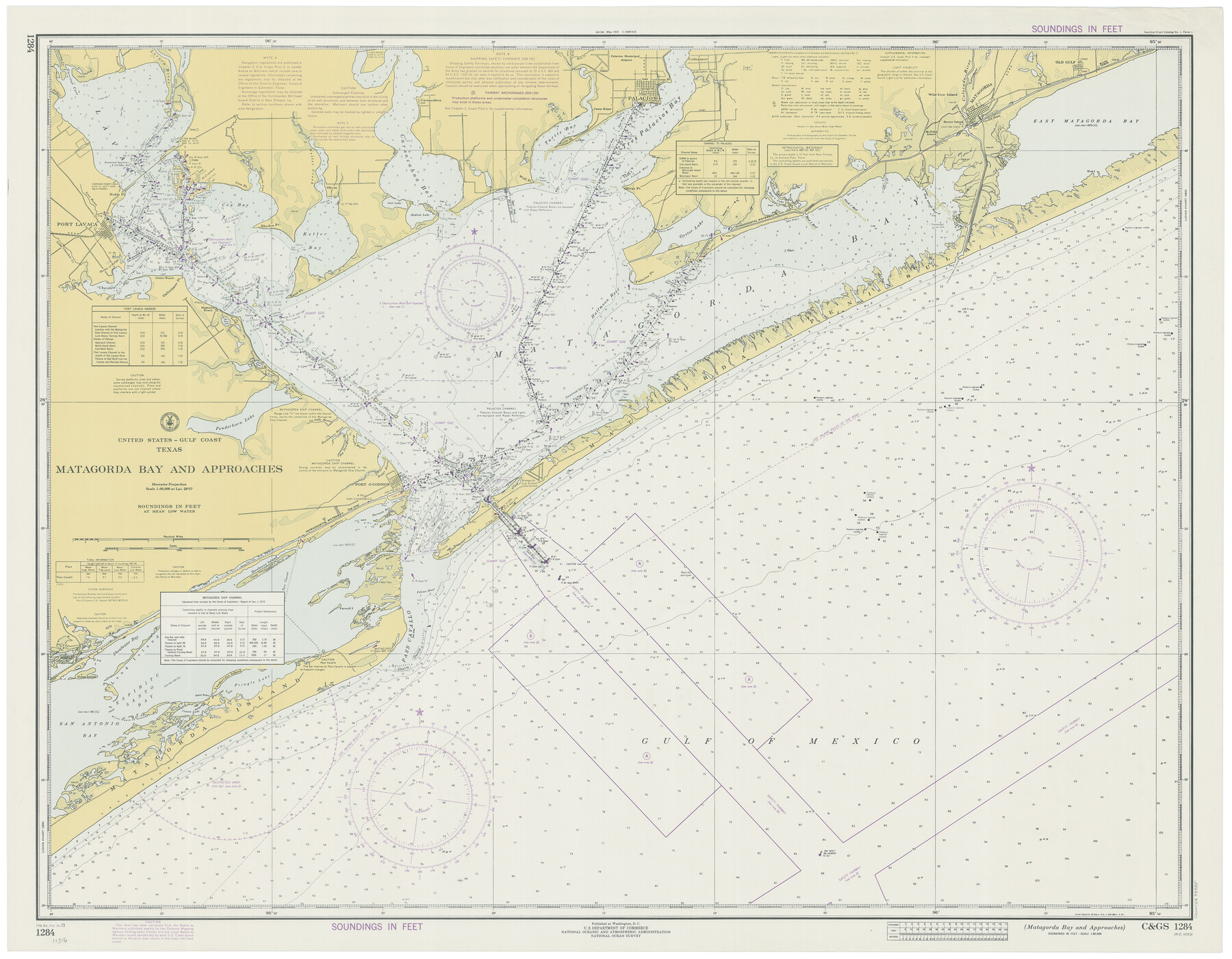
Matagorda Bay and Approaches
K-6-1284a
-
Map/Doc
73385
-
Collection
General Map Collection
-
Object Dates
2/24/1973 (Creation Date)
-
Counties
Matagorda Calhoun Victoria Jackson
-
Subjects
Nautical Charts
-
Height x Width
34.9 x 45.0 inches
88.7 x 114.3 cm
Part of: General Map Collection
Coleman County Working Sketch 22
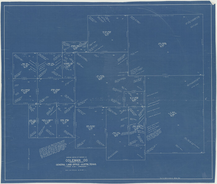
Print $20.00
- Digital $50.00
Coleman County Working Sketch 22
1953
Size 34.6 x 41.0 inches
Map/Doc 68088
Hopkins County Working Sketch 4

Print $20.00
- Digital $50.00
Hopkins County Working Sketch 4
1959
Size 23.3 x 30.9 inches
Map/Doc 66229
Coleman County

Print $40.00
- Digital $50.00
Coleman County
1945
Size 54.9 x 37.1 inches
Map/Doc 1803
Matagorda County Rolled Sketch PHL1

Print $20.00
- Digital $50.00
Matagorda County Rolled Sketch PHL1
Size 36.5 x 39.1 inches
Map/Doc 9477
Gillespie County Rolled Sketch O

Print $20.00
- Digital $50.00
Gillespie County Rolled Sketch O
1846
Size 42.6 x 20.0 inches
Map/Doc 6007

Glasscock County Working Sketch 16

Print $40.00
- Digital $50.00
Glasscock County Working Sketch 16
1984
Size 61.2 x 44.0 inches
Map/Doc 63189
Runnels County Working Sketch 18

Print $20.00
- Digital $50.00
Runnels County Working Sketch 18
1950
Size 27.9 x 31.2 inches
Map/Doc 63614
Polk County Sketch File 5

Print $2.00
- Digital $50.00
Polk County Sketch File 5
Size 8.0 x 7.0 inches
Map/Doc 34128
Jeff Davis County Sketch File 4

Print $42.00
- Digital $50.00
Jeff Davis County Sketch File 4
1889
Size 12.5 x 14.7 inches
Map/Doc 27893
Lavaca County Working Sketch 13

Print $20.00
- Digital $50.00
Lavaca County Working Sketch 13
1958
Size 23.5 x 29.1 inches
Map/Doc 70366
Brewster County Working Sketch 30

Print $40.00
- Digital $50.00
Brewster County Working Sketch 30
1942
Size 44.6 x 59.6 inches
Map/Doc 67564
You may also like
Hidalgo County Rolled Sketch 13

Print $20.00
- Digital $50.00
Hidalgo County Rolled Sketch 13
1960
Size 19.0 x 31.4 inches
Map/Doc 6212
Brazoria County Sketch File 38

Print $40.00
- Digital $50.00
Brazoria County Sketch File 38
1917
Size 17.1 x 14.5 inches
Map/Doc 15043
Upton County Working Sketch 30

Print $40.00
- Digital $50.00
Upton County Working Sketch 30
1956
Size 31.7 x 57.1 inches
Map/Doc 69526
Travis County Sketch File 17

Print $6.00
- Digital $50.00
Travis County Sketch File 17
Size 8.4 x 7.8 inches
Map/Doc 38314
Jefferson County Sketch File 39

Print $20.00
- Digital $50.00
Jefferson County Sketch File 39
Size 14.3 x 8.7 inches
Map/Doc 28218
Wilbarger County Sketch File 18

Print $12.00
- Digital $50.00
Wilbarger County Sketch File 18
1886
Size 14.3 x 8.8 inches
Map/Doc 40209
Panola County Working Sketch 26

Print $20.00
- Digital $50.00
Panola County Working Sketch 26
1958
Map/Doc 71435
Flight Mission No. DQN-5K, Frame 45, Calhoun County

Print $20.00
- Digital $50.00
Flight Mission No. DQN-5K, Frame 45, Calhoun County
1953
Size 18.4 x 22.1 inches
Map/Doc 84390
Ward County Working Sketch 15

Print $20.00
- Digital $50.00
Ward County Working Sketch 15
1947
Size 38.7 x 40.4 inches
Map/Doc 72321
Angelina County Working Sketch 44

Print $20.00
- Digital $50.00
Angelina County Working Sketch 44
1976
Size 22.2 x 25.7 inches
Map/Doc 67127
Maps of Gulf Intracoastal Waterway, Texas - Sabine River to the Rio Grande and connecting waterways including ship channels

Print $20.00
- Digital $50.00
Maps of Gulf Intracoastal Waterway, Texas - Sabine River to the Rio Grande and connecting waterways including ship channels
1966
Size 14.5 x 22.3 inches
Map/Doc 61921
Callahan County Working Sketch 11

Print $40.00
- Digital $50.00
Callahan County Working Sketch 11
1978
Size 43.0 x 48.1 inches
Map/Doc 67893