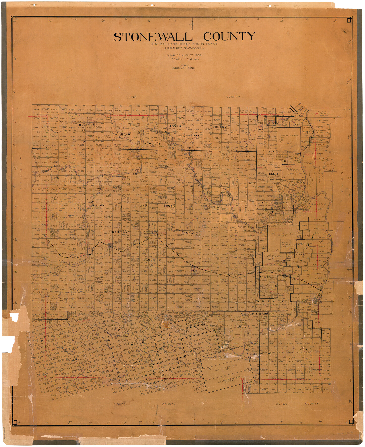
Stonewall County
-
Map/Doc
73295
-
Collection
General Map Collection
-
Object Dates
1933 (Creation Date)
-
People and Organizations
Texas General Land Office (Publisher)
John E. Shelton Jr. (Draftsman)
J.H. Walker (GLO Commissioner)
-
Counties
Stonewall
-
Subjects
County
-
Height x Width
47.6 x 39.5 inches
120.9 x 100.3 cm
-
Comments
Hand lettered.
Note on reverse side: "Hung September 30, 1933 John E. Shelton." -
Features
S&NW
South Nicholson's Creek
Gypsum Creek
Nicholson's Creek
Double Mountain Fork of Brazos River
Double Mountain
Rayner
Old Glory
Brandenburg
Mulberry Creek
Aspermont
Salt Creek
Peacock
Alluvia
Big Stinking Creek
Swenson
Salt Fork of Brazos River
Brazos River
Big South Croton Creek
Kiowa Peak
Mesquite Creek
Croton Creek
Part of: General Map Collection
Montague County Working Sketch 41

Print $40.00
- Digital $50.00
Montague County Working Sketch 41
1923
Size 43.0 x 66.1 inches
Map/Doc 65349
Hardin County Rolled Sketch 4

Print $20.00
- Digital $50.00
Hardin County Rolled Sketch 4
1938
Size 30.1 x 28.7 inches
Map/Doc 6077
Gray County Boundary File 3

Print $40.00
- Digital $50.00
Gray County Boundary File 3
Size 14.2 x 8.8 inches
Map/Doc 53854
Nueces County Sketch File 78

Print $72.00
- Digital $50.00
Nueces County Sketch File 78
1996
Size 11.1 x 8.4 inches
Map/Doc 33060
Coryell County Sketch File 5

Print $40.00
- Digital $50.00
Coryell County Sketch File 5
1858
Size 16.0 x 12.7 inches
Map/Doc 19345
Township 12 South Range 14 West and 15 West, South Western District, Louisiana

Print $20.00
- Digital $50.00
Township 12 South Range 14 West and 15 West, South Western District, Louisiana
1838
Size 19.5 x 24.5 inches
Map/Doc 65856
Comanche County Sketch File 19

Print $12.00
- Digital $50.00
Comanche County Sketch File 19
Size 13.0 x 8.0 inches
Map/Doc 19093
Harris County Sketch File 106

Print $80.00
- Digital $50.00
Harris County Sketch File 106
1995
Size 11.3 x 8.8 inches
Map/Doc 25975
Cameron County Rolled Sketch 25

Print $20.00
- Digital $50.00
Cameron County Rolled Sketch 25
1977
Size 17.5 x 27.5 inches
Map/Doc 5790
Supplemental Plat, T. 4S., R. 14W., Indian Meridian, Oklahoma

Print $4.00
- Digital $50.00
Supplemental Plat, T. 4S., R. 14W., Indian Meridian, Oklahoma
1926
Size 18.1 x 23.6 inches
Map/Doc 75149
Real County Working Sketch 61

Print $20.00
- Digital $50.00
Real County Working Sketch 61
1964
Size 37.9 x 44.5 inches
Map/Doc 71953
Gillespie County Boundary File 7a

Print $40.00
- Digital $50.00
Gillespie County Boundary File 7a
Size 8.7 x 51.2 inches
Map/Doc 53780
You may also like
Flight Mission No. BRA-16M, Frame 50, Jefferson County

Print $20.00
- Digital $50.00
Flight Mission No. BRA-16M, Frame 50, Jefferson County
1953
Size 18.5 x 22.5 inches
Map/Doc 85667
[Texas & Pacific Railway through Callahan County]
![64235, [Texas & Pacific Railway through Callahan County], General Map Collection](https://historictexasmaps.com/wmedia_w700/maps/64235.tif.jpg)
Print $20.00
- Digital $50.00
[Texas & Pacific Railway through Callahan County]
1918
Size 23.2 x 8.3 inches
Map/Doc 64235
King County Working Sketch 12

Print $20.00
- Digital $50.00
King County Working Sketch 12
1975
Size 42.6 x 28.4 inches
Map/Doc 70176
Hunt County Rolled Sketch 5

Print $20.00
- Digital $50.00
Hunt County Rolled Sketch 5
1956
Size 27.6 x 24.8 inches
Map/Doc 6270
The Republic County of Washington. May 24, 1838

Print $20.00
The Republic County of Washington. May 24, 1838
2020
Size 20.3 x 21.7 inches
Map/Doc 96303
Polk County Sketch File 25

Print $46.00
- Digital $50.00
Polk County Sketch File 25
Size 5.7 x 28.2 inches
Map/Doc 34176
Montague County Rolled Sketch 5

Print $20.00
- Digital $50.00
Montague County Rolled Sketch 5
Size 27.3 x 30.2 inches
Map/Doc 6789
West Part Presidio Co.

Print $20.00
- Digital $50.00
West Part Presidio Co.
1974
Size 40.5 x 31.4 inches
Map/Doc 77399

Georgetown and the City of Washington the Capital of the United States of America

Print $20.00
- Digital $50.00
Georgetown and the City of Washington the Capital of the United States of America
1856
Size 15.7 x 18.7 inches
Map/Doc 95359
Angelina County Sketch File 24

Print $8.00
- Digital $50.00
Angelina County Sketch File 24
1893
Size 8.9 x 5.6 inches
Map/Doc 13065
Johnson County Working Sketch 23

Print $20.00
- Digital $50.00
Johnson County Working Sketch 23
1997
Size 25.3 x 22.8 inches
Map/Doc 66636