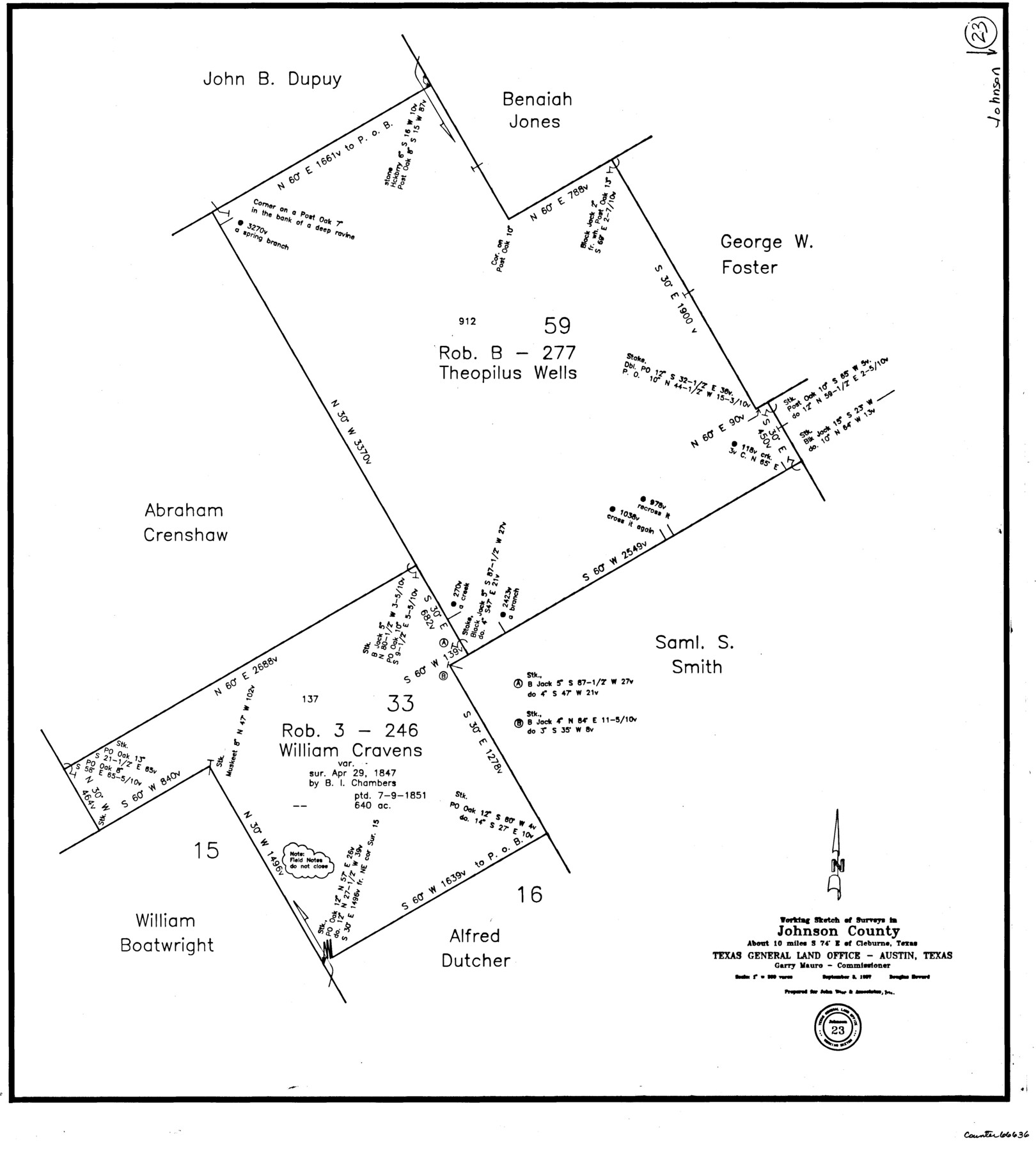
Johnson County Working Sketch 23
-
Map/Doc
66636
-
Collection
General Map Collection
-
Object Dates
9/3/1997 (Creation Date)
-
People and Organizations
Douglas Howard (Draftsman)
-
Counties
Johnson
-
Subjects
Surveying Working Sketch
-
Height x Width
25.3 x 22.8 inches
64.3 x 57.9 cm
-
Scale
1" = 300 varas
Part of: General Map Collection
Ellis County Sketch File 7

Print $40.00
- Digital $50.00
Ellis County Sketch File 7
1859
Size 12.2 x 15.6 inches
Map/Doc 21839
Hutchinson County Rolled Sketch 40

Print $20.00
- Digital $50.00
Hutchinson County Rolled Sketch 40
1981
Size 26.0 x 37.4 inches
Map/Doc 6300
Map of Wood County

Print $20.00
- Digital $50.00
Map of Wood County
1877
Size 16.8 x 17.1 inches
Map/Doc 4168
Flight Mission No. DQN-7K, Frame 93, Calhoun County

Print $20.00
- Digital $50.00
Flight Mission No. DQN-7K, Frame 93, Calhoun County
1953
Size 18.4 x 22.2 inches
Map/Doc 84484

Maps of Gulf Intracoastal Waterway, Texas - Sabine River to the Rio Grande and connecting waterways including ship channels

Print $20.00
- Digital $50.00
Maps of Gulf Intracoastal Waterway, Texas - Sabine River to the Rio Grande and connecting waterways including ship channels
1966
Size 14.5 x 20.8 inches
Map/Doc 61968
Eastland County Working Sketch 47

Print $20.00
- Digital $50.00
Eastland County Working Sketch 47
1981
Size 30.0 x 27.1 inches
Map/Doc 68828
Upshur County Sketch File 2a

Print $4.00
- Digital $50.00
Upshur County Sketch File 2a
Size 12.9 x 8.2 inches
Map/Doc 38734
Harris County Sketch File 9

Print $4.00
- Digital $50.00
Harris County Sketch File 9
1861
Size 6.7 x 7.3 inches
Map/Doc 25340
Cass County Rolled Sketch WDC

Print $20.00
- Digital $50.00
Cass County Rolled Sketch WDC
Size 20.8 x 32.9 inches
Map/Doc 5416
Sketch J No. 2 Showing the Progress of the Survey of San Francisco Bay and Vicinity Section X From 1850 to 1852

Print $20.00
- Digital $50.00
Sketch J No. 2 Showing the Progress of the Survey of San Francisco Bay and Vicinity Section X From 1850 to 1852
1852
Size 12.3 x 12.7 inches
Map/Doc 97229
Lee County Working Sketch 17

Print $20.00
- Digital $50.00
Lee County Working Sketch 17
1988
Size 31.8 x 32.2 inches
Map/Doc 70396
You may also like
Flight Mission No. BRE-2P, Frame 21, Nueces County

Print $20.00
- Digital $50.00
Flight Mission No. BRE-2P, Frame 21, Nueces County
1956
Size 18.5 x 22.3 inches
Map/Doc 86730
Uvalde County Working Sketch 61

Print $20.00
- Digital $50.00
Uvalde County Working Sketch 61
1978
Size 40.4 x 37.4 inches
Map/Doc 72131
Flight Mission No. DAG-21K, Frame 133, Matagorda County

Print $20.00
- Digital $50.00
Flight Mission No. DAG-21K, Frame 133, Matagorda County
1952
Size 18.6 x 22.4 inches
Map/Doc 86459
Military Reconstruction Districts

Military Reconstruction Districts
2024
Size 8.5 x 11.0 inches
Map/Doc 97345
Outer Continental Shelf Leasing Maps (Louisiana Offshore Operations)

Print $20.00
- Digital $50.00
Outer Continental Shelf Leasing Maps (Louisiana Offshore Operations)
1959
Size 13.7 x 17.4 inches
Map/Doc 76116
Bailey County Rolled Sketch 6

Print $20.00
- Digital $50.00
Bailey County Rolled Sketch 6
Size 17.4 x 12.9 inches
Map/Doc 5111
Potter County Sketch

Print $20.00
- Digital $50.00
Potter County Sketch
Size 16.3 x 20.9 inches
Map/Doc 91808
Harris County Boundary File 39 (18)

Print $4.00
- Digital $50.00
Harris County Boundary File 39 (18)
Size 12.7 x 7.9 inches
Map/Doc 54359

Flight Mission No. CGI-4N, Frame 161, Cameron County

Print $20.00
- Digital $50.00
Flight Mission No. CGI-4N, Frame 161, Cameron County
1955
Size 18.7 x 22.4 inches
Map/Doc 84669
Mason County Working Sketch 13

Print $20.00
- Digital $50.00
Mason County Working Sketch 13
1954
Size 20.0 x 29.9 inches
Map/Doc 70849
Webb County Sketch File 53

Print $20.00
- Digital $50.00
Webb County Sketch File 53
1939
Size 18.7 x 14.5 inches
Map/Doc 12649