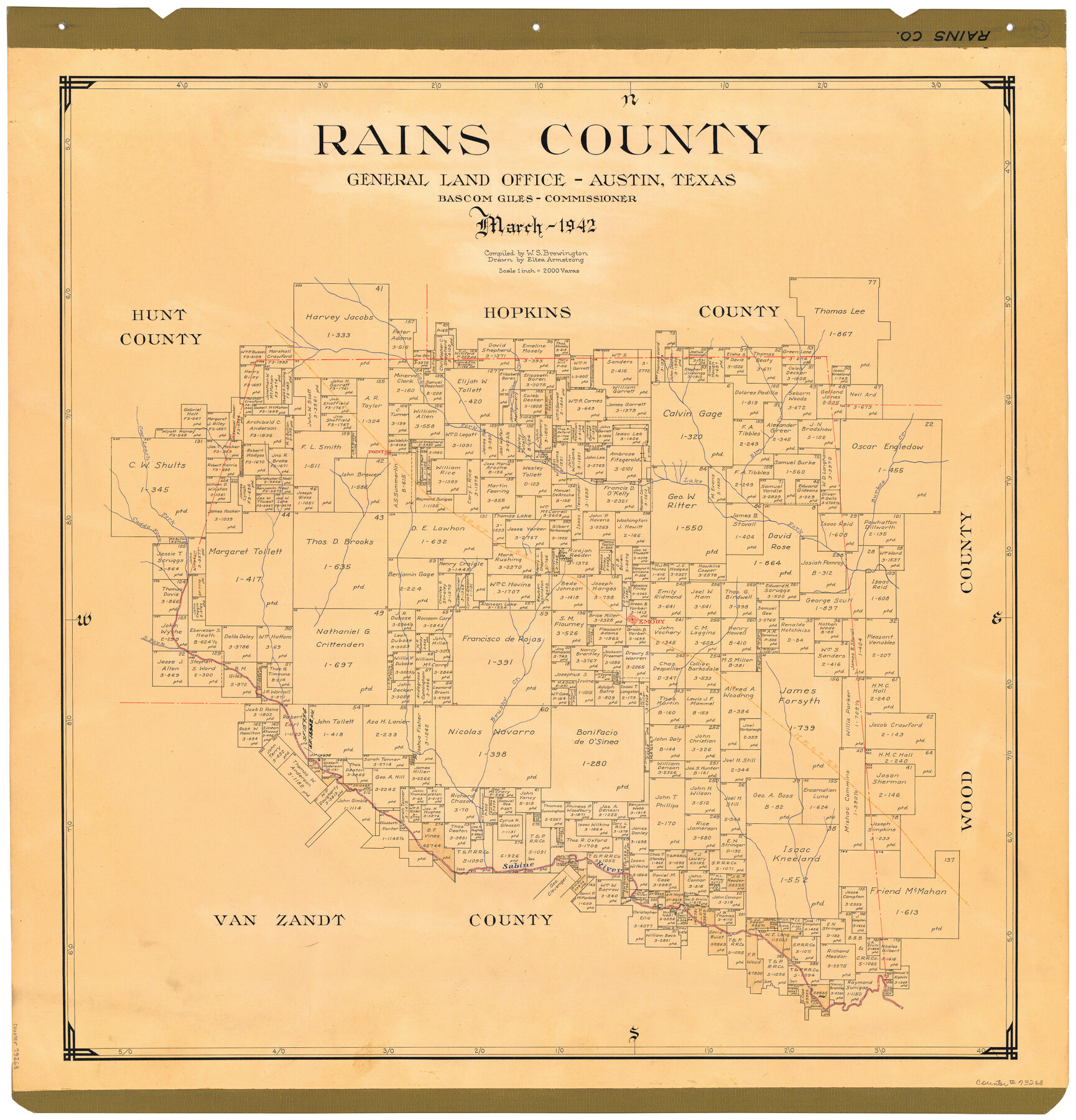
Rains County
-
Map/Doc
73268
-
Collection
General Map Collection
-
Object Dates
1942 (Creation Date)
-
People and Organizations
Texas General Land Office (Publisher)
Eltea Armstrong (Draftsman)
Bascom Giles (GLO Commissioner)
W. S. Brewington (Compiler)
-
Counties
Rains
-
Subjects
County
-
Height x Width
30.0 x 28.8 inches
76.2 x 73.2 cm
-
Comments
Hand lettered.
Note on reverse side: "Replaced [on sticks] by copy June 20, 1946." -
Features
Burkes Creek
Emory
South Fork of Sabine River
Sabine River
Brushy Creek
Elm Creek
Turkey Creek
Lake Fork [Creek]
Point
Cow Leach Fork [of Sabine River]
Caddo Fork [of Sabine River]
MK&T
Part of: General Map Collection
Madison County Rolled Sketch 1A

Print $20.00
- Digital $50.00
Madison County Rolled Sketch 1A
1966
Size 36.1 x 45.5 inches
Map/Doc 9486
Floyd County Rolled Sketch 10

Print $20.00
- Digital $50.00
Floyd County Rolled Sketch 10
1953
Size 37.8 x 25.0 inches
Map/Doc 5883
Angelina County Sketch File 18

Print $4.00
- Digital $50.00
Angelina County Sketch File 18
Size 8.6 x 3.9 inches
Map/Doc 13028
Lee County Working Sketch 3

Print $20.00
- Digital $50.00
Lee County Working Sketch 3
1968
Size 37.9 x 37.3 inches
Map/Doc 70382
Uvalde County Boundary File 1a

Print $12.00
- Digital $50.00
Uvalde County Boundary File 1a
Size 14.5 x 8.9 inches
Map/Doc 59551
Kleberg County Rolled Sketch 10-8

Print $20.00
- Digital $50.00
Kleberg County Rolled Sketch 10-8
1951
Size 36.6 x 33.7 inches
Map/Doc 9370
Crockett County Working Sketch 62

Print $40.00
- Digital $50.00
Crockett County Working Sketch 62
1956
Size 121.8 x 37.1 inches
Map/Doc 68395
King County Sketch File 10

Print $24.00
- Digital $50.00
King County Sketch File 10
1902
Size 14.2 x 8.7 inches
Map/Doc 29083
Baylor County Rolled Sketch 9

Print $20.00
- Digital $50.00
Baylor County Rolled Sketch 9
1892
Size 18.2 x 26.1 inches
Map/Doc 5125
Edwards County Working Sketch 67

Print $20.00
- Digital $50.00
Edwards County Working Sketch 67
1957
Size 38.3 x 44.2 inches
Map/Doc 68943
Edwards County Working Sketch 53

Print $40.00
- Digital $50.00
Edwards County Working Sketch 53
1951
Size 40.8 x 48.5 inches
Map/Doc 68929
Brewster County Rolled Sketch 59D

Print $20.00
- Digital $50.00
Brewster County Rolled Sketch 59D
Size 33.3 x 47.3 inches
Map/Doc 5231
You may also like
Parker County

Print $20.00
- Digital $50.00
Parker County
1942
Size 45.7 x 37.8 inches
Map/Doc 66972
General Highway Map, San Jacinto County, Texas

Print $20.00
General Highway Map, San Jacinto County, Texas
1940
Size 24.9 x 18.4 inches
Map/Doc 79236
[Pacific & Santa Fe Railroad through Fort Stockton]
![64770, [Pacific & Santa Fe Railroad through Fort Stockton], General Map Collection](https://historictexasmaps.com/wmedia_w700/maps/64770.tif.jpg)
Print $20.00
- Digital $50.00
[Pacific & Santa Fe Railroad through Fort Stockton]
Size 18.4 x 20.5 inches
Map/Doc 64770
Frio County Sketch File 16

Print $8.00
- Digital $50.00
Frio County Sketch File 16
1949
Size 11.3 x 8.8 inches
Map/Doc 23148
Val Verde Co.

Print $20.00
- Digital $50.00
Val Verde Co.
1908
Size 40.9 x 38.5 inches
Map/Doc 63101
Val Verde Co.

Print $20.00
- Digital $50.00
Val Verde Co.
1908
Size 40.5 x 38.4 inches
Map/Doc 63099
[T.&P. Blocks 57 and 58, South to PSL Block 53]
![89763, [T.&P. Blocks 57 and 58, South to PSL Block 53], Twichell Survey Records](https://historictexasmaps.com/wmedia_w700/maps/89763-1.tif.jpg)
Print $40.00
- Digital $50.00
[T.&P. Blocks 57 and 58, South to PSL Block 53]
Size 30.5 x 68.7 inches
Map/Doc 89763
Stonewall County Sketch File 25

Print $7.00
- Digital $50.00
Stonewall County Sketch File 25
1952
Size 26.7 x 43.3 inches
Map/Doc 10375
Flight Mission No. DAG-23K, Frame 16, Matagorda County

Print $20.00
- Digital $50.00
Flight Mission No. DAG-23K, Frame 16, Matagorda County
1953
Size 18.5 x 22.2 inches
Map/Doc 86478
[Leagues 1, 2, 281, 282, 284, and 285]
![92563, [Leagues 1, 2, 281, 282, 284, and 285], Twichell Survey Records](https://historictexasmaps.com/wmedia_w700/maps/92563-1.tif.jpg)
Print $20.00
- Digital $50.00
[Leagues 1, 2, 281, 282, 284, and 285]
Size 23.8 x 19.3 inches
Map/Doc 92563
Moore County Sketch File 5

Print $22.00
- Digital $50.00
Moore County Sketch File 5
Size 9.0 x 12.6 inches
Map/Doc 31937
Cass County Sketch File 4

Print $6.00
- Digital $50.00
Cass County Sketch File 4
1853
Size 8.2 x 11.2 inches
Map/Doc 17398