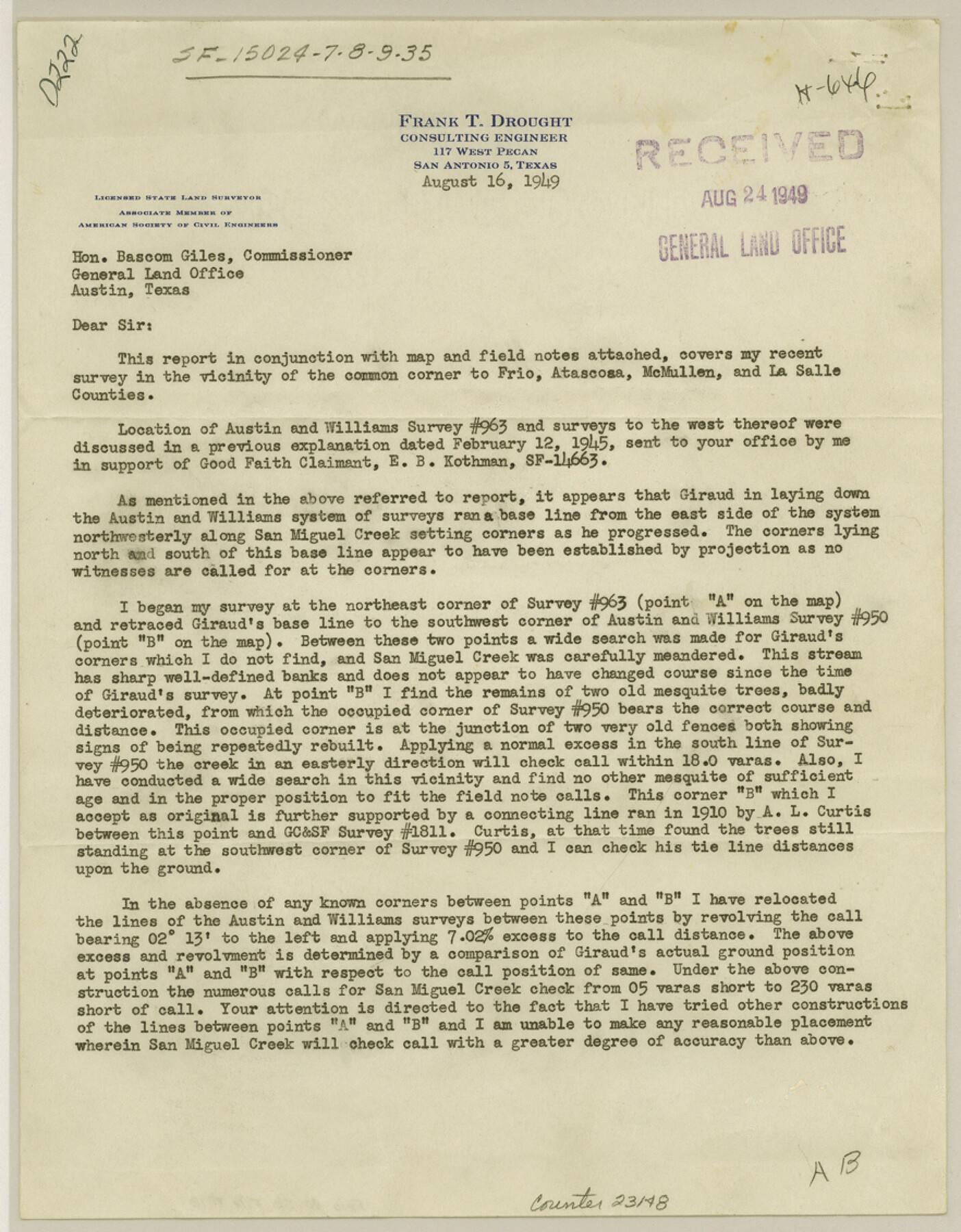
Frio County Sketch File 16
[Surveyor's report on SF-15024, SF-15027, SF-15028, SF-15029 and SF-15035]
- 
                          Map/Doc
23148
 - 
                            Collection
General Map Collection
 - 
                            Object Dates
1949/8/16 (Creation Date)
1949/9/3 (File Date)
1875 (Survey Date)
1880 (Survey Date)
 - 
                            People and Organizations
Frank T. Drought (Surveyor/Engineer)
Giraud (Surveyor/Engineer)
Enoch Moore (Surveyor/Engineer)
W.H. Fountain (Surveyor/Engineer)
 - 
                            Counties
Frio Atascosa McMullen La Salle
 - 
                            Subjects
Surveying Sketch File
 - 
                            Height x Width
11.3 x 8.8 inches
28.7 x 22.4 cm
 - 
                            Medium
paper, print
 - 
                            Features
San Miguel Creek
 
Part of: General Map Collection
            Flight Mission No. DAG-21K, Frame 38, Matagorda County


                                            Print $20.00                    
                                             -                         Digital $50.00                                    
                Flight Mission No. DAG-21K, Frame 38, Matagorda County
1952
Size 18.6 x 22.3 inches
                                Map/Doc 86405
            
            Bee County Sketch File 25


                                            Print $4.00                    
                                             -                         Digital $50.00                                    
                Bee County Sketch File 25
1880
Size 11.0 x 8.2 inches
                                Map/Doc 14326
            
            Collin County Sketch File 15


                                            Print $4.00                    
                                             -                         Digital $50.00                                    
                Collin County Sketch File 15
1873
Size 10.0 x 8.0 inches
                                Map/Doc 18880
            
            Brazos River, Brazos River Sheet 2


                                            Print $20.00                    
                                             -                         Digital $50.00                                    
                Brazos River, Brazos River Sheet 2
1926
Size 22.3 x 29.4 inches
                                Map/Doc 69666
            
            Flight Mission No. DQO-8K, Frame 55, Galveston County


                                            Print $20.00                    
                                             -                         Digital $50.00                                    
                Flight Mission No. DQO-8K, Frame 55, Galveston County
1952
Size 18.7 x 22.5 inches
                                Map/Doc 85162
            
            Midland County


                                            Print $20.00                    
                                             -                         Digital $50.00                                    
                Midland County
1896
Size 21.5 x 20.0 inches
                                Map/Doc 3877
            
            Polk County Boundary File 70


                                            Print $12.00                    
                                             -                         Digital $50.00                                    
                Polk County Boundary File 70
Size 8.2 x 3.6 inches
                                Map/Doc 57930
            
            Flight Mission No. DQN-2K, Frame 188, Calhoun County


                                            Print $20.00                    
                                             -                         Digital $50.00                                    
                Flight Mission No. DQN-2K, Frame 188, Calhoun County
1953
Size 18.6 x 22.3 inches
                                Map/Doc 84329
            
            Upton County Working Sketch 8


                                            Print $20.00                    
                                             -                         Digital $50.00                                    
                Upton County Working Sketch 8
1916
Size 21.9 x 16.8 inches
                                Map/Doc 69504
            
            King County Boundary File 5


                                            Print $12.00                    
                                             -                         Digital $50.00                                    
                King County Boundary File 5
Size 14.2 x 8.8 inches
                                Map/Doc 64916
            
            Flight Mission No. DQO-2K, Frame 87, Galveston County


                                            Print $20.00                    
                                             -                         Digital $50.00                                    
                Flight Mission No. DQO-2K, Frame 87, Galveston County
1952
Size 18.7 x 22.5 inches
                                Map/Doc 85014
            You may also like
            Edwards County Rolled Sketch 37


                                            Print $20.00                    
                                             -                         Digital $50.00                                    
                Edwards County Rolled Sketch 37
2018
Size 23.3 x 30.2 inches
                                Map/Doc 94459
            
            Crane County Sketch File 3a


                                            Print $20.00                    
                                             -                         Digital $50.00                                    
                Crane County Sketch File 3a
Size 20.8 x 13.0 inches
                                Map/Doc 11205
            
            Rand, McNally & Co.'s Texas


                                            Print $20.00                    
                                             -                         Digital $50.00                                    
                Rand, McNally & Co.'s Texas
1902
Size 21.3 x 28.4 inches
                                Map/Doc 95886
            
            Wise County Working Sketch 5


                                            Print $20.00                    
                                             -                         Digital $50.00                                    
                Wise County Working Sketch 5
1948
Size 25.7 x 23.4 inches
                                Map/Doc 72619
            
            Flight Mission No. CRE-1R, Frame 132, Jackson County


                                            Print $20.00                    
                                             -                         Digital $50.00                                    
                Flight Mission No. CRE-1R, Frame 132, Jackson County
1956
Size 16.2 x 16.0 inches
                                Map/Doc 85340
            
            A Map of the United States of Mexico as organized and defined by the several Acts of the Congress of that Republic


                                            Print $20.00                    
                                             -                         Digital $50.00                                    
                A Map of the United States of Mexico as organized and defined by the several Acts of the Congress of that Republic
1847
Size 24.3 x 30.6 inches
                                Map/Doc 93876
            
            [St. L. S-W. Ry. of Texas Map of Lufkin Branch in Cherokee County Texas]


                                            Print $40.00                    
                                             -                         Digital $50.00                                    
                [St. L. S-W. Ry. of Texas Map of Lufkin Branch in Cherokee County Texas]
1912
Size 22.8 x 121.4 inches
                                Map/Doc 64017
            
            Runnels County Sketch File H


                                            Print $4.00                    
                                    
                Runnels County Sketch File H
1890
Size 14.3 x 8.8 inches
                                Map/Doc 35450
            
            Floyd County Working Sketch 7


                                            Print $20.00                    
                                             -                         Digital $50.00                                    
                Floyd County Working Sketch 7
1922
Size 14.4 x 17.9 inches
                                Map/Doc 69186