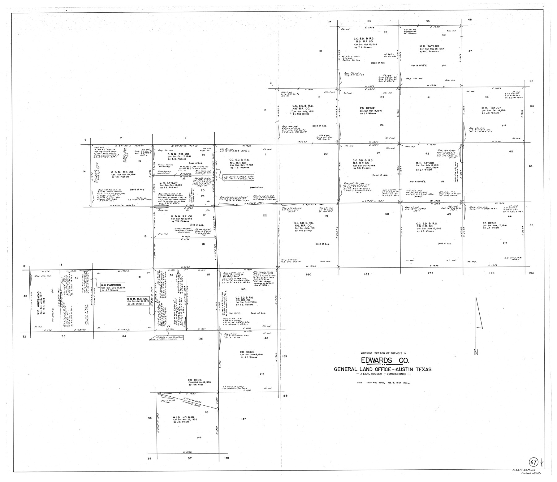
Edwards County Working Sketch 67
-
Map/Doc
68943
-
Collection
General Map Collection
-
Object Dates
2/18/1957 (Creation Date)
-
Counties
Edwards
-
Subjects
Surveying Working Sketch
-
Height x Width
38.3 x 44.2 inches
97.3 x 112.3 cm
-
Scale
1" = 400 varas
Part of: General Map Collection
Navarro County Working Sketch 6

Print $20.00
- Digital $50.00
Navarro County Working Sketch 6
1950
Size 25.3 x 33.7 inches
Map/Doc 71236
Current Miscellaneous File 57

Print $4.00
- Digital $50.00
Current Miscellaneous File 57
1955
Size 11.8 x 9.2 inches
Map/Doc 74050
Coke County Working Sketch 5

Print $20.00
- Digital $50.00
Coke County Working Sketch 5
1913
Size 24.1 x 27.9 inches
Map/Doc 68042
Flight Mission No. CGI-3N, Frame 186, Cameron County

Print $20.00
- Digital $50.00
Flight Mission No. CGI-3N, Frame 186, Cameron County
1954
Size 18.6 x 22.3 inches
Map/Doc 84650
Flight Mission No. DIX-7P, Frame 21, Aransas County

Print $20.00
- Digital $50.00
Flight Mission No. DIX-7P, Frame 21, Aransas County
1956
Size 18.8 x 22.6 inches
Map/Doc 83873
Borden County Sketch File 4a

Print $40.00
- Digital $50.00
Borden County Sketch File 4a
Size 27.1 x 18.1 inches
Map/Doc 10934
Tyler County Sketch File 1b

Print $8.00
- Digital $50.00
Tyler County Sketch File 1b
1900
Size 7.5 x 3.2 inches
Map/Doc 38611
Burnet County Sketch File 43

Print $8.00
- Digital $50.00
Burnet County Sketch File 43
1856
Size 9.4 x 6.0 inches
Map/Doc 16763
Blanco County Rolled Sketch 13

Print $20.00
- Digital $50.00
Blanco County Rolled Sketch 13
Size 14.2 x 28.9 inches
Map/Doc 5149
Travels to the source of the Missouri River and across the American Continent to the Pacific Ocean - Vol. 3

Travels to the source of the Missouri River and across the American Continent to the Pacific Ocean - Vol. 3
1815
Map/Doc 97414
Pecos County Sketch File 46

Print $26.00
- Digital $50.00
Pecos County Sketch File 46
1921
Size 11.4 x 8.9 inches
Map/Doc 33746
Galveston County Sketch File 1a

Print $4.00
- Digital $50.00
Galveston County Sketch File 1a
1847
Size 10.2 x 8.9 inches
Map/Doc 23344
You may also like
Map No. 1 - Rio Bravo del Norte section of boundary between the United States & Mexico agreed upon by the Joint Commission under the Treaty of Guadalupe Hidalgo

Print $20.00
- Digital $50.00
Map No. 1 - Rio Bravo del Norte section of boundary between the United States & Mexico agreed upon by the Joint Commission under the Treaty of Guadalupe Hidalgo
1852
Size 18.4 x 27.0 inches
Map/Doc 72864
Lee County Working Sketch 17

Print $20.00
- Digital $50.00
Lee County Working Sketch 17
1988
Size 31.8 x 32.2 inches
Map/Doc 70396
Harris County Working Sketch 111

Print $20.00
- Digital $50.00
Harris County Working Sketch 111
1982
Size 21.7 x 16.0 inches
Map/Doc 66003
Cameron County

Print $20.00
- Digital $50.00
Cameron County
1976
Size 30.9 x 38.1 inches
Map/Doc 77230
Coryell County Working Sketch 26

Print $20.00
- Digital $50.00
Coryell County Working Sketch 26
1988
Size 30.7 x 30.6 inches
Map/Doc 68233
Taylor County Working Sketch 13

Print $20.00
- Digital $50.00
Taylor County Working Sketch 13
1956
Size 16.3 x 28.9 inches
Map/Doc 69623
Kerr County Rolled Sketch 22

Print $20.00
- Digital $50.00
Kerr County Rolled Sketch 22
1959
Size 35.7 x 30.2 inches
Map/Doc 9349
The Republic County of Refugio. Proposed, Late Fall 1837

Print $20.00
The Republic County of Refugio. Proposed, Late Fall 1837
2020
Size 22.3 x 21.6 inches
Map/Doc 96256
Hutchinson County Rolled Sketch 41

Print $40.00
- Digital $50.00
Hutchinson County Rolled Sketch 41
1989
Size 43.3 x 144.5 inches
Map/Doc 9249
Dimmit County Rolled Sketch 21

Print $20.00
- Digital $50.00
Dimmit County Rolled Sketch 21
2013
Size 25.5 x 22.5 inches
Map/Doc 93488
Polk County Working Sketch 6

Print $20.00
- Digital $50.00
Polk County Working Sketch 6
1933
Size 22.8 x 32.7 inches
Map/Doc 71621
Flight Mission No. DQO-7K, Frame 108, Galveston County

Print $20.00
- Digital $50.00
Flight Mission No. DQO-7K, Frame 108, Galveston County
1952
Size 18.7 x 22.5 inches
Map/Doc 85123