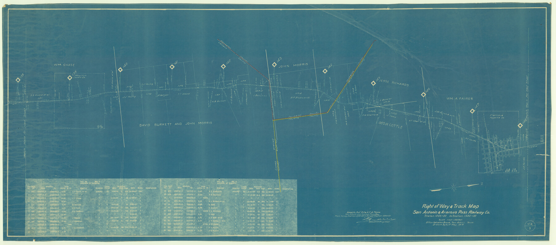
Right of Way & Track Map, San Antonio & Aransas Pass Railway Co.
Station 1056+00 to Station 1584+00
Z-2-55
-
Map/Doc
64215
-
Collection
General Map Collection
-
Object Dates
1919 (Creation Date)
-
People and Organizations
Office Valuation Board (Publisher)
-
Counties
Fayette Lavaca Gonzales
-
Subjects
Railroads
-
Height x Width
25.0 x 56.7 inches
63.5 x 144.0 cm
-
Medium
blueprint/diazo
-
Scale
1 inch = 1000 feet
-
Comments
See counters 64213 through 64218 for all pages of map.
-
Features
SA&AP
Moulton
Flatonia
Part of: General Map Collection
Liberty County Sketch File 29

Print $40.00
- Digital $50.00
Liberty County Sketch File 29
1888
Size 14.9 x 14.9 inches
Map/Doc 29955
Crane County Sketch File 29

Print $6.00
- Digital $50.00
Crane County Sketch File 29
1930
Size 12.8 x 10.4 inches
Map/Doc 19608
Bailey County Working Sketch 6

Print $20.00
- Digital $50.00
Bailey County Working Sketch 6
1966
Size 37.0 x 34.5 inches
Map/Doc 67593
Bosque County Rolled Sketch 2

Print $20.00
- Digital $50.00
Bosque County Rolled Sketch 2
Size 30.2 x 18.1 inches
Map/Doc 5160
Brewster County Sketch File NS-13

Print $4.00
- Digital $50.00
Brewster County Sketch File NS-13
1955
Size 11.1 x 8.8 inches
Map/Doc 16220
Map of Cottle County

Print $20.00
- Digital $50.00
Map of Cottle County
1893
Size 23.1 x 19.4 inches
Map/Doc 3451
Upton County Sketch File 13

Print $20.00
- Digital $50.00
Upton County Sketch File 13
1926
Size 34.3 x 37.3 inches
Map/Doc 10414
Polk County Working Sketch 6

Print $20.00
- Digital $50.00
Polk County Working Sketch 6
1933
Size 22.8 x 32.7 inches
Map/Doc 71621
Ward County Working Sketch 12

Print $20.00
- Digital $50.00
Ward County Working Sketch 12
1947
Size 23.4 x 22.7 inches
Map/Doc 72318
Ward County Working Sketch 24

Print $20.00
- Digital $50.00
Ward County Working Sketch 24
1955
Size 41.7 x 37.0 inches
Map/Doc 72330
Sabine County Sketch File 9

Print $6.00
Sabine County Sketch File 9
1912
Size 12.7 x 8.0 inches
Map/Doc 35624
Crosby County Sketch File 11

Print $64.00
- Digital $50.00
Crosby County Sketch File 11
Size 13.8 x 8.9 inches
Map/Doc 20017
You may also like
Map of Smith County

Print $20.00
- Digital $50.00
Map of Smith County
1872
Size 19.2 x 19.3 inches
Map/Doc 4039
Pecos County Working Sketch 1

Print $20.00
- Digital $50.00
Pecos County Working Sketch 1
Size 16.0 x 13.0 inches
Map/Doc 71471
Bastrop County

Print $20.00
- Digital $50.00
Bastrop County
1883
Size 25.9 x 25.2 inches
Map/Doc 3276
Flight Mission No. CLL-1N, Frame 76, Willacy County

Print $20.00
- Digital $50.00
Flight Mission No. CLL-1N, Frame 76, Willacy County
1954
Size 18.3 x 22.0 inches
Map/Doc 87022
Reeves County Working Sketch 37

Print $40.00
- Digital $50.00
Reeves County Working Sketch 37
1971
Size 57.7 x 36.7 inches
Map/Doc 63480
Angelina County

Print $40.00
- Digital $50.00
Angelina County
1899
Size 38.9 x 49.9 inches
Map/Doc 4873
Map of Orange County

Print $20.00
- Digital $50.00
Map of Orange County
1880
Size 15.2 x 19.2 inches
Map/Doc 3930
Zapata County Rolled Sketch 20

Print $40.00
- Digital $50.00
Zapata County Rolled Sketch 20
1956
Size 21.2 x 49.1 inches
Map/Doc 10171
Presidio County Sketch File 67

Print $6.00
- Digital $50.00
Presidio County Sketch File 67
1940
Size 11.3 x 8.9 inches
Map/Doc 34659
Jefferson County Rolled Sketch 33

Print $20.00
- Digital $50.00
Jefferson County Rolled Sketch 33
1956
Size 46.8 x 27.5 inches
Map/Doc 6393
Webb County Sketch File 70

Print $26.00
- Digital $50.00
Webb County Sketch File 70
Size 11.4 x 8.9 inches
Map/Doc 39875
Jones County Sketch File 21

Print $56.00
- Digital $50.00
Jones County Sketch File 21
2010
Map/Doc 93292