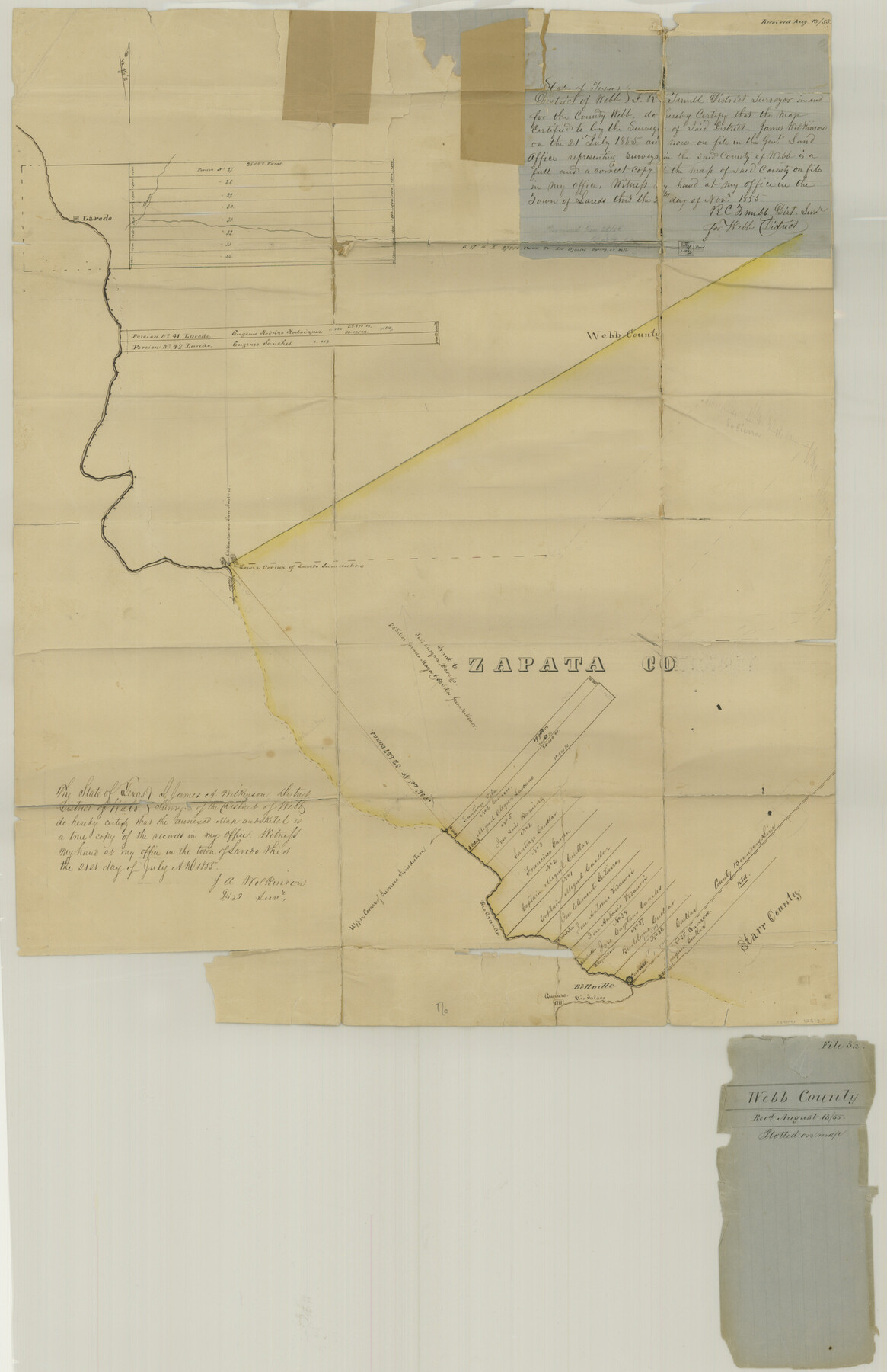
Webb County Sketch File 3a
[Sketch of porciones along the Rio Grande in Webb and Zapata Counties]
-
Map/Doc
12613
-
Collection
General Map Collection
-
Object Dates
7/21/1855 (Creation Date)
8/13/1855 (File Date)
-
People and Organizations
James A. Wilkinson (Surveyor/Engineer)
-
Counties
Webb Zapata
-
Subjects
Surveying Sketch File
-
Height x Width
32.1 x 20.8 inches
81.5 x 52.8 cm
-
Medium
paper, manuscript
-
Features
Laredo
Coralitos
Rio Grande
Bellville
Carriso
Part of: General Map Collection
Flight Mission No. CGI-1N, Frame 216, Cameron County

Print $20.00
- Digital $50.00
Flight Mission No. CGI-1N, Frame 216, Cameron County
1955
Size 18.5 x 22.2 inches
Map/Doc 84525
Belton and Stillhouse Hollow Reservoirs (Verso)

Belton and Stillhouse Hollow Reservoirs (Verso)
1972
Size 29.3 x 22.7 inches
Map/Doc 94173
Polk County Sketch File 29a

Print $4.00
- Digital $50.00
Polk County Sketch File 29a
Size 12.1 x 8.2 inches
Map/Doc 34202
Harris County Rolled Sketch 81

Print $28.00
- Digital $50.00
Harris County Rolled Sketch 81
1956
Size 31.1 x 22.2 inches
Map/Doc 6117
Montgomery County Working Sketch 57

Print $20.00
- Digital $50.00
Montgomery County Working Sketch 57
1961
Size 24.2 x 26.6 inches
Map/Doc 71164
Hudspeth County Sketch File 28

Print $20.00
- Digital $50.00
Hudspeth County Sketch File 28
1943
Size 15.3 x 21.4 inches
Map/Doc 11803
Zapata County

Print $40.00
- Digital $50.00
Zapata County
1935
Size 55.9 x 42.2 inches
Map/Doc 73333
Map of the Passo Cavallo on the entrance into Matagorda Bay from the Gulf of Mexico

Print $20.00
- Digital $50.00
Map of the Passo Cavallo on the entrance into Matagorda Bay from the Gulf of Mexico
1839
Size 18.4 x 26.9 inches
Map/Doc 72764
Kerr County Sketch File 6b

Print $4.00
- Digital $50.00
Kerr County Sketch File 6b
1880
Size 8.5 x 13.6 inches
Map/Doc 28867
Crockett County Working Sketch 35

Print $20.00
- Digital $50.00
Crockett County Working Sketch 35
1927
Size 20.2 x 25.5 inches
Map/Doc 68368
Howard County Working Sketch 11

Print $20.00
- Digital $50.00
Howard County Working Sketch 11
1962
Size 20.5 x 20.3 inches
Map/Doc 66279
Gregg County Working Sketch 2

Print $20.00
- Digital $50.00
Gregg County Working Sketch 2
1931
Size 16.8 x 13.6 inches
Map/Doc 63268
You may also like
Baylor County Sketch File 12B

Print $6.00
- Digital $50.00
Baylor County Sketch File 12B
1900
Size 13.4 x 9.0 inches
Map/Doc 14152
Bexar County Sketch File 29

Print $40.00
- Digital $50.00
Bexar County Sketch File 29
Size 11.3 x 36.7 inches
Map/Doc 10919
Sterling County Rolled Sketch 23A

Print $131.00
- Digital $50.00
Sterling County Rolled Sketch 23A
Size 10.6 x 15.2 inches
Map/Doc 49032
General Highway Map. Detail of Cities and Towns in Travis County, Texas

Print $20.00
General Highway Map. Detail of Cities and Towns in Travis County, Texas
1961
Size 18.2 x 24.8 inches
Map/Doc 79682
Bailey County

Print $40.00
- Digital $50.00
Bailey County
1956
Size 49.4 x 31.4 inches
Map/Doc 95423
Frio County Working Sketch 21

Print $20.00
- Digital $50.00
Frio County Working Sketch 21
1985
Size 46.1 x 43.5 inches
Map/Doc 69295
Bandera County Working Sketch 17

Print $20.00
- Digital $50.00
Bandera County Working Sketch 17
1943
Size 21.2 x 27.5 inches
Map/Doc 67613
St. Louis, Brownsville & Mexico Railway Location Map from Mile 120 to Rio Grande

Print $40.00
- Digital $50.00
St. Louis, Brownsville & Mexico Railway Location Map from Mile 120 to Rio Grande
1905
Size 19.6 x 67.7 inches
Map/Doc 64170
Galveston County Sketch File 11a

Print $4.00
- Digital $50.00
Galveston County Sketch File 11a
1877
Size 7.8 x 8.4 inches
Map/Doc 23376
Irion County Rolled Sketch 24

Print $40.00
- Digital $50.00
Irion County Rolled Sketch 24
Size 49.4 x 37.4 inches
Map/Doc 9257
Cochran County

Print $20.00
- Digital $50.00
Cochran County
1946
Size 33.0 x 25.3 inches
Map/Doc 73107
Pecos County Sketch File 99

Print $16.00
- Digital $50.00
Pecos County Sketch File 99
Size 11.2 x 8.8 inches
Map/Doc 34004