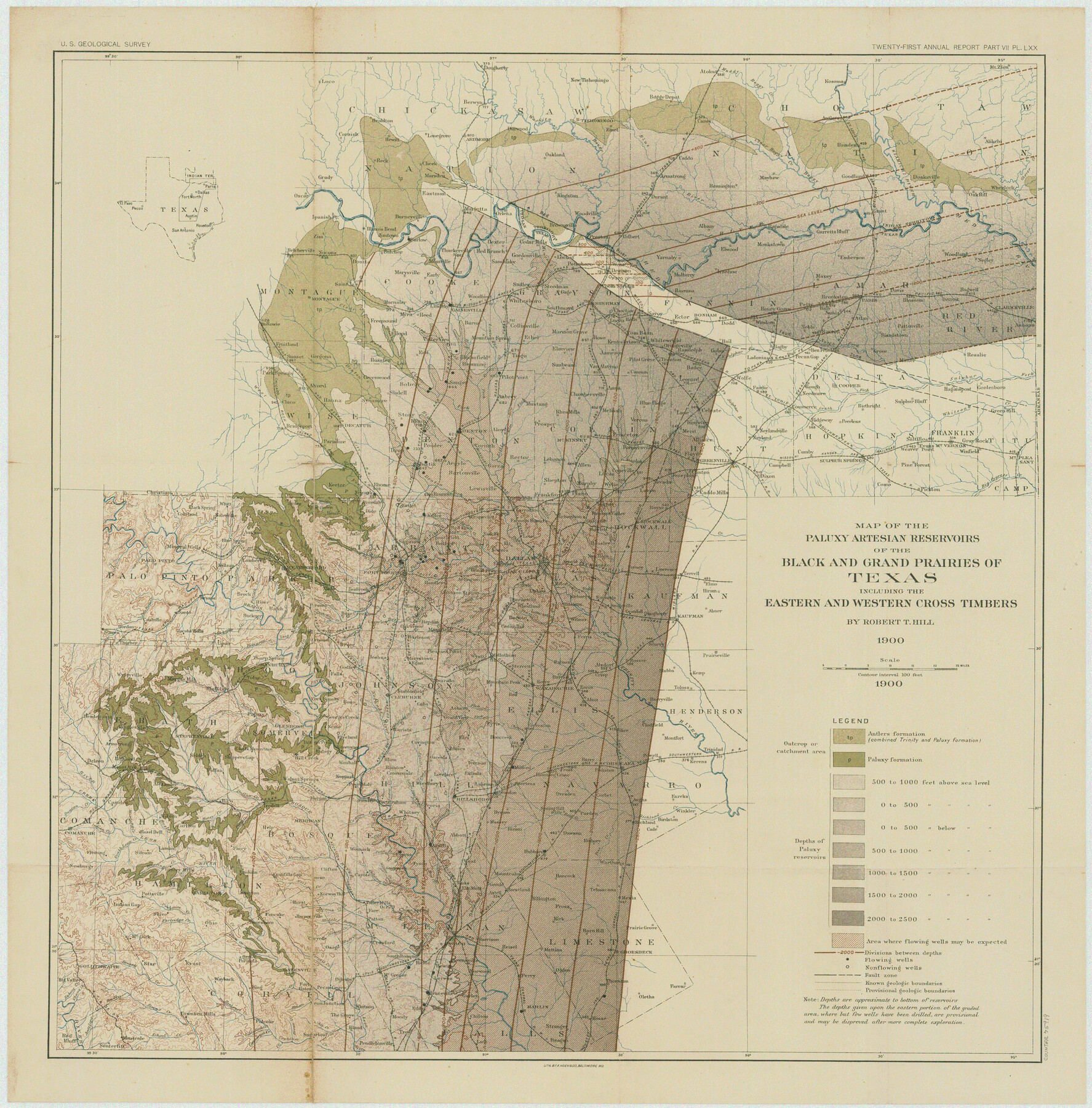
Map of the Paluxy Artesian Reservoirs of the Black and Grand Prairies of Texas including the Eastern and Western Cross Timbers
-
Map/Doc
75919
-
Collection
General Map Collection
-
Object Dates
1900 (Creation Date)
-
Subjects
Topographic
-
Height x Width
24.8 x 24.4 inches
63.0 x 62.0 cm
Part of: General Map Collection
Montague County Working Sketch 24

Print $20.00
- Digital $50.00
Montague County Working Sketch 24
1953
Size 21.9 x 27.6 inches
Map/Doc 71090
Red River County Rolled Sketch 4

Print $20.00
- Digital $50.00
Red River County Rolled Sketch 4
Size 37.3 x 32.2 inches
Map/Doc 9841

Gregg County Rolled Sketch 19

Print $82.00
- Digital $50.00
Gregg County Rolled Sketch 19
1932
Size 50.3 x 36.3 inches
Map/Doc 9069
Flight Mission No. DIX-10P, Frame 146, Aransas County

Print $20.00
- Digital $50.00
Flight Mission No. DIX-10P, Frame 146, Aransas County
1956
Size 18.6 x 22.4 inches
Map/Doc 83948
Stephens County Sketch File 24

Print $5.00
- Digital $50.00
Stephens County Sketch File 24
1952
Size 24.5 x 32.5 inches
Map/Doc 12354
Flight Mission No. CGI-1N, Frame 180, Cameron County

Print $20.00
- Digital $50.00
Flight Mission No. CGI-1N, Frame 180, Cameron County
1955
Size 18.5 x 22.2 inches
Map/Doc 84515
Hall County Sketch File 2

Print $12.00
- Digital $50.00
Hall County Sketch File 2
1880
Size 17.1 x 8.4 inches
Map/Doc 42261
Kerr County Working Sketch 11

Print $20.00
- Digital $50.00
Kerr County Working Sketch 11
1951
Size 30.3 x 29.9 inches
Map/Doc 70042

Cottle County Sketch File F

Print $6.00
- Digital $50.00
Cottle County Sketch File F
1935
Size 11.5 x 8.8 inches
Map/Doc 19444
Jasper County Sketch File 35

Print $6.00
- Digital $50.00
Jasper County Sketch File 35
Size 17.0 x 10.7 inches
Map/Doc 27870
You may also like
Maps of Gulf Intracoastal Waterway, Texas - Sabine River to the Rio Grande and connecting waterways including ship channels

Print $20.00
- Digital $50.00
Maps of Gulf Intracoastal Waterway, Texas - Sabine River to the Rio Grande and connecting waterways including ship channels
1966
Size 14.6 x 22.2 inches
Map/Doc 61971
Working Sketch in Lynn County

Print $20.00
- Digital $50.00
Working Sketch in Lynn County
1921
Size 15.1 x 18.9 inches
Map/Doc 91343
Travis County Working Sketch 26

Print $20.00
- Digital $50.00
Travis County Working Sketch 26
1951
Size 34.8 x 25.1 inches
Map/Doc 69410
Map of South America engraved to illustrate Mitchell's school and family geography

Print $20.00
- Digital $50.00
Map of South America engraved to illustrate Mitchell's school and family geography
1839
Size 11.8 x 9.5 inches
Map/Doc 93501
Brewster County Rolled Sketch 133

Print $20.00
- Digital $50.00
Brewster County Rolled Sketch 133
1979
Size 30.8 x 36.8 inches
Map/Doc 8524
Burnet County Sketch File 2

Print $4.00
- Digital $50.00
Burnet County Sketch File 2
Size 8.1 x 6.1 inches
Map/Doc 16672
[Val Verde County]
![63095, [Val Verde County], General Map Collection](https://historictexasmaps.com/wmedia_w700/maps/63095.tif.jpg)
Print $20.00
- Digital $50.00
[Val Verde County]
1898
Size 39.1 x 32.4 inches
Map/Doc 63095
Texas Official Travel Map

Digital $50.00
Texas Official Travel Map
Size 33.4 x 36.4 inches
Map/Doc 94424
San Patricio County Working Sketch 22

Print $20.00
- Digital $50.00
San Patricio County Working Sketch 22
1981
Size 30.0 x 24.1 inches
Map/Doc 63784
The Chief Justice County of Colorado. Lands in Conflict with Brazoria, Mina Counties

Print $20.00
The Chief Justice County of Colorado. Lands in Conflict with Brazoria, Mina Counties
2020
Size 14.8 x 21.7 inches
Map/Doc 96045
Young County Rolled Sketch 17

Print $20.00
- Digital $50.00
Young County Rolled Sketch 17
1984
Size 17.5 x 24.0 inches
Map/Doc 8305
