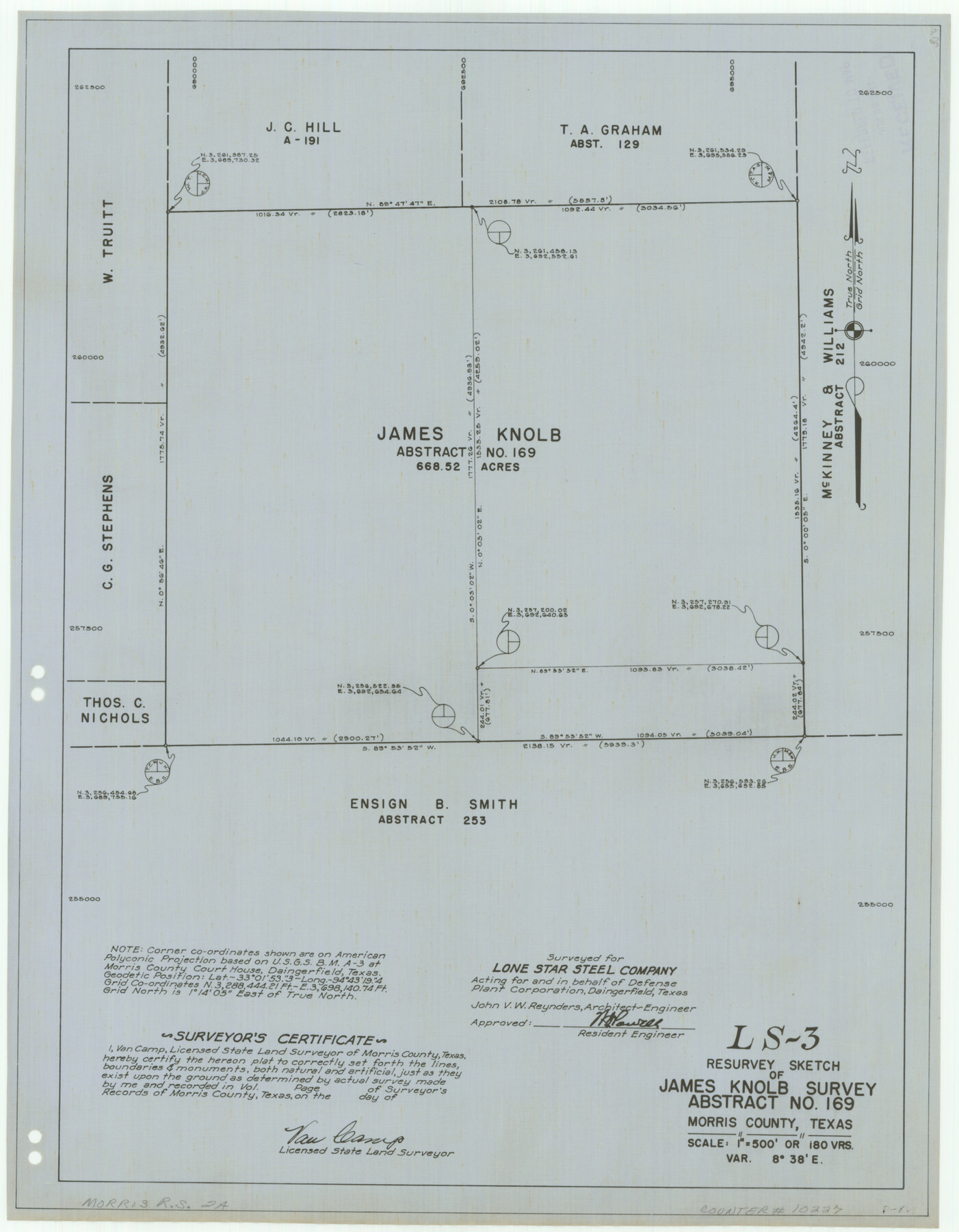
Morris County Rolled Sketch 2A
LS-3 - Resurvey sketch of James Knolb survey, abstract no. 169, Morris County, Texas
-
Map/Doc
10227
-
Collection
General Map Collection
-
People and Organizations
Van Camp (Surveyor/Engineer)
-
Counties
Morris
-
Subjects
Surveying Rolled Sketch
-
Height x Width
22.7 x 17.7 inches
57.7 x 45.0 cm
-
Medium
linen, manuscript
-
Scale
1" = 180 varas
-
Comments
See Morris County Rolled Sketch 2 (9550) for map of all retracement surveys made for Lone Star Steel Company.
Related maps
Morris County Rolled Sketch 2

Print $40.00
- Digital $50.00
Morris County Rolled Sketch 2
1944
Size 59.4 x 43.5 inches
Map/Doc 9550
Part of: General Map Collection

Montgomery County Rolled Sketch 38A

Print $40.00
- Digital $50.00
Montgomery County Rolled Sketch 38A
1962
Size 25.1 x 54.7 inches
Map/Doc 9546
Presidio County Working Sketch 74

Print $20.00
- Digital $50.00
Presidio County Working Sketch 74
1962
Size 45.9 x 35.2 inches
Map/Doc 71751
Dawson County Sketch File B

Print $10.00
- Digital $50.00
Dawson County Sketch File B
1917
Size 11.5 x 8.8 inches
Map/Doc 20465
Wichita County

Print $20.00
- Digital $50.00
Wichita County
1924
Size 32.1 x 39.1 inches
Map/Doc 16924
United States of North America (Eastern and Central)

Print $20.00
- Digital $50.00
United States of North America (Eastern and Central)
1862
Size 19.3 x 26.2 inches
Map/Doc 93667
[Affadavit regarding boundary lines between the several coastal counties from coastline to Continental Shelf]
![2089, [Affadavit regarding boundary lines between the several coastal counties from coastline to Continental Shelf], General Map Collection](https://historictexasmaps.com/wmedia_w700/maps/2089-1.tif.jpg)
Print $20.00
- Digital $50.00
[Affadavit regarding boundary lines between the several coastal counties from coastline to Continental Shelf]
1947
Size 18.1 x 12.7 inches
Map/Doc 2089
Photo Index of Texas Coast - Sheet 5 of 6

Print $20.00
- Digital $50.00
Photo Index of Texas Coast - Sheet 5 of 6
1954
Size 20.0 x 24.0 inches
Map/Doc 83443
Upshur County Working Sketch 15b

Print $20.00
- Digital $50.00
Upshur County Working Sketch 15b
1996
Size 36.7 x 29.4 inches
Map/Doc 69572
Trinity River, Owen Crossing Sheet/Elm Fork of Trinity River

Print $20.00
- Digital $50.00
Trinity River, Owen Crossing Sheet/Elm Fork of Trinity River
1914
Size 29.1 x 31.4 inches
Map/Doc 65201
Cass County Rolled Sketch 4

Print $20.00
- Digital $50.00
Cass County Rolled Sketch 4
1946
Size 20.2 x 15.1 inches
Map/Doc 5410
Van Zandt County Sketch File 42

Print $4.00
- Digital $50.00
Van Zandt County Sketch File 42
1874
Size 10.0 x 8.1 inches
Map/Doc 39495
You may also like
Flight Mission No. BRA-16M, Frame 126, Jefferson County

Print $20.00
- Digital $50.00
Flight Mission No. BRA-16M, Frame 126, Jefferson County
1953
Size 18.5 x 22.5 inches
Map/Doc 85736
El Paso County Sketch File 35 (5)

Print $6.00
- Digital $50.00
El Paso County Sketch File 35 (5)
1886
Size 14.6 x 8.9 inches
Map/Doc 22218
Flight Mission No. DQN-5K, Frame 23, Calhoun County

Print $20.00
- Digital $50.00
Flight Mission No. DQN-5K, Frame 23, Calhoun County
1953
Size 18.5 x 22.1 inches
Map/Doc 84374

Kimble County Working Sketch 59

Print $20.00
- Digital $50.00
Kimble County Working Sketch 59
1963
Size 24.6 x 40.8 inches
Map/Doc 70127
Comal County Working Sketch Graphic Index

Print $20.00
- Digital $50.00
Comal County Working Sketch Graphic Index
1947
Size 41.8 x 35.9 inches
Map/Doc 76501
Hamilton County Boundary File 5

Print $35.00
- Digital $50.00
Hamilton County Boundary File 5
Size 11.1 x 8.6 inches
Map/Doc 54217

Wood County Sketch File 10

Print $12.00
- Digital $50.00
Wood County Sketch File 10
1850
Size 8.3 x 12.8 inches
Map/Doc 40658
[Map showing connecting line from New Mexico to Double Lakes]
![91997, [Map showing connecting line from New Mexico to Double Lakes], Twichell Survey Records](https://historictexasmaps.com/wmedia_w700/maps/91997-1.tif.jpg)
Print $20.00
- Digital $50.00
[Map showing connecting line from New Mexico to Double Lakes]
1913
Size 39.3 x 24.2 inches
Map/Doc 91997

Smith County Boundary File 80

Print $8.00
- Digital $50.00
Smith County Boundary File 80
Size 9.0 x 6.2 inches
Map/Doc 58797