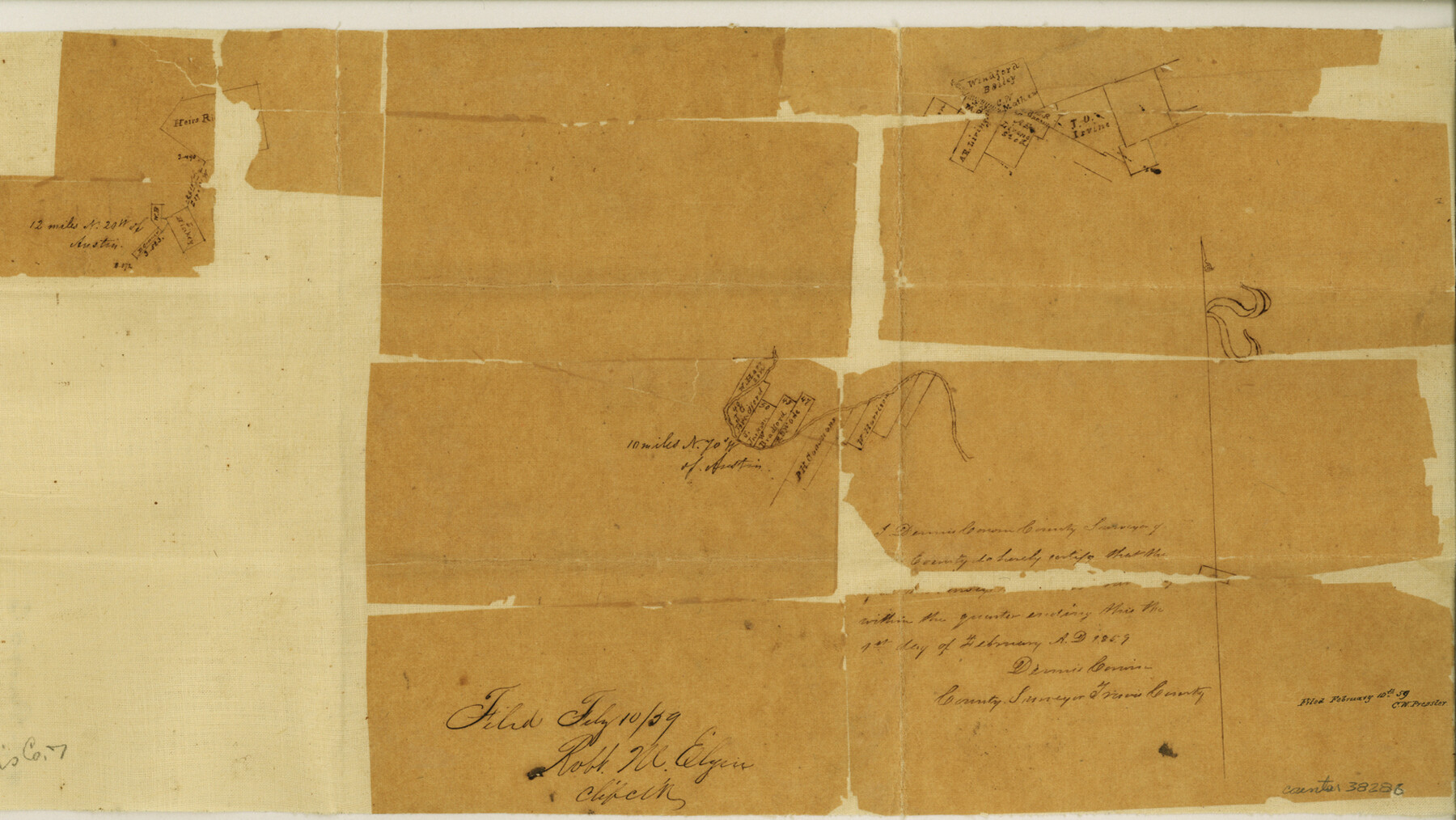
Travis County Sketch File 7
[Sketches of multiple areas in Travis County]
-
Map/Doc
38286
-
Collection
General Map Collection
-
Object Dates
2/1/1859 (Creation Date)
2/10/1859 (File Date)
-
People and Organizations
Dennis Corwin (Surveyor/Engineer)
-
Counties
Travis
-
Subjects
Surveying Sketch File
-
Height x Width
9.6 x 17.0 inches
24.4 x 43.2 cm
-
Medium
paper, manuscript
Part of: General Map Collection
Map of a part of Laguna Madre showing subdivision for mineral development

Print $40.00
- Digital $50.00
Map of a part of Laguna Madre showing subdivision for mineral development
1946
Size 50.0 x 29.0 inches
Map/Doc 2915
El Paso County Rolled Sketch 8

Print $40.00
- Digital $50.00
El Paso County Rolled Sketch 8
1882
Size 39.9 x 51.7 inches
Map/Doc 8852
Erath County Rolled Sketch 2

Print $20.00
- Digital $50.00
Erath County Rolled Sketch 2
Size 21.0 x 25.9 inches
Map/Doc 5861
Presidio County Rolled Sketch D1

Print $20.00
- Digital $50.00
Presidio County Rolled Sketch D1
Size 18.7 x 16.1 inches
Map/Doc 78524
Flight Mission No. DQO-12K, Frame 35, Galveston County

Print $20.00
- Digital $50.00
Flight Mission No. DQO-12K, Frame 35, Galveston County
1952
Size 18.7 x 22.4 inches
Map/Doc 85226
Pecos County Rolled Sketch 18

Print $20.00
- Digital $50.00
Pecos County Rolled Sketch 18
1882
Size 34.4 x 44.1 inches
Map/Doc 9683
Atascosa County Sketch File 1

Print $8.00
- Digital $50.00
Atascosa County Sketch File 1
Size 8.1 x 6.1 inches
Map/Doc 13718
Stephens County Sketch File 13

Print $4.00
- Digital $50.00
Stephens County Sketch File 13
Size 11.2 x 8.8 inches
Map/Doc 37063
Dickens County Sketch File D1

Print $50.00
- Digital $50.00
Dickens County Sketch File D1
Size 13.0 x 19.4 inches
Map/Doc 20833
Flight Mission No. BQR-7K, Frame 27, Brazoria County

Print $20.00
- Digital $50.00
Flight Mission No. BQR-7K, Frame 27, Brazoria County
1952
Size 18.6 x 22.3 inches
Map/Doc 84025
Flight Mission No. BRA-7M, Frame 27, Jefferson County

Print $20.00
- Digital $50.00
Flight Mission No. BRA-7M, Frame 27, Jefferson County
1953
Size 18.5 x 22.3 inches
Map/Doc 85478
Map of South Louisiana and Louisiana Continental Shelf showing Natural Gas Pipe Lines

Print $40.00
- Digital $50.00
Map of South Louisiana and Louisiana Continental Shelf showing Natural Gas Pipe Lines
Size 40.0 x 56.0 inches
Map/Doc 75906
You may also like
Glasscock County Working Sketch 11

Print $40.00
- Digital $50.00
Glasscock County Working Sketch 11
1957
Size 87.4 x 36.2 inches
Map/Doc 63184
Kinney County Working Sketch 47

Print $20.00
- Digital $50.00
Kinney County Working Sketch 47
1979
Size 40.5 x 39.1 inches
Map/Doc 70229
The Republic County of Matagorda. January 19, 1841

Print $20.00
The Republic County of Matagorda. January 19, 1841
2020
Size 21.0 x 21.7 inches
Map/Doc 96220
Duval County Sketch File 80

Print $32.00
- Digital $50.00
Duval County Sketch File 80
Size 14.1 x 8.9 inches
Map/Doc 21492
Denton County Sketch File 1

Print $2.00
- Digital $50.00
Denton County Sketch File 1
Size 8.4 x 10.6 inches
Map/Doc 20681
Map of Nacogdoches County

Print $20.00
- Digital $50.00
Map of Nacogdoches County
1881
Size 24.1 x 21.2 inches
Map/Doc 4603
Trinity County Boundary File 88a

Print $4.00
- Digital $50.00
Trinity County Boundary File 88a
Size 12.6 x 7.8 inches
Map/Doc 59478
[D. & P. Blk. G6 in SE Armstrong and SW Donley Counties]
![90269, [D. & P. Blk. G6 in SE Armstrong and SW Donley Counties], Twichell Survey Records](https://historictexasmaps.com/wmedia_w700/maps/90269-1.tif.jpg)
Print $3.00
- Digital $50.00
[D. & P. Blk. G6 in SE Armstrong and SW Donley Counties]
Size 11.7 x 9.4 inches
Map/Doc 90269
Jasper County Working Sketch 24
Print $40.00
- Digital $50.00
Jasper County Working Sketch 24
1948
Size 46.9 x 56.2 inches
Map/Doc 66486
[Sketch for Mineral Application 24072, San Jacinto River]
![65607, [Sketch for Mineral Application 24072, San Jacinto River], General Map Collection](https://historictexasmaps.com/wmedia_w700/maps/65607.tif.jpg)
Print $20.00
- Digital $50.00
[Sketch for Mineral Application 24072, San Jacinto River]
1929
Size 23.3 x 17.8 inches
Map/Doc 65607
Hudspeth County Rolled Sketch 42

Print $40.00
- Digital $50.00
Hudspeth County Rolled Sketch 42
1932
Size 12.7 x 156.8 inches
Map/Doc 9215
Hamilton County Working Sketch 8

Print $20.00
- Digital $50.00
Hamilton County Working Sketch 8
1943
Size 27.6 x 28.5 inches
Map/Doc 63346