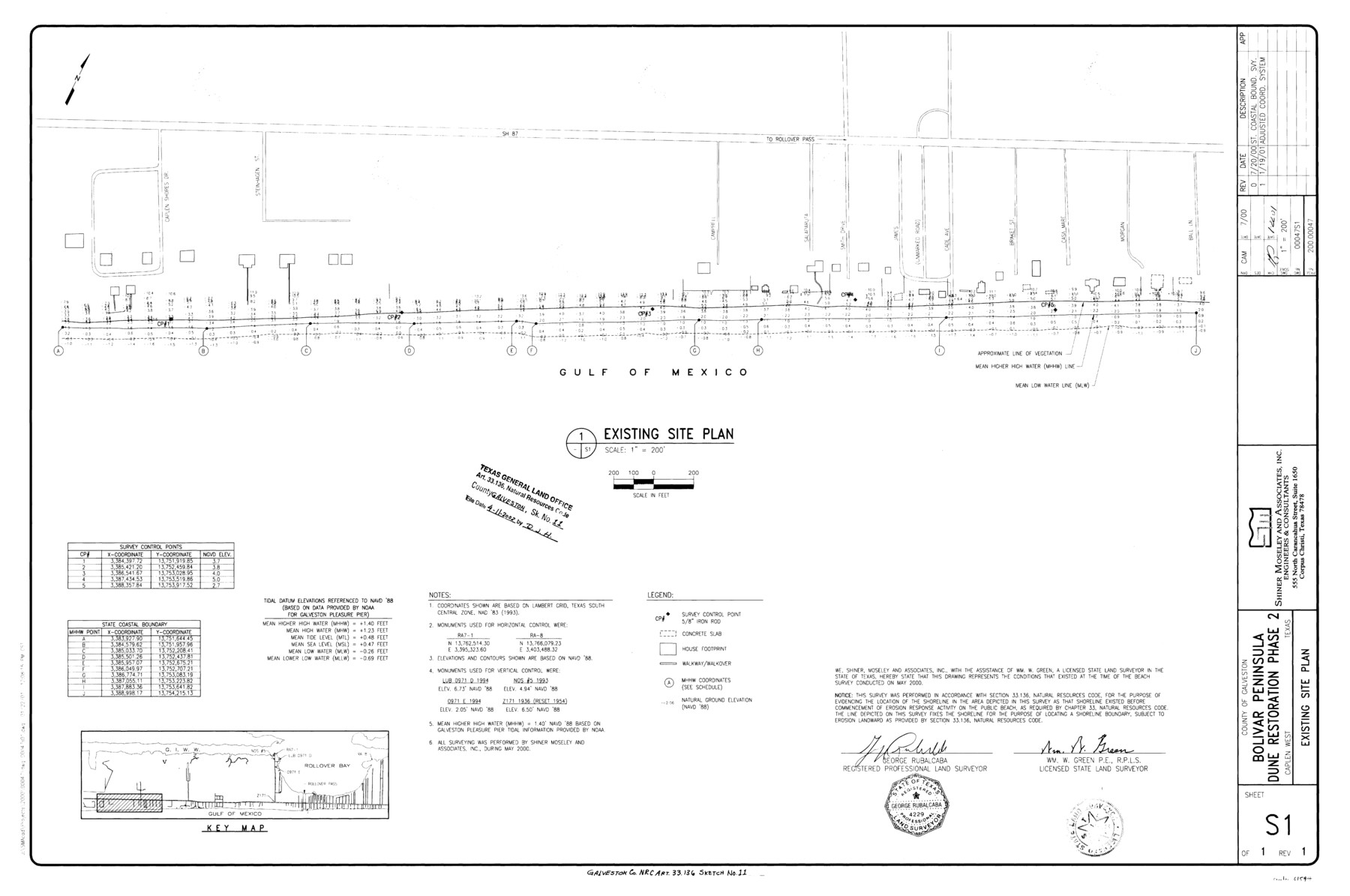
Galveston County NRC Article 33.136 Sketch 11
Bolivar Peninsula Dune Restoration Phase 2
-
Map/Doc
61594
-
Collection
General Map Collection
-
Object Dates
2001/1/22 (Creation Date)
2002/4/11 (File Date)
-
People and Organizations
Shiner Moseley & Associates, Inc. (Publisher)
Shiner Moseley & Associates, Inc. (Printer)
Wm. W. Green (Surveyor/Engineer)
CAM (Draftsman)
George Rubalcaba (Surveyor/Engineer)
-
Counties
Galveston
-
Subjects
Surveying CBS
-
Height x Width
22.5 x 33.9 inches
57.2 x 86.1 cm
-
Medium
mylar, print
-
Comments
Survey located about 20 miles North 50 degrees East of Galveston, Texas.
Part of: General Map Collection
[Maps of surveys in Reeves & Culberson Cos]
![61140, [Maps of surveys in Reeves & Culberson Cos], General Map Collection](https://historictexasmaps.com/wmedia_w700/maps/61140.tif.jpg)
Print $20.00
- Digital $50.00
[Maps of surveys in Reeves & Culberson Cos]
1937
Size 30.6 x 24.9 inches
Map/Doc 61140
Brooks County Working Sketch 19

Print $20.00
- Digital $50.00
Brooks County Working Sketch 19
1983
Size 31.7 x 18.4 inches
Map/Doc 67803
The Military History of Texas Map!

The Military History of Texas Map!
Size 24.2 x 35.2 inches
Map/Doc 94360
Rusk County Working Sketch 38

Print $20.00
- Digital $50.00
Rusk County Working Sketch 38
2008
Size 16.3 x 23.3 inches
Map/Doc 88815
[Sketch for Mineral Application 27670 - Strip between Simon Sanchez leagues and Trinity River]
![2865, [Sketch for Mineral Application 27670 - Strip between Simon Sanchez leagues and Trinity River], General Map Collection](https://historictexasmaps.com/wmedia_w700/maps/2865-1.tif.jpg)
Print $40.00
- Digital $50.00
[Sketch for Mineral Application 27670 - Strip between Simon Sanchez leagues and Trinity River]
1934
Size 17.3 x 50.5 inches
Map/Doc 2865
Montgomery County Sketch File 38

Print $8.00
- Digital $50.00
Montgomery County Sketch File 38
1899
Size 13.6 x 8.6 inches
Map/Doc 31919
Dickens County Sketch File F

Print $4.00
- Digital $50.00
Dickens County Sketch File F
1901
Size 6.9 x 10.7 inches
Map/Doc 20847

Kinney County Working Sketch 52

Print $6.00
- Digital $50.00
Kinney County Working Sketch 52
1980
Size 26.1 x 31.0 inches
Map/Doc 70234
Flight Mission No. CUG-3P, Frame 35, Kleberg County

Print $20.00
- Digital $50.00
Flight Mission No. CUG-3P, Frame 35, Kleberg County
1956
Size 18.6 x 22.3 inches
Map/Doc 86240

Burleson County Sketch File 10

Print $14.00
- Digital $50.00
Burleson County Sketch File 10
Size 11.5 x 8.3 inches
Map/Doc 16663
You may also like
Travis County Sketch File 23

Print $4.00
- Digital $50.00
Travis County Sketch File 23
1875
Size 12.8 x 8.5 inches
Map/Doc 38330
USGS Topographic: Texas-Oklahoma Denison Quadrangle

Print $20.00
- Digital $50.00
USGS Topographic: Texas-Oklahoma Denison Quadrangle
1901
Size 21.3 x 17.4 inches
Map/Doc 75108
Cherokee County Sketch File 31b

Print $6.00
- Digital $50.00
Cherokee County Sketch File 31b
1934
Size 14.2 x 8.9 inches
Map/Doc 18187
Kendall County Sketch File 8

Print $4.00
- Digital $50.00
Kendall County Sketch File 8
1879
Size 10.1 x 8.0 inches
Map/Doc 28690
Richardson's New Map of the State of Texas Corrected for the Texas Almanac

Print $20.00
Richardson's New Map of the State of Texas Corrected for the Texas Almanac
1870
Size 17.8 x 25.9 inches
Map/Doc 76192
Kent County Working Sketch 24

Print $20.00
- Digital $50.00
Kent County Working Sketch 24
1988
Size 30.5 x 21.2 inches
Map/Doc 70031
Flight Mission No. DAG-24K, Frame 146, Matagorda County

Print $20.00
- Digital $50.00
Flight Mission No. DAG-24K, Frame 146, Matagorda County
1953
Size 18.6 x 22.2 inches
Map/Doc 86560
Medina County Sketch File 15

Print $6.00
- Digital $50.00
Medina County Sketch File 15
1943
Size 14.2 x 8.5 inches
Map/Doc 31473
Connected Map of Austin's Colony

Print $40.00
- Digital $50.00
Connected Map of Austin's Colony
1837
Size 93.2 x 43.7 inches
Map/Doc 93377
La Salle County Working Sketch 7

Print $20.00
- Digital $50.00
La Salle County Working Sketch 7
1922
Size 35.0 x 36.5 inches
Map/Doc 70308
Ward County Rolled Sketch 14

Print $20.00
- Digital $50.00
Ward County Rolled Sketch 14
1940
Size 18.5 x 26.2 inches
Map/Doc 8157
Flight Mission No. CUG-2P, Frame 82, Kleberg County

Print $20.00
- Digital $50.00
Flight Mission No. CUG-2P, Frame 82, Kleberg County
1956
Size 18.5 x 22.3 inches
Map/Doc 86214