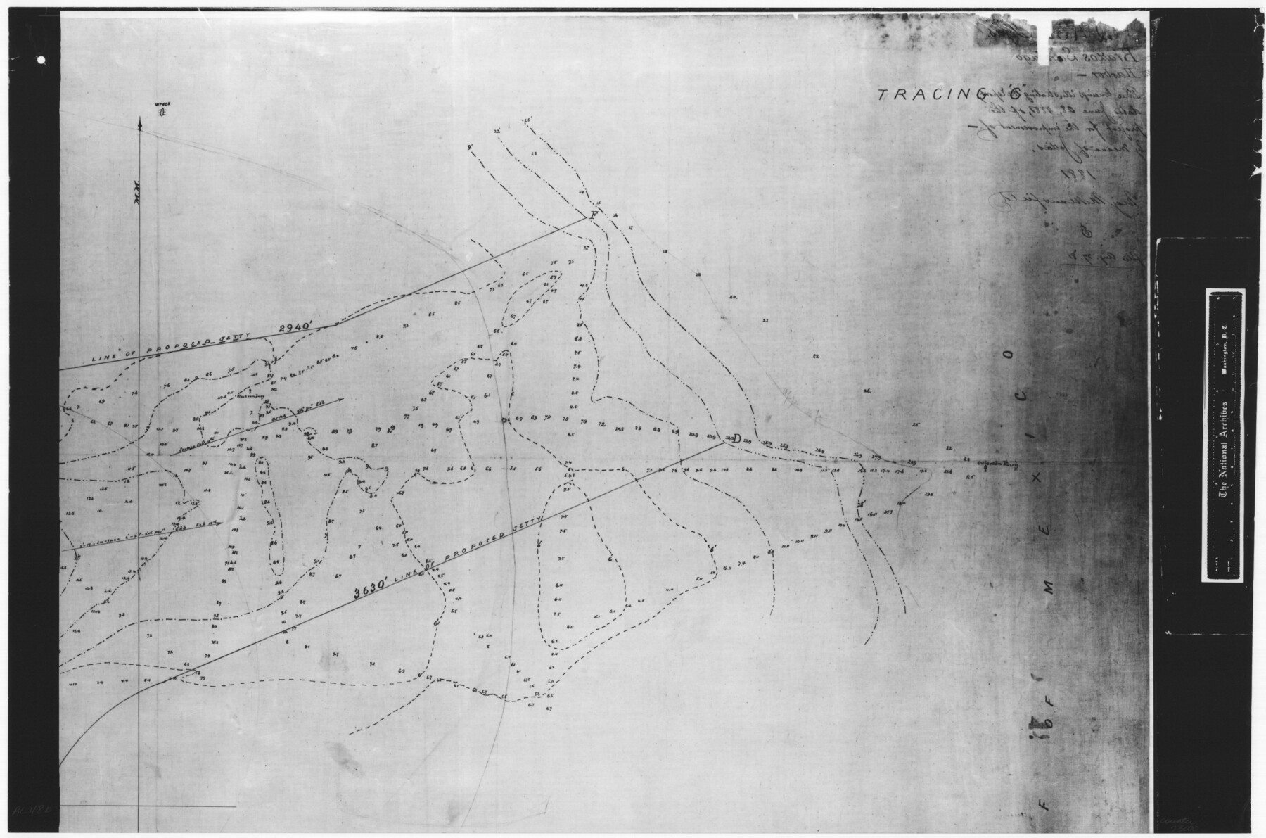
Harbor Pass and Bar at Brazos Santiago, Texas
RL-4-8b
-
Map/Doc
73000
-
Collection
General Map Collection
-
Object Dates
1879/2/10 (Creation Date)
-
People and Organizations
U. S. Army Engineers (Publisher)
U. S. Army Engineers (Author)
H.M. Adams (Surveyor/Engineer)
-
Subjects
Nautical Charts
-
Height x Width
18.2 x 27.5 inches
46.2 x 69.9 cm
-
Comments
B/W photostat copy from National Archives in multiple pieces.
Part of: General Map Collection
Old Miscellaneous File 21

Print $16.00
- Digital $50.00
Old Miscellaneous File 21
Size 14.3 x 8.7 inches
Map/Doc 75583
Jefferson County Rolled Sketch 60

Print $20.00
- Digital $50.00
Jefferson County Rolled Sketch 60
1885
Size 34.0 x 35.9 inches
Map/Doc 9316
[Abstract Numbering Register - Real through Zavala]
![82968, [Abstract Numbering Register - Real through Zavala], General Map Collection](https://historictexasmaps.com/wmedia_w700/pdf_converted_jpg/qi_pdf_thumbnail_30615.jpg)
[Abstract Numbering Register - Real through Zavala]
Map/Doc 82968
Jones County Working Sketch 2

Print $20.00
- Digital $50.00
Jones County Working Sketch 2
1928
Size 19.9 x 22.2 inches
Map/Doc 66640
Kerr County Working Sketch 19

Print $20.00
- Digital $50.00
Kerr County Working Sketch 19
1959
Size 34.5 x 41.3 inches
Map/Doc 70050
Dickens County Working Sketch 6

Print $20.00
- Digital $50.00
Dickens County Working Sketch 6
1932
Size 23.7 x 30.7 inches
Map/Doc 68654
McMullen County Rolled Sketch 12

Print $20.00
- Digital $50.00
McMullen County Rolled Sketch 12
Size 26.5 x 33.2 inches
Map/Doc 6729
Brazoria County Working Sketch 29

Print $20.00
- Digital $50.00
Brazoria County Working Sketch 29
1971
Size 30.6 x 28.3 inches
Map/Doc 67514
[Gulf, Colorado & Santa Fe Railway line through Fort Bend Co.]
![64212, [Gulf, Colorado & Santa Fe Railway line through Fort Bend Co.], General Map Collection](https://historictexasmaps.com/wmedia_w700/maps/64212.tif.jpg)
Print $20.00
- Digital $50.00
[Gulf, Colorado & Santa Fe Railway line through Fort Bend Co.]
1898
Size 14.2 x 33.5 inches
Map/Doc 64212
Ochiltree County

Print $20.00
- Digital $50.00
Ochiltree County
1958
Size 44.4 x 35.5 inches
Map/Doc 95603
Zapata County

Print $40.00
- Digital $50.00
Zapata County
1935
Size 55.9 x 42.2 inches
Map/Doc 73333
[G. C. & S. F. Ry. Alinement (sic) and Right of Way Map of Dallas Branch, Johnson County, Texas]
![64651, [G. C. & S. F. Ry. Alinement (sic) and Right of Way Map of Dallas Branch, Johnson County, Texas], General Map Collection](https://historictexasmaps.com/wmedia_w700/maps/64651.tif.jpg)
Print $40.00
- Digital $50.00
[G. C. & S. F. Ry. Alinement (sic) and Right of Way Map of Dallas Branch, Johnson County, Texas]
1926
Size 37.6 x 124.3 inches
Map/Doc 64651
You may also like
Hockley County Working Sketch Graphic Index

Print $20.00
- Digital $50.00
Hockley County Working Sketch Graphic Index
1954
Size 42.3 x 37.8 inches
Map/Doc 76579
Galveston County NRC Article 33.136 Sketch 24

Print $22.00
- Digital $50.00
Galveston County NRC Article 33.136 Sketch 24
2003
Size 24.8 x 36.3 inches
Map/Doc 87919
Reeves County Working Sketch 53

Print $40.00
- Digital $50.00
Reeves County Working Sketch 53
1977
Size 70.3 x 42.6 inches
Map/Doc 63496
Wilbarger County Sketch File 8

Print $4.00
- Digital $50.00
Wilbarger County Sketch File 8
1885
Size 14.2 x 8.6 inches
Map/Doc 40179
International boundary between U.S. & Mexico in Gulf of Mexico from 12 mile point easterly to 200 mile limit

Print $3.00
- Digital $50.00
International boundary between U.S. & Mexico in Gulf of Mexico from 12 mile point easterly to 200 mile limit
1976
Size 9.6 x 14.8 inches
Map/Doc 1748
Plano de la Sauteña. Indicando los terrenos irrigados en Texas

Plano de la Sauteña. Indicando los terrenos irrigados en Texas
Size 38.6 x 37.8 inches
Map/Doc 94566
Motley County Sketch File 9 (N)

Print $10.00
- Digital $50.00
Motley County Sketch File 9 (N)
1902
Size 11.1 x 8.6 inches
Map/Doc 32019
Map of the Interior of Louisiana with a part of New Mexico

Print $20.00
- Digital $50.00
Map of the Interior of Louisiana with a part of New Mexico
1813
Size 11.9 x 15.7 inches
Map/Doc 94460
North Part of Brewster Co.

Print $20.00
- Digital $50.00
North Part of Brewster Co.
1956
Size 42.1 x 40.2 inches
Map/Doc 73088
Lynn County Boundary File 11

Print $44.00
- Digital $50.00
Lynn County Boundary File 11
Size 14.1 x 8.7 inches
Map/Doc 56745
Johnson County Working Sketch 11

Print $20.00
- Digital $50.00
Johnson County Working Sketch 11
1953
Size 28.7 x 22.4 inches
Map/Doc 66624
Hood County Sketch File 7

Print $6.00
- Digital $50.00
Hood County Sketch File 7
Size 12.9 x 7.9 inches
Map/Doc 26581