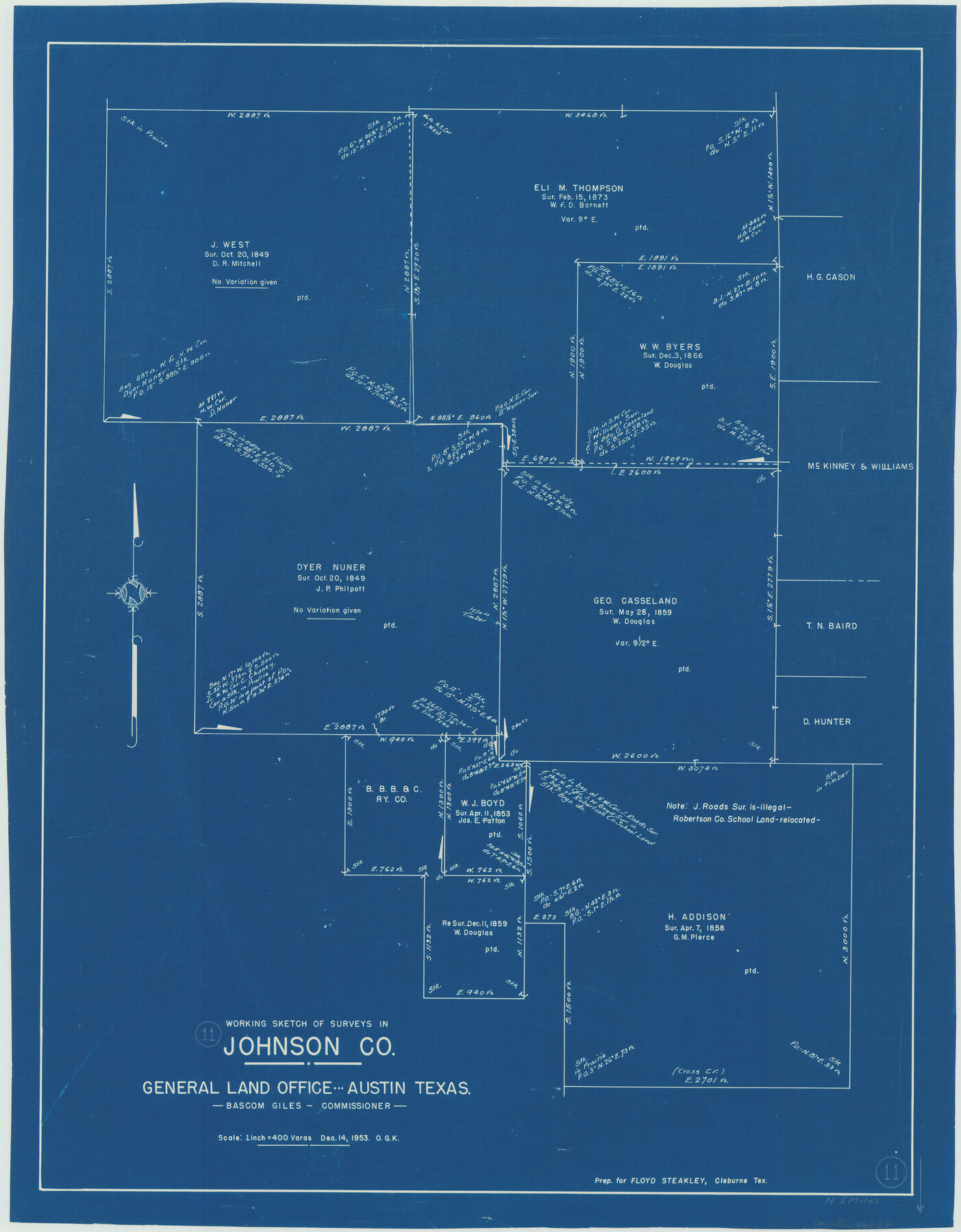
Johnson County Working Sketch 11
-
Map/Doc
66624
-
Collection
General Map Collection
-
Object Dates
12/14/1953 (Creation Date)
-
People and Organizations
Otto G. Kurio (Draftsman)
-
Counties
Johnson
-
Subjects
Surveying Working Sketch
-
Height x Width
28.7 x 22.4 inches
72.9 x 56.9 cm
-
Scale
1" = 400 varas
Part of: General Map Collection
Presidio County Sketch File 19

Print $16.00
- Digital $50.00
Presidio County Sketch File 19
1885
Size 14.2 x 8.9 inches
Map/Doc 34444
Uvalde County Working Sketch 51

Print $20.00
- Digital $50.00
Uvalde County Working Sketch 51
1981
Size 34.7 x 37.7 inches
Map/Doc 72121
Flight Mission No. DQN-2K, Frame 24, Calhoun County

Print $20.00
- Digital $50.00
Flight Mission No. DQN-2K, Frame 24, Calhoun County
1953
Size 18.6 x 22.2 inches
Map/Doc 84231
Liberty County Working Sketch 40

Print $20.00
- Digital $50.00
Liberty County Working Sketch 40
1952
Size 24.1 x 32.9 inches
Map/Doc 70499
Armstrong County Sketch File 6

Print $26.00
- Digital $50.00
Armstrong County Sketch File 6
Size 12.8 x 8.2 inches
Map/Doc 13689
Coleman County Working Sketch 11

Print $20.00
- Digital $50.00
Coleman County Working Sketch 11
1950
Size 24.2 x 18.2 inches
Map/Doc 68077
El Paso County Rolled Sketch 51

Print $40.00
- Digital $50.00
El Paso County Rolled Sketch 51
Size 42.9 x 75.3 inches
Map/Doc 8877
Concho County Sketch File 3

Print $6.00
- Digital $50.00
Concho County Sketch File 3
1857
Size 13.1 x 8.4 inches
Map/Doc 19124
Pecos County Rolled Sketch 107

Print $20.00
- Digital $50.00
Pecos County Rolled Sketch 107
1940
Size 21.9 x 45.4 inches
Map/Doc 7253
Terrell County Working Sketch 35a

Print $20.00
- Digital $50.00
Terrell County Working Sketch 35a
1948
Size 26.4 x 45.1 inches
Map/Doc 62128
Brazoria County NRC Article 33.136 Sketch 20

Print $36.00
- Digital $50.00
Brazoria County NRC Article 33.136 Sketch 20
2020
Map/Doc 96878
Flight Mission No. DAG-21K, Frame 97, Matagorda County

Print $20.00
- Digital $50.00
Flight Mission No. DAG-21K, Frame 97, Matagorda County
1952
Size 18.4 x 22.2 inches
Map/Doc 86426
You may also like
Bandera County Working Sketch 35

Print $20.00
- Digital $50.00
Bandera County Working Sketch 35
1965
Size 20.8 x 21.6 inches
Map/Doc 67631
Schleicher County Sketch File 15

Print $22.00
- Digital $50.00
Schleicher County Sketch File 15
1928
Size 8.1 x 12.9 inches
Map/Doc 36504
Rio Grande Rectification Project, El Paso and Juarez Valley

Print $20.00
- Digital $50.00
Rio Grande Rectification Project, El Paso and Juarez Valley
1935
Size 10.7 x 29.6 inches
Map/Doc 60862
Map of Drum, Oyster & Bastrop Bays & vicinity in Brazoria County showing subdivision for mineral development

Print $20.00
- Digital $50.00
Map of Drum, Oyster & Bastrop Bays & vicinity in Brazoria County showing subdivision for mineral development
Size 36.8 x 47.3 inches
Map/Doc 65808
[Copy of a portion of] The Coast & Bays of Western Texas, St. Joseph's and Mustang Islands from Actual Survey, the Remainder from County Maps, Etc.
![72768, [Copy of a portion of] The Coast & Bays of Western Texas, St. Joseph's and Mustang Islands from Actual Survey, the Remainder from County Maps, Etc., General Map Collection](https://historictexasmaps.com/wmedia_w700/maps/72768.tif.jpg)
Print $20.00
- Digital $50.00
[Copy of a portion of] The Coast & Bays of Western Texas, St. Joseph's and Mustang Islands from Actual Survey, the Remainder from County Maps, Etc.
1857
Size 26.0 x 18.3 inches
Map/Doc 72768
[Stephen F. Austin's Map of Texas]
![95825, [Stephen F. Austin's Map of Texas], Non-GLO Digital Images](https://historictexasmaps.com/wmedia_w700/maps/95825.tif.jpg)
[Stephen F. Austin's Map of Texas]
1829
Size 21.7 x 17.9 inches
Map/Doc 95825
Galveston County NRC Article 33.136 Sketch 23

Print $22.00
- Digital $50.00
Galveston County NRC Article 33.136 Sketch 23
2002
Size 11.4 x 16.4 inches
Map/Doc 81905
Flight Mission No. DQN-5K, Frame 59, Calhoun County

Print $20.00
- Digital $50.00
Flight Mission No. DQN-5K, Frame 59, Calhoun County
1953
Size 18.7 x 22.3 inches
Map/Doc 84402
Flight Mission No. CRC-3R, Frame 195, Chambers County

Print $20.00
- Digital $50.00
Flight Mission No. CRC-3R, Frame 195, Chambers County
1956
Size 18.5 x 22.2 inches
Map/Doc 84850
[Sketch showing PSL Blocks A39, A40, A50-A57]
![89737, [Sketch showing PSL Blocks A39, A40, A50-A57], Twichell Survey Records](https://historictexasmaps.com/wmedia_w700/maps/89737-1.tif.jpg)
Print $40.00
- Digital $50.00
[Sketch showing PSL Blocks A39, A40, A50-A57]
Size 27.8 x 63.5 inches
Map/Doc 89737
Houston County Sketch File 26

Print $4.00
- Digital $50.00
Houston County Sketch File 26
1873
Size 8.0 x 6.8 inches
Map/Doc 26800
Houston Ship Channel, Atkinson Island to Alexander Island

Print $40.00
- Digital $50.00
Houston Ship Channel, Atkinson Island to Alexander Island
1992
Size 37.1 x 54.3 inches
Map/Doc 69904