Wilbarger County Sketch File 8
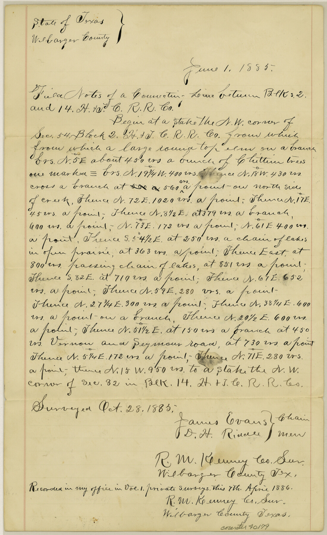
[Field notes of a connecting line between Blocks 2 and 14, H. & T. C. R.R. Co.]
-
Map/Doc
40179
-
Collection
General Map Collection
-
Object Dates
6/1/1885 (Creation Date)
4/10/1886 (File Date)
-
People and Organizations
James Evans (Chainman/Field Personnel)
D.H. Riddle (Chainman/Field Personnel)
R.M. Kenney (Surveyor/Engineer)
-
Counties
Wilbarger
-
Subjects
Surveying Sketch File
-
Height x Width
14.2 x 8.6 inches
36.1 x 21.8 cm
-
Medium
paper, bound volume
Part of: General Map Collection
Galveston Bay Texas Lower Part Encluding [sic] Bar and Entrance
![69869, Galveston Bay Texas Lower Part Encluding [sic] Bar and Entrance, General Map Collection](https://historictexasmaps.com/wmedia_w700/maps/69869-1.tif.jpg)
Print $40.00
- Digital $50.00
Galveston Bay Texas Lower Part Encluding [sic] Bar and Entrance
1867
Size 52.6 x 39.1 inches
Map/Doc 69869
Kent County Working Sketch 8

Print $20.00
- Digital $50.00
Kent County Working Sketch 8
1952
Size 27.2 x 37.1 inches
Map/Doc 70015
Sabine Pass and Lake

Print $20.00
- Digital $50.00
Sabine Pass and Lake
1975
Size 46.9 x 27.8 inches
Map/Doc 69827
Map of the River Sabine from its mouth on the Gulf of Mexico in the Sea to Logan's Ferry in Latitude 31°58'24" North

Print $40.00
- Digital $50.00
Map of the River Sabine from its mouth on the Gulf of Mexico in the Sea to Logan's Ferry in Latitude 31°58'24" North
1842
Size 173.2 x 31.0 inches
Map/Doc 1744
Val Verde County Sketch File 51b

Print $6.00
- Digital $50.00
Val Verde County Sketch File 51b
Size 10.1 x 8.8 inches
Map/Doc 39329
Flight Mission No. DCL-7C, Frame 6, Kenedy County

Print $20.00
- Digital $50.00
Flight Mission No. DCL-7C, Frame 6, Kenedy County
1943
Size 15.5 x 15.4 inches
Map/Doc 85998
Atascosa County Sketch File 23

Print $40.00
- Digital $50.00
Atascosa County Sketch File 23
Size 17.1 x 21.2 inches
Map/Doc 10860
Flight Mission No. CRC-3R, Frame 196, Chambers County

Print $20.00
- Digital $50.00
Flight Mission No. CRC-3R, Frame 196, Chambers County
1956
Size 18.7 x 22.3 inches
Map/Doc 84851
A map of Lewis and Clark's track across the western portion of North America from the Mississippi to the Pacific Ocean, by Order of the executive of the United States in 1804, 5, & 6

Print $20.00
- Digital $50.00
A map of Lewis and Clark's track across the western portion of North America from the Mississippi to the Pacific Ocean, by Order of the executive of the United States in 1804, 5, & 6
1814
Size 13.3 x 27.9 inches
Map/Doc 97412
Flight Mission No. BQR-7K, Frame 23, Brazoria County

Print $20.00
- Digital $50.00
Flight Mission No. BQR-7K, Frame 23, Brazoria County
1952
Size 18.4 x 22.2 inches
Map/Doc 84021

Castro County Sketch File 12

Print $10.00
- Digital $50.00
Castro County Sketch File 12
1910
Size 11.1 x 8.6 inches
Map/Doc 17505
You may also like
Edwards County Sketch File 6

Print $20.00
- Digital $50.00
Edwards County Sketch File 6
1880
Size 11.7 x 19.6 inches
Map/Doc 11419
Fisher County Working Sketch 3

Print $20.00
- Digital $50.00
Fisher County Working Sketch 3
1926
Size 19.7 x 15.7 inches
Map/Doc 69137
[H. & G. N. Block 1]
![90941, [H. & G. N. Block 1], Twichell Survey Records](https://historictexasmaps.com/wmedia_w700/maps/90941-1.tif.jpg)
Print $20.00
- Digital $50.00
[H. & G. N. Block 1]
1873
Size 17.5 x 14.3 inches
Map/Doc 90941
Zapata County Sketch File 12

Print $20.00
- Digital $50.00
Zapata County Sketch File 12
1918
Size 15.6 x 33.0 inches
Map/Doc 12721
University Lands, Blocks 34 to 37, Terrell County

Print $20.00
- Digital $50.00
University Lands, Blocks 34 to 37, Terrell County
1938
Size 32.5 x 40.0 inches
Map/Doc 2417
Map of Surveys in Oldham County

Print $20.00
- Digital $50.00
Map of Surveys in Oldham County
1903
Size 12.5 x 17.0 inches
Map/Doc 91449
Brooks County Boundary File 1c

Print $40.00
- Digital $50.00
Brooks County Boundary File 1c
Size 63.4 x 6.7 inches
Map/Doc 50838
Railroad Track Map, H&TCRRCo., Falls County, Texas

Print $4.00
- Digital $50.00
Railroad Track Map, H&TCRRCo., Falls County, Texas
1918
Size 11.4 x 18.5 inches
Map/Doc 62859
San Jacinto County Sketch File 24

Print $18.00
San Jacinto County Sketch File 24
2001
Size 14.5 x 8.9 inches
Map/Doc 35816
[Parts of PSL Blocks B18, B19, B28, B20 and B29]
![91952, [Parts of PSL Blocks B18, B19, B28, B20 and B29], Twichell Survey Records](https://historictexasmaps.com/wmedia_w700/maps/91952-1.tif.jpg)
Print $20.00
- Digital $50.00
[Parts of PSL Blocks B18, B19, B28, B20 and B29]
Size 21.4 x 28.0 inches
Map/Doc 91952
Uvalde County Working Sketch 67

Print $20.00
- Digital $50.00
Uvalde County Working Sketch 67
2016
Size 24.4 x 36.6 inches
Map/Doc 94082
McCulloch County Sketch File 12

Print $6.00
- Digital $50.00
McCulloch County Sketch File 12
1989
Size 14.2 x 8.6 inches
Map/Doc 31198