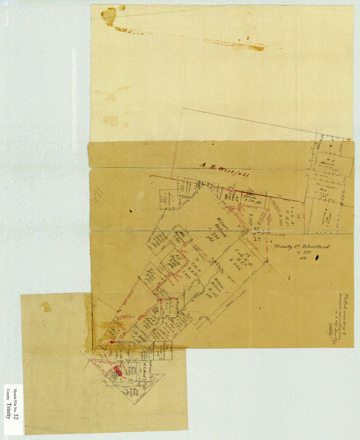
Trinity County Sketch File 32
[Office sketch of area north of Groveton plotted according to surveyor's connecting lines in HOU S-497]
-
Map/Doc
12490
-
Collection
General Map Collection
-
Object Dates
5/15/1894 (Creation Date)
-
People and Organizations
E. Schutze (Draftsman)
-
Counties
Trinity
-
Subjects
Surveying Sketch File
-
Height x Width
22.4 x 18.3 inches
56.9 x 46.5 cm
-
Medium
paper, manuscript
-
Features
Long Prairie Creek
Part of: General Map Collection
Navarro County Working Sketch 15

Print $20.00
- Digital $50.00
Navarro County Working Sketch 15
1993
Size 16.1 x 17.8 inches
Map/Doc 71245
Pecos County Sketch File 81

Print $14.00
- Digital $50.00
Pecos County Sketch File 81
1941
Size 11.3 x 8.7 inches
Map/Doc 33920
Flight Mission No. CRE-2R, Frame 155, Jackson County

Print $20.00
- Digital $50.00
Flight Mission No. CRE-2R, Frame 155, Jackson County
1956
Size 16.1 x 16.1 inches
Map/Doc 85366
Flight Mission No. CGI-3N, Frame 142, Cameron County

Print $20.00
- Digital $50.00
Flight Mission No. CGI-3N, Frame 142, Cameron County
1954
Size 18.7 x 22.3 inches
Map/Doc 84615
Voyages Autour du Monde, et vers les deux poles par terre et par mer - Tome Premier

Voyages Autour du Monde, et vers les deux poles par terre et par mer - Tome Premier
1782
Map/Doc 97085
Liberty County Sketch File 30

Print $6.00
- Digital $50.00
Liberty County Sketch File 30
Size 10.5 x 11.3 inches
Map/Doc 29957
Starr County Sketch File 32B

Print $20.00
- Digital $50.00
Starr County Sketch File 32B
1938
Size 19.9 x 21.5 inches
Map/Doc 12336
Cherokee County Working Sketch 1

Print $20.00
- Digital $50.00
Cherokee County Working Sketch 1
1925
Size 22.9 x 24.1 inches
Map/Doc 67956
[Del Rio, Texas]
![2070, [Del Rio, Texas], General Map Collection](https://historictexasmaps.com/wmedia_w700/maps/2070-1.tif.jpg)
Print $20.00
- Digital $50.00
[Del Rio, Texas]
1886
Size 24.2 x 34.3 inches
Map/Doc 2070
Pecos County Rolled Sketch 22

Print $20.00
- Digital $50.00
Pecos County Rolled Sketch 22
1886
Size 22.4 x 36.8 inches
Map/Doc 93454
Galveston County Sketch File 18

Print $4.00
- Digital $50.00
Galveston County Sketch File 18
Size 5.5 x 8.0 inches
Map/Doc 23388
Bastrop County Working Sketch 2

Print $20.00
- Digital $50.00
Bastrop County Working Sketch 2
1913
Size 14.0 x 13.6 inches
Map/Doc 67302
You may also like
El Paso County Boundary File 13

Print $37.00
- Digital $50.00
El Paso County Boundary File 13
Size 11.1 x 8.6 inches
Map/Doc 53161
Polk County Rolled Sketch 29

Print $86.00
- Digital $50.00
Polk County Rolled Sketch 29
1954
Size 9.3 x 14.9 inches
Map/Doc 48066
Cass County Rolled Sketch 2

Print $20.00
- Digital $50.00
Cass County Rolled Sketch 2
1936
Size 35.2 x 18.0 inches
Map/Doc 5409
Jasper County

Print $40.00
- Digital $50.00
Jasper County
1946
Size 49.8 x 43.9 inches
Map/Doc 95542
[Surveys along San Antonio Road]
![90110, [Surveys along San Antonio Road], Twichell Survey Records](https://historictexasmaps.com/wmedia_w700/maps/90110-1.tif.jpg)
Print $20.00
- Digital $50.00
[Surveys along San Antonio Road]
Size 23.0 x 13.7 inches
Map/Doc 90110
Val Verde County Working Sketch 24

Print $20.00
- Digital $50.00
Val Verde County Working Sketch 24
1936
Size 21.5 x 21.6 inches
Map/Doc 72159
McMullen County Sketch File 40

Print $6.00
- Digital $50.00
McMullen County Sketch File 40
1939
Size 14.2 x 8.7 inches
Map/Doc 31415
Bexar County Working Sketch 12

Print $20.00
- Digital $50.00
Bexar County Working Sketch 12
1954
Size 24.7 x 21.0 inches
Map/Doc 67328
Ellis County, Texas

Print $20.00
- Digital $50.00
Ellis County, Texas
1879
Size 21.2 x 29.6 inches
Map/Doc 714
Wichita County Sketch File 22

Print $10.00
- Digital $50.00
Wichita County Sketch File 22
1911
Size 11.3 x 8.6 inches
Map/Doc 40104
Presidio County Sketch File 112

Print $166.00
- Digital $50.00
Presidio County Sketch File 112
1983
Size 12.1 x 31.2 inches
Map/Doc 11727
Crockett County Working Sketch 64

Print $20.00
- Digital $50.00
Crockett County Working Sketch 64
1957
Size 19.0 x 25.4 inches
Map/Doc 68397