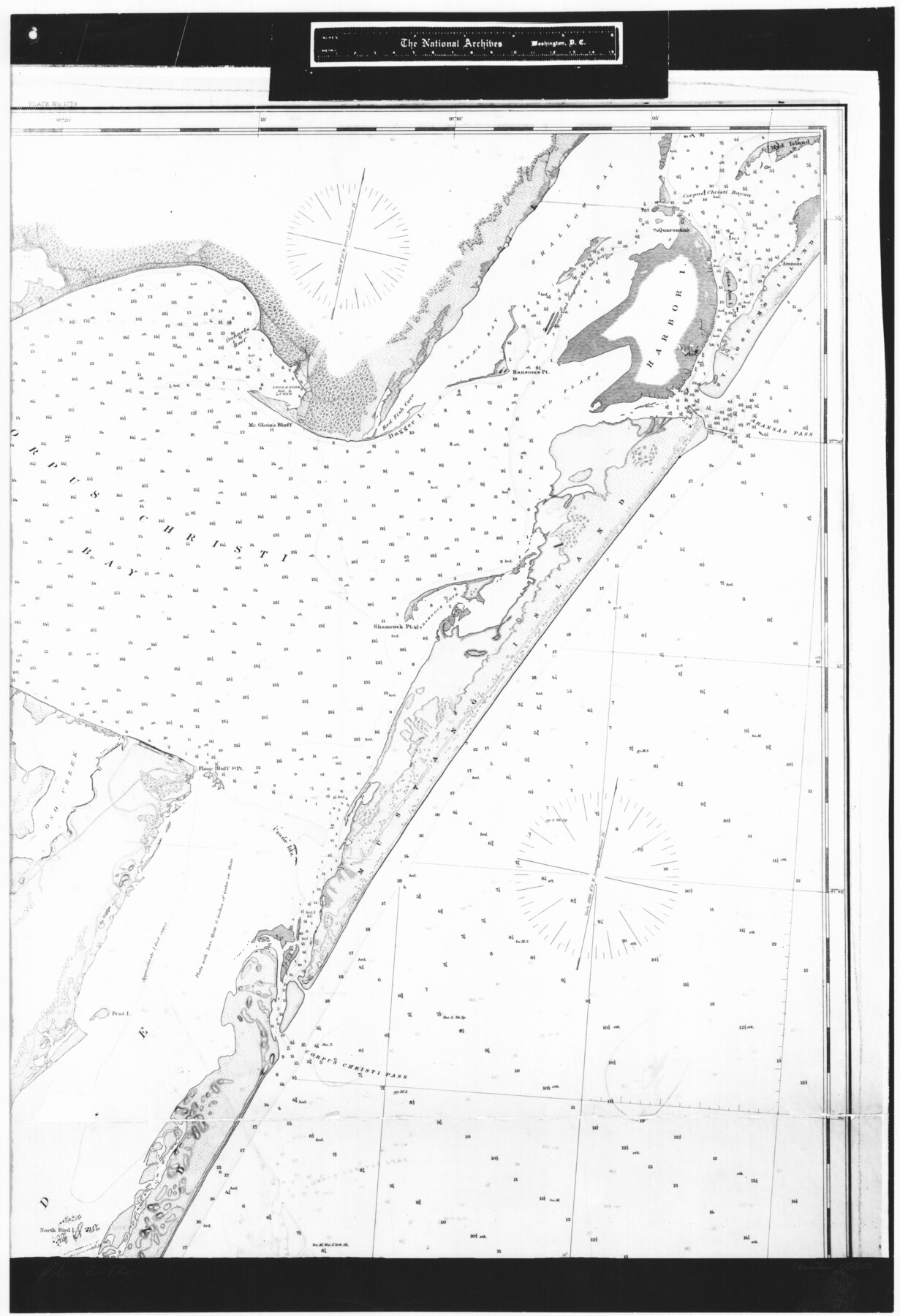
Coast Chart No. 210 Aransas Pass and Corpus Christi Bay with the coast to latitude 27° 12' Texas
RL-2-12
-
Map/Doc
72810
-
Collection
General Map Collection
-
Object Dates
1887 (Creation Date)
-
People and Organizations
[U. S. Coast and Geodetic Survey] (Publisher)
-
Counties
Nueces
-
Subjects
Nautical Charts
-
Height x Width
26.7 x 18.3 inches
67.8 x 46.5 cm
-
Comments
B/W photostat copy from National Archives in multiple pieces.
Part of: General Map Collection
Duval County Boundary File 3d

Print $8.00
- Digital $50.00
Duval County Boundary File 3d
Size 14.2 x 8.8 inches
Map/Doc 52738
Anderson County

Print $40.00
- Digital $50.00
Anderson County
1942
Size 52.9 x 47.9 inches
Map/Doc 66702
Flight Mission No. DQN-3K, Frame 63, Calhoun County

Print $20.00
- Digital $50.00
Flight Mission No. DQN-3K, Frame 63, Calhoun County
1953
Size 18.4 x 22.3 inches
Map/Doc 84354
Marion County Working Sketch 41

Print $40.00
- Digital $50.00
Marion County Working Sketch 41
1996
Size 34.0 x 48.5 inches
Map/Doc 70817
[Cotton Belt, St. Louis Southwestern Railway of Texas, Alignment through Smith County]
![64385, [Cotton Belt, St. Louis Southwestern Railway of Texas, Alignment through Smith County], General Map Collection](https://historictexasmaps.com/wmedia_w700/maps/64385.tif.jpg)
Print $20.00
- Digital $50.00
[Cotton Belt, St. Louis Southwestern Railway of Texas, Alignment through Smith County]
1903
Size 21.6 x 29.8 inches
Map/Doc 64385
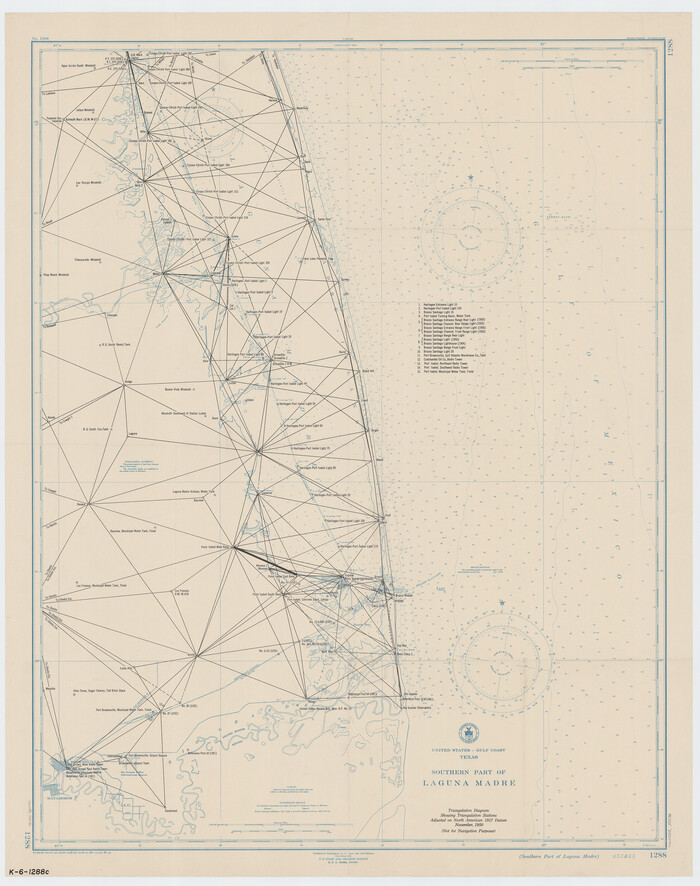
Southern Part of Laguna Madre
Print $20.00
- Digital $50.00
Southern Part of Laguna Madre
1949
Size 33.8 x 26.7 inches
Map/Doc 73536
Donley County Working Sketch 1

Print $20.00
- Digital $50.00
Donley County Working Sketch 1
1914
Size 19.0 x 19.7 inches
Map/Doc 68734
Hamilton County Rolled Sketch 13

Print $20.00
- Digital $50.00
Hamilton County Rolled Sketch 13
1982
Size 34.0 x 28.0 inches
Map/Doc 6062
Mitchell County Boundary File 1a

Print $32.00
- Digital $50.00
Mitchell County Boundary File 1a
Size 13.4 x 8.6 inches
Map/Doc 57344
![94161, Austin and Vicinity [Verso], General Map Collection](https://historictexasmaps.com/wmedia_w700/maps/94161.tif.jpg)
Hutchinson County Sketch File 44a

Print $4.00
- Digital $50.00
Hutchinson County Sketch File 44a
1989
Size 11.2 x 8.7 inches
Map/Doc 27352
Lake Austin, Travis County, Texas

Print $20.00
- Digital $50.00
Lake Austin, Travis County, Texas
1937
Size 24.8 x 16.4 inches
Map/Doc 2056
You may also like
Sutton County Working Sketch 2

Print $20.00
- Digital $50.00
Sutton County Working Sketch 2
1968
Size 31.2 x 29.3 inches
Map/Doc 62345
Gaines County Working Sketch Graphic Index

Print $40.00
- Digital $50.00
Gaines County Working Sketch Graphic Index
1956
Size 42.7 x 54.0 inches
Map/Doc 76550
Rusk County Sketch File 12

Print $6.00
- Digital $50.00
Rusk County Sketch File 12
1845
Size 8.4 x 7.9 inches
Map/Doc 35511
Calhoun County NRC Article 33.136 Sketch 7

Print $63.00
- Digital $50.00
Calhoun County NRC Article 33.136 Sketch 7
2016
Size 17.1 x 21.8 inches
Map/Doc 94867
Cuadro Historico-Geroglifico de la Peregrinacion de las Tribus Aztecas que Poblaron el Valle de Mexico (Num. 2)

Print $20.00
- Digital $50.00
Cuadro Historico-Geroglifico de la Peregrinacion de las Tribus Aztecas que Poblaron el Valle de Mexico (Num. 2)
Size 22.9 x 31.3 inches
Map/Doc 97012
Map of Lipscomb County

Print $20.00
- Digital $50.00
Map of Lipscomb County
1899
Size 42.2 x 38.9 inches
Map/Doc 95572
Map of Donley County

Print $20.00
- Digital $50.00
Map of Donley County
1894
Size 44.6 x 35.8 inches
Map/Doc 16823
Brewster County Rolled Sketch 122

Print $20.00
- Digital $50.00
Brewster County Rolled Sketch 122
1974
Size 33.4 x 24.8 inches
Map/Doc 5296
Jasper County Sketch File 35

Print $6.00
- Digital $50.00
Jasper County Sketch File 35
Size 17.0 x 10.7 inches
Map/Doc 27870
Flight Mission No. DCL-4C, Frame 145, Kenedy County

Print $20.00
- Digital $50.00
Flight Mission No. DCL-4C, Frame 145, Kenedy County
1943
Size 18.6 x 22.4 inches
Map/Doc 85823
Galveston County NRC Article 33.136 Sketch 89

Print $22.00
Galveston County NRC Article 33.136 Sketch 89
2019
Size 24.1 x 35.5 inches
Map/Doc 95722
Zapata County Sketch File 19

Print $20.00
- Digital $50.00
Zapata County Sketch File 19
1957
Size 23.5 x 13.2 inches
Map/Doc 12724