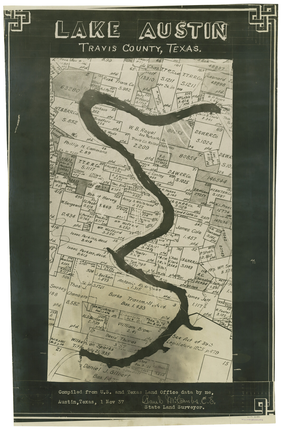
Lake Austin, Travis County, Texas
N-2-4a
-
Map/Doc
2056
-
Collection
General Map Collection
-
Object Dates
1937/11/1 (Creation Date)
-
People and Organizations
Paul McCombs (Compiler)
-
Counties
Travis
-
Subjects
River Surveys
-
Height x Width
24.8 x 16.4 inches
63.0 x 41.7 cm
-
Comments
Note on sketch: "Compiled from U. S. and Texas Land Office data".
Part of: General Map Collection
Montgomery County Sketch File 34
![31904, Montgomery County Sketch File 34, General Map Collection](https://historictexasmaps.com/wmedia_w700/pdf_converted_jpg/qi_pdf_thumbnail_13172.jpg)
Print $8.00
- Digital $50.00
Montgomery County Sketch File 34
1949
Size 14.4 x 8.7 inches
Map/Doc 31904
Flight Mission No. DAG-23K, Frame 21, Matagorda County
![86483, Flight Mission No. DAG-23K, Frame 21, Matagorda County, General Map Collection](https://historictexasmaps.com/wmedia_w700/pdf_converted_jpg/qi_pdf_thumbnail_33627.jpg)
Print $20.00
- Digital $50.00
Flight Mission No. DAG-23K, Frame 21, Matagorda County
1953
Size 18.4 x 22.3 inches
Map/Doc 86483
Hutchinson County Sketch File 19
![27234, Hutchinson County Sketch File 19, General Map Collection](https://historictexasmaps.com/wmedia_w700/pdf_converted_jpg/qi_pdf_thumbnail_12121.jpg)
Print $16.00
- Digital $50.00
Hutchinson County Sketch File 19
1913
Size 8.0 x 5.2 inches
Map/Doc 27234
Terrell County Rolled Sketch 38
![7942, Terrell County Rolled Sketch 38, General Map Collection](https://historictexasmaps.com/wmedia_w700/maps/7942.tif.jpg)
Print $20.00
- Digital $50.00
Terrell County Rolled Sketch 38
Size 22.7 x 18.0 inches
Map/Doc 7942
Flight Mission No. CRC-5R, Frame 42, Chambers County
![84961, Flight Mission No. CRC-5R, Frame 42, Chambers County, General Map Collection](https://historictexasmaps.com/wmedia_w700/pdf_converted_jpg/qi_pdf_thumbnail_32173.jpg)
Print $20.00
- Digital $50.00
Flight Mission No. CRC-5R, Frame 42, Chambers County
1956
Size 18.6 x 22.3 inches
Map/Doc 84961
Coleman County Working Sketch 12
![68078, Coleman County Working Sketch 12, General Map Collection](https://historictexasmaps.com/wmedia_w700/maps/68078.tif.jpg)
Print $20.00
- Digital $50.00
Coleman County Working Sketch 12
Size 25.7 x 26.2 inches
Map/Doc 68078
Matagorda County Rolled Sketch 9
![6680, Matagorda County Rolled Sketch 9, General Map Collection](https://historictexasmaps.com/wmedia_w700/maps/6680.tif.jpg)
Print $20.00
- Digital $50.00
Matagorda County Rolled Sketch 9
Size 36.8 x 30.0 inches
Map/Doc 6680
Brewster County Sketch File 21
![10980, Brewster County Sketch File 21, General Map Collection](https://historictexasmaps.com/wmedia_w700/pdf_converted_jpg/qi_pdf_thumbnail_7551.jpg)
Print $40.00
- Digital $50.00
Brewster County Sketch File 21
Size 23.1 x 18.9 inches
Map/Doc 10980
Briscoe County Working Sketch 4
![67807, Briscoe County Working Sketch 4, General Map Collection](https://historictexasmaps.com/wmedia_w700/maps/67807.tif.jpg)
Print $20.00
- Digital $50.00
Briscoe County Working Sketch 4
Size 26.6 x 22.7 inches
Map/Doc 67807
Young County Sketch File 16
![40880, Young County Sketch File 16, General Map Collection](https://historictexasmaps.com/wmedia_w700/pdf_converted_jpg/qi_pdf_thumbnail_15217.jpg)
Print $4.00
- Digital $50.00
Young County Sketch File 16
1896
Size 10.3 x 8.5 inches
Map/Doc 40880
Knox County Sketch File 1-1a
![29212, Knox County Sketch File 1-1a, General Map Collection](https://historictexasmaps.com/wmedia_w700/pdf_converted_jpg/qi_pdf_thumbnail_12502.jpg)
Print $30.00
- Digital $50.00
Knox County Sketch File 1-1a
1872
Size 8.2 x 12.4 inches
Map/Doc 29212
You may also like
Missouri Pacific Railway System
![89223, Missouri Pacific Railway System, General Map Collection](https://historictexasmaps.com/wmedia_w700/maps/89223.tif.jpg)
Print $20.00
- Digital $50.00
Missouri Pacific Railway System
1888
Size 20.0 x 20.0 inches
Map/Doc 89223
Sketch of H. & T. C. RR. Co. Lands on the Canadian River in Oldham and Wheeler Districts
![93193, Sketch of H. & T. C. RR. Co. Lands on the Canadian River in Oldham and Wheeler Districts, Twichell Survey Records](https://historictexasmaps.com/wmedia_w700/maps/93193.tif.jpg)
Print $40.00
- Digital $50.00
Sketch of H. & T. C. RR. Co. Lands on the Canadian River in Oldham and Wheeler Districts
1884
Size 88.9 x 23.8 inches
Map/Doc 93193
Aransas County Rolled Sketch 28
![77496, Aransas County Rolled Sketch 28, General Map Collection](https://historictexasmaps.com/wmedia_w700/maps/77496.tif.jpg)
Print $20.00
- Digital $50.00
Aransas County Rolled Sketch 28
1987
Size 24.5 x 30.9 inches
Map/Doc 77496
A Part of Blocks 31 and 32 Township 5 North
![92458, A Part of Blocks 31 and 32 Township 5 North, Twichell Survey Records](https://historictexasmaps.com/wmedia_w700/maps/92458.tif.jpg)
Print $20.00
- Digital $50.00
A Part of Blocks 31 and 32 Township 5 North
Size 19.6 x 23.8 inches
Map/Doc 92458
Fort Bend County Working Sketch 22
![69228, Fort Bend County Working Sketch 22, General Map Collection](https://historictexasmaps.com/wmedia_w700/maps/69228.tif.jpg)
Print $20.00
- Digital $50.00
Fort Bend County Working Sketch 22
Size 37.4 x 37.3 inches
Map/Doc 69228
J.K Gill & Cos Map of Oregon
![94055, J.K Gill & Cos Map of Oregon, Rees-Jones Digital Map Collection](https://historictexasmaps.com/wmedia_w700/maps/94055.tif.jpg)
Print $20.00
- Digital $50.00
J.K Gill & Cos Map of Oregon
1882
Size 29.0 x 32.3 inches
Map/Doc 94055
Flight Mission No. BRA-8M, Frame 65, Jefferson County
![85585, Flight Mission No. BRA-8M, Frame 65, Jefferson County, General Map Collection](https://historictexasmaps.com/wmedia_w700/pdf_converted_jpg/qi_pdf_thumbnail_32783.jpg)
Print $20.00
- Digital $50.00
Flight Mission No. BRA-8M, Frame 65, Jefferson County
1953
Size 18.6 x 22.4 inches
Map/Doc 85585
Hutchinson County Working Sketch 22
![66382, Hutchinson County Working Sketch 22, General Map Collection](https://historictexasmaps.com/wmedia_w700/maps/66382.tif.jpg)
Print $40.00
- Digital $50.00
Hutchinson County Working Sketch 22
Size 67.9 x 35.5 inches
Map/Doc 66382
Garza County Sketch File E
![11552, Garza County Sketch File E, General Map Collection](https://historictexasmaps.com/wmedia_w700/pdf_converted_jpg/qi_pdf_thumbnail_7992.jpg)
Print $20.00
- Digital $50.00
Garza County Sketch File E
Size 16.0 x 15.7 inches
Map/Doc 11552
El Paso County Boundary File 17
![53192, El Paso County Boundary File 17, General Map Collection](https://historictexasmaps.com/wmedia_w700/pdf_converted_jpg/qi_pdf_thumbnail_15987.jpg)
Print $8.00
- Digital $50.00
El Paso County Boundary File 17
Size 13.4 x 8.4 inches
Map/Doc 53192
Castro County Working Sketch 5
![67900, Castro County Working Sketch 5, General Map Collection](https://historictexasmaps.com/wmedia_w700/maps/67900.tif.jpg)
Print $20.00
- Digital $50.00
Castro County Working Sketch 5
Size 11.9 x 18.3 inches
Map/Doc 67900
Denton County Boundary File 3
![52424, Denton County Boundary File 3, General Map Collection](https://historictexasmaps.com/wmedia_w700/pdf_converted_jpg/qi_pdf_thumbnail_15879.jpg)
Print $34.00
- Digital $50.00
Denton County Boundary File 3
Size 6.1 x 3.9 inches
Map/Doc 52424