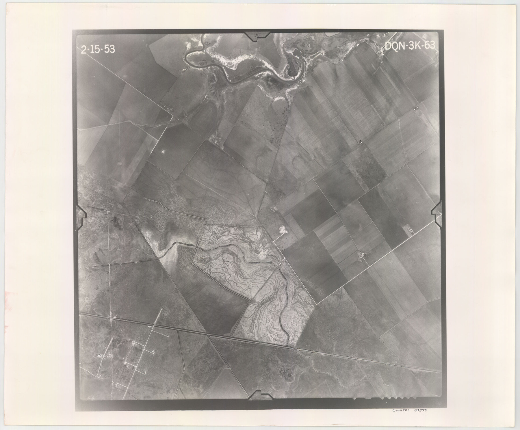
Flight Mission No. DQN-3K, Frame 63, Calhoun County
DQN-3K-53
-
Map/Doc
84354
-
Collection
General Map Collection
-
Object Dates
1953/2/15 (Creation Date)
-
People and Organizations
U. S. Department of Agriculture (Publisher)
-
Counties
Calhoun
-
Subjects
Aerial Photograph
-
Height x Width
18.4 x 22.3 inches
46.7 x 56.6 cm
-
Comments
Flown by Aero Exploration Company of Tulsa, Oklahoma.
Part of: General Map Collection
Menard County Sketch File 15

Print $8.00
- Digital $50.00
Menard County Sketch File 15
1892
Size 12.9 x 8.3 inches
Map/Doc 31510
Donley County Rolled Sketch 3

Print $20.00
- Digital $50.00
Donley County Rolled Sketch 3
1946
Size 15.1 x 21.9 inches
Map/Doc 5729
Atascosa County Rolled Sketch 14

Print $20.00
- Digital $50.00
Atascosa County Rolled Sketch 14
1944
Size 37.1 x 46.0 inches
Map/Doc 8430
Presidio County Rolled Sketch 82

Print $20.00
- Digital $50.00
Presidio County Rolled Sketch 82
1943
Size 35.5 x 26.1 inches
Map/Doc 7369
Map of Freeport, Brazoria County, Texas

Print $20.00
- Digital $50.00
Map of Freeport, Brazoria County, Texas
Size 27.0 x 39.1 inches
Map/Doc 7689
Grayson County Working Sketch 25
Print $20.00
- Digital $50.00
Grayson County Working Sketch 25
1979
Size 34.8 x 35.0 inches
Map/Doc 63264
Denton County Sketch File AB

Print $8.00
- Digital $50.00
Denton County Sketch File AB
1896
Size 7.8 x 6.9 inches
Map/Doc 20677
Clay County Sketch File 34

Print $4.00
- Digital $50.00
Clay County Sketch File 34
Size 9.6 x 7.4 inches
Map/Doc 18461
Chambers County Sketch File 40

Print $35.00
- Digital $50.00
Chambers County Sketch File 40
1925
Size 14.0 x 8.5 inches
Map/Doc 17677
Cooke County Sketch File 7

Print $8.00
- Digital $50.00
Cooke County Sketch File 7
1855
Size 10.8 x 8.3 inches
Map/Doc 19231
Crockett County Working Sketch 13

Print $20.00
- Digital $50.00
Crockett County Working Sketch 13
1916
Size 16.6 x 18.5 inches
Map/Doc 68346
Somervell County Sketch File 5

Print $95.00
- Digital $50.00
Somervell County Sketch File 5
1871
Size 8.8 x 7.7 inches
Map/Doc 36802
You may also like
Flight Mission No. BQR-9K, Frame 16, Brazoria County

Print $20.00
- Digital $50.00
Flight Mission No. BQR-9K, Frame 16, Brazoria County
1952
Size 18.8 x 22.5 inches
Map/Doc 84045
Karte von Texas entworfen nach den Vermessungen welche in den Acten der General Land Office der Republic liegen bis zum Jahr 1839

Print $20.00
- Digital $50.00
Karte von Texas entworfen nach den Vermessungen welche in den Acten der General Land Office der Republic liegen bis zum Jahr 1839
Size 18.6 x 14.1 inches
Map/Doc 96629
Atascosa County Working Sketch 4

Print $20.00
- Digital $50.00
Atascosa County Working Sketch 4
1913
Size 16.8 x 15.0 inches
Map/Doc 67199
Castro County Rolled Sketch 13A

Print $20.00
- Digital $50.00
Castro County Rolled Sketch 13A
1967
Size 20.0 x 18.9 inches
Map/Doc 5423
Map of Jefferson County Texas

Print $20.00
- Digital $50.00
Map of Jefferson County Texas
1879
Size 23.3 x 20.6 inches
Map/Doc 3729
Fort Bend County Working Sketch 32

Print $20.00
- Digital $50.00
Fort Bend County Working Sketch 32
2000
Size 36.5 x 42.5 inches
Map/Doc 69238
Bexar County Rolled Sketch 3

Print $20.00
- Digital $50.00
Bexar County Rolled Sketch 3
1873
Size 25.5 x 18.0 inches
Map/Doc 5136
[3KA and vicinity]
![90846, [3KA and vicinity], Twichell Survey Records](https://historictexasmaps.com/wmedia_w700/maps/90846-2.tif.jpg)
Print $20.00
- Digital $50.00
[3KA and vicinity]
Size 32.9 x 10.3 inches
Map/Doc 90846
Schleicher County Rolled Sketch 21

Print $20.00
- Digital $50.00
Schleicher County Rolled Sketch 21
1959
Size 47.4 x 31.5 inches
Map/Doc 9907
Bexar County Sketch File 9

Print $4.00
- Digital $50.00
Bexar County Sketch File 9
1853
Size 8.2 x 13.2 inches
Map/Doc 14479
Briscoe County Working Sketch 6

Print $20.00
- Digital $50.00
Briscoe County Working Sketch 6
1940
Size 31.0 x 24.5 inches
Map/Doc 67809
Wise County Sketch File 41

Print $4.00
- Digital $50.00
Wise County Sketch File 41
1875
Size 12.8 x 8.1 inches
Map/Doc 40599