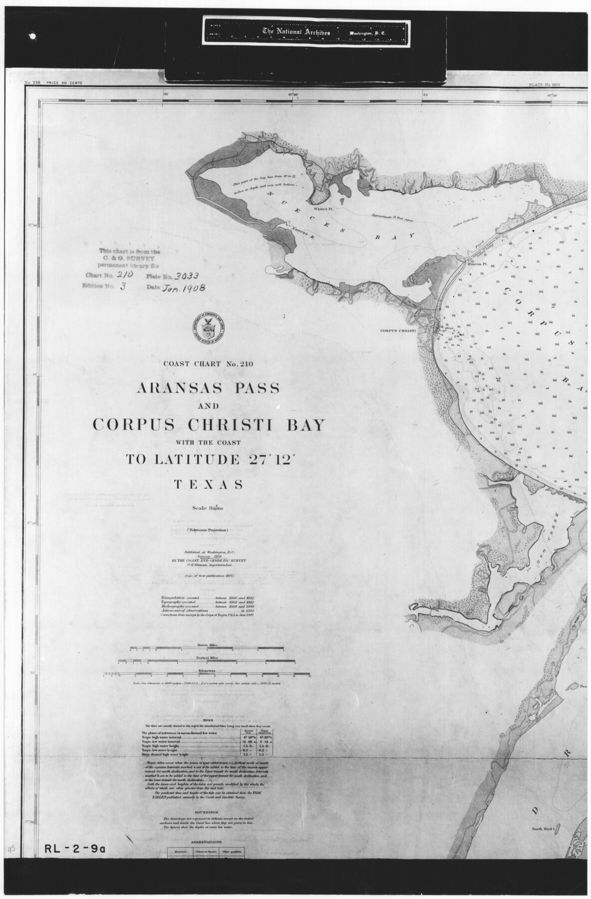
Coast Chart No. 210 Aransas Pass and Corpus Christi Bay with the coast to latitude 27° 12' Texas
RL-2-9a
-
Map/Doc
72785
-
Collection
General Map Collection
-
Object Dates
1887 (Creation Date)
-
People and Organizations
Coast and Geodetic Survey (Publisher)
-
Counties
Nueces
-
Subjects
Nautical Charts
-
Height x Width
27.6 x 18.2 inches
70.1 x 46.2 cm
-
Comments
B/W photostat copy from National Archives in multiple pieces.
Part of: General Map Collection
Flight Mission No. BRA-3M, Frame 193, Jefferson County

Print $20.00
- Digital $50.00
Flight Mission No. BRA-3M, Frame 193, Jefferson County
1953
Size 18.6 x 22.3 inches
Map/Doc 85408
Edwards County Sketch File 12

Print $16.00
- Digital $50.00
Edwards County Sketch File 12
Size 14.6 x 9.1 inches
Map/Doc 21690
PSL Field Notes for Blocks B14 and B16 in Crane and Ector Counties, Blocks B18 and B20 in Crane and Ward Counties, and Blocks B17, B21, B22, B23, B24, B25, and B26 in Crane County

PSL Field Notes for Blocks B14 and B16 in Crane and Ector Counties, Blocks B18 and B20 in Crane and Ward Counties, and Blocks B17, B21, B22, B23, B24, B25, and B26 in Crane County
Map/Doc 81646
Intracoastal Waterway - Laguna Madre - Chubby Island to Stover Point including the Arroyo Colorado, Texas

Print $20.00
- Digital $50.00
Intracoastal Waterway - Laguna Madre - Chubby Island to Stover Point including the Arroyo Colorado, Texas
1976
Size 16.0 x 43.9 inches
Map/Doc 75901
Tom Green County Sketch File 37

Print $2.00
- Digital $50.00
Tom Green County Sketch File 37
Size 9.4 x 8.5 inches
Map/Doc 38195
Armstrong County Sketch File A-7

Print $40.00
- Digital $50.00
Armstrong County Sketch File A-7
Size 15.0 x 20.4 inches
Map/Doc 10848

Gillespie County

Print $40.00
- Digital $50.00
Gillespie County
1945
Size 41.0 x 50.0 inches
Map/Doc 95507
Gregg County Rolled Sketch 9

Print $20.00
- Digital $50.00
Gregg County Rolled Sketch 9
1933
Size 38.0 x 29.8 inches
Map/Doc 6034
Cass County Sketch File 5 1/2

Print $4.00
- Digital $50.00
Cass County Sketch File 5 1/2
1851
Size 6.1 x 8.5 inches
Map/Doc 17404
Houston County Sketch File 12

Print $4.00
- Digital $50.00
Houston County Sketch File 12
1849
Size 8.2 x 14.7 inches
Map/Doc 26773
Outer Continental Shelf Leasing Maps (Louisiana Offshore Operations)

Print $20.00
- Digital $50.00
Outer Continental Shelf Leasing Maps (Louisiana Offshore Operations)
1959
Size 18.1 x 14.3 inches
Map/Doc 76110
You may also like
Montgomery County Rolled Sketch 26A

Print $20.00
- Digital $50.00
Montgomery County Rolled Sketch 26A
1941
Size 29.1 x 38.8 inches
Map/Doc 6809
A Geographically Correct Map of the State of Texas

Print $20.00
- Digital $50.00
A Geographically Correct Map of the State of Texas
1878
Size 19.5 x 21.0 inches
Map/Doc 95757
Carte d'Amerique, Divisee en ses Principaux Pays, Dressee sur les Memoires les plus recents, et sur differents Voyages, et assujettie aux observations Astronomiques de Mrs. de l'Academie Royale des Sciences

Print $40.00
- Digital $50.00
Carte d'Amerique, Divisee en ses Principaux Pays, Dressee sur les Memoires les plus recents, et sur differents Voyages, et assujettie aux observations Astronomiques de Mrs. de l'Academie Royale des Sciences
1787
Size 43.5 x 51.3 inches
Map/Doc 96430
Hemphill County Working Sketch 21

Print $40.00
- Digital $50.00
Hemphill County Working Sketch 21
1973
Size 79.0 x 32.6 inches
Map/Doc 66116
Maps of Gulf Intracoastal Waterway, Texas - Sabine River to the Rio Grande and connecting waterways including ship channels

Print $20.00
- Digital $50.00
Maps of Gulf Intracoastal Waterway, Texas - Sabine River to the Rio Grande and connecting waterways including ship channels
1966
Size 14.6 x 22.2 inches
Map/Doc 61970
Upshur County Sketch File 1

Print $9.00
- Digital $50.00
Upshur County Sketch File 1
1854
Size 5.5 x 4.5 inches
Map/Doc 38728
Part of Garza, Crosby, Lynn and Lubbock Counties

Print $20.00
- Digital $50.00
Part of Garza, Crosby, Lynn and Lubbock Counties
1912
Size 24.6 x 19.8 inches
Map/Doc 90907
Kaufman County Boundary File 2

Print $22.00
- Digital $50.00
Kaufman County Boundary File 2
Size 14.1 x 8.6 inches
Map/Doc 55911
Midland County Working Sketch 21

Print $40.00
- Digital $50.00
Midland County Working Sketch 21
1956
Size 69.0 x 27.9 inches
Map/Doc 71002
Profitable Products of East Texas, Orchards and Gardens

Profitable Products of East Texas, Orchards and Gardens
1910
Map/Doc 96775
[Caddo Lake & Subdivisions]
![2896, [Caddo Lake & Subdivisions], General Map Collection](https://historictexasmaps.com/wmedia_w700/maps/2896-1.tif.jpg)
Print $20.00
- Digital $50.00
[Caddo Lake & Subdivisions]
1918
Size 31.3 x 28.6 inches
Map/Doc 2896
University Land, El Paso County

Print $20.00
- Digital $50.00
University Land, El Paso County
1906
Size 25.1 x 31.4 inches
Map/Doc 2428