Gaines County Sketch File 21
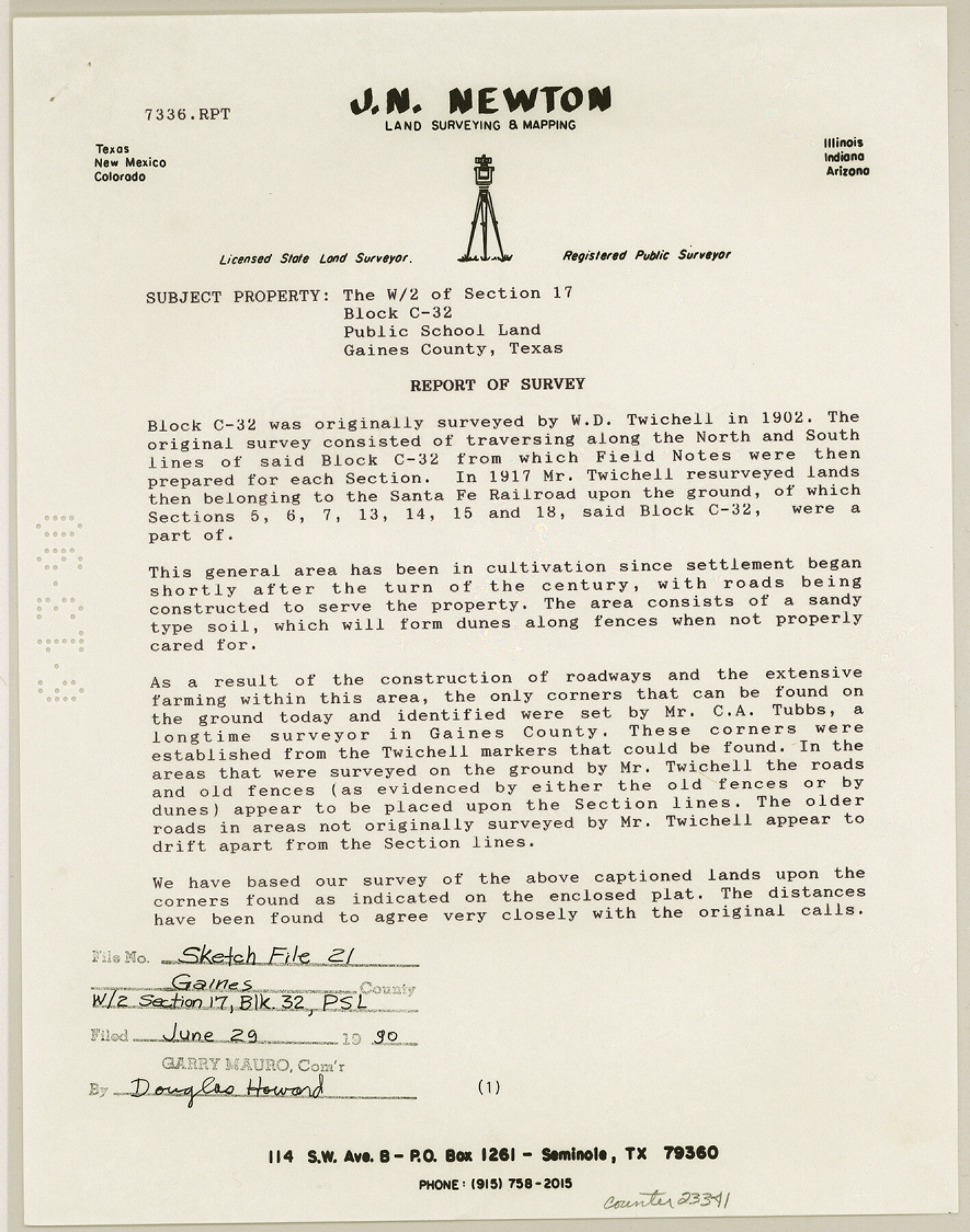
[Survey report on the west half of section 17, Block C-32, PSL]
-
Map/Doc
23341
-
Collection
General Map Collection
-
Object Dates
1990/5/23 (Creation Date)
1990/6/29 (File Date)
1902 (Survey Date)
1917 (Survey Date)
1940 (Survey Date)
1976 (Survey Date)
-
People and Organizations
J.N. Newton (Surveyor/Engineer)
W.D. Twichell (Surveyor/Engineer)
C.A. Tubbs (Surveyor/Engineer)
George Green (Surveyor/Engineer)
A.L. Harris (Surveyor/Engineer)
-
Counties
Gaines
-
Subjects
Surveying Sketch File
-
Height x Width
11.2 x 8.8 inches
28.4 x 22.4 cm
-
Medium
paper, print
-
Comments
See Gaines County Rolled Sketch 29 (5942) for sketch.
Related maps
Gaines County Rolled Sketch 29

Print $20.00
- Digital $50.00
Gaines County Rolled Sketch 29
1990
Size 14.7 x 20.5 inches
Map/Doc 5942
Part of: General Map Collection
Mississippi River to Galveston

Print $40.00
- Digital $50.00
Mississippi River to Galveston
1973
Size 37.2 x 51.2 inches
Map/Doc 69946
Walker County Working Sketch 8

Print $20.00
- Digital $50.00
Walker County Working Sketch 8
1935
Size 40.8 x 41.7 inches
Map/Doc 72288
Matagorda County NRC Article 33.136 Sketch 17

Print $24.00
Matagorda County NRC Article 33.136 Sketch 17
2023
Map/Doc 97274
McLennan County

Print $20.00
- Digital $50.00
McLennan County
1872
Size 16.3 x 21.9 inches
Map/Doc 3863
Wilbarger County Working Sketch 2a

Print $20.00
- Digital $50.00
Wilbarger County Working Sketch 2a
1922
Size 19.6 x 19.8 inches
Map/Doc 72539
Waller County Sketch File 5

Print $6.00
- Digital $50.00
Waller County Sketch File 5
Size 10.7 x 14.1 inches
Map/Doc 39600
Houston Dis. Cochino Bayou

Print $2.00
- Digital $50.00
Houston Dis. Cochino Bayou
1847
Size 11.3 x 8.2 inches
Map/Doc 184
Hutchinson County Rolled Sketch 44-13

Print $20.00
- Digital $50.00
Hutchinson County Rolled Sketch 44-13
2002
Size 24.0 x 36.0 inches
Map/Doc 77549
Comanche County Sketch File 20

Print $40.00
- Digital $50.00
Comanche County Sketch File 20
Size 15.5 x 12.6 inches
Map/Doc 19103
Galveston County NRC Article 33.136 Sketch 27

Print $126.00
- Digital $50.00
Galveston County NRC Article 33.136 Sketch 27
2003
Size 24.4 x 36.2 inches
Map/Doc 81970
Reeves County

Print $40.00
- Digital $50.00
Reeves County
1903
Size 48.7 x 36.5 inches
Map/Doc 16798
Tarrant County Rolled Sketch 4

Print $20.00
- Digital $50.00
Tarrant County Rolled Sketch 4
Size 27.0 x 18.9 inches
Map/Doc 7911
You may also like
Harris County Boundary File 39

Print $40.00
- Digital $50.00
Harris County Boundary File 39
Size 9.1 x 3.9 inches
Map/Doc 54306

Sutton County Sketch File 18

Print $94.00
- Digital $50.00
Sutton County Sketch File 18
1893
Size 12.9 x 8.3 inches
Map/Doc 37410
Wilbarger County Sketch File 6

Print $6.00
- Digital $50.00
Wilbarger County Sketch File 6
1874
Size 12.6 x 7.8 inches
Map/Doc 40172
University Lands, Blocks 34 to 37, Terrell County

Print $20.00
- Digital $50.00
University Lands, Blocks 34 to 37, Terrell County
1938
Size 32.5 x 40.0 inches
Map/Doc 2417

Hays County Sketch File 15

Print $40.00
- Digital $50.00
Hays County Sketch File 15
1871
Size 12.0 x 16.6 inches
Map/Doc 26225
Flight Mission No. CRC-3R, Frame 106, Chambers County

Print $20.00
- Digital $50.00
Flight Mission No. CRC-3R, Frame 106, Chambers County
1956
Size 18.8 x 22.6 inches
Map/Doc 84844
Montague County Sketch File 12

Print $4.00
- Digital $50.00
Montague County Sketch File 12
Size 11.4 x 8.2 inches
Map/Doc 31736
Aransas County Rolled Sketch 27E

Print $20.00
- Digital $50.00
Aransas County Rolled Sketch 27E
1958
Size 30.2 x 30.9 inches
Map/Doc 8419
Maverick County Sketch File 11

Print $40.00
- Digital $50.00
Maverick County Sketch File 11
1879
Size 8.3 x 8.8 inches
Map/Doc 31092
Webb County Sketch File 8-1

Print $20.00
- Digital $50.00
Webb County Sketch File 8-1
1929
Size 38.3 x 31.1 inches
Map/Doc 10429