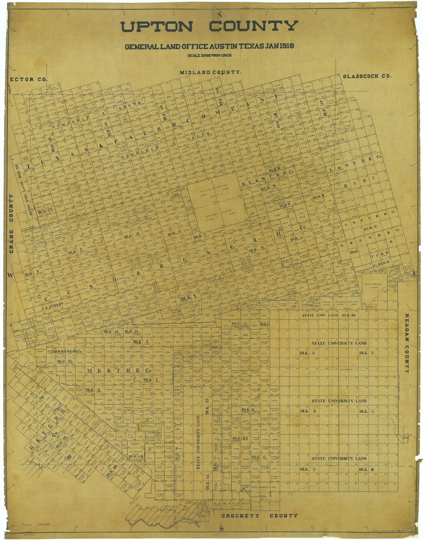
Upton County
-
Map/Doc
63089
-
Collection
General Map Collection
-
Object Dates
1918 (Creation Date)
-
People and Organizations
Texas General Land Office (Publisher)
Tom G. Atlee (Draftsman)
Tom G. Atlee (Compiler)
-
Counties
Upton
-
Subjects
County
-
Height x Width
53.9 x 42.2 inches
136.9 x 107.2 cm
-
Comments
Traced in October 1931 by W. M. Beck.
Part of: General Map Collection
Foard County Rolled Sketch 14 1/2

Print $20.00
- Digital $50.00
Foard County Rolled Sketch 14 1/2
1888
Size 20.8 x 37.4 inches
Map/Doc 5889
Harris County Working Sketch 46

Print $20.00
- Digital $50.00
Harris County Working Sketch 46
1942
Size 19.8 x 17.7 inches
Map/Doc 65938
Lubbock County Sketch File 7

Print $8.00
- Digital $50.00
Lubbock County Sketch File 7
1906
Size 7.4 x 8.5 inches
Map/Doc 30422
Chambers County Working Sketch 22

Print $20.00
- Digital $50.00
Chambers County Working Sketch 22
1978
Size 29.2 x 35.7 inches
Map/Doc 68005
[Corpus Christi Bay, Padre Island, Mustang Island, Laguna de la Madre, King and Kenedy's Pasture]
![73047, [Corpus Christi Bay, Padre Island, Mustang Island, Laguna de la Madre, King and Kenedy's Pasture], General Map Collection](https://historictexasmaps.com/wmedia_w700/maps/73047.tif.jpg)
Print $20.00
- Digital $50.00
[Corpus Christi Bay, Padre Island, Mustang Island, Laguna de la Madre, King and Kenedy's Pasture]
Size 18.2 x 26.0 inches
Map/Doc 73047
Flight Mission No. CLL-3N, Frame 31, Willacy County

Print $20.00
- Digital $50.00
Flight Mission No. CLL-3N, Frame 31, Willacy County
1954
Size 18.5 x 22.2 inches
Map/Doc 87087
[Sketch for Mineral Application 24072, San Jacinto River]
![65596, [Sketch for Mineral Application 24072, San Jacinto River], General Map Collection](https://historictexasmaps.com/wmedia_w700/maps/65596.tif.jpg)
Print $20.00
- Digital $50.00
[Sketch for Mineral Application 24072, San Jacinto River]
1929
Size 24.5 x 18.5 inches
Map/Doc 65596
Jeff Davis County Working Sketch 37

Print $20.00
- Digital $50.00
Jeff Davis County Working Sketch 37
1979
Size 31.6 x 36.6 inches
Map/Doc 66532
Henderson County Working Sketch 24

Print $20.00
- Digital $50.00
Henderson County Working Sketch 24
1952
Size 29.3 x 22.9 inches
Map/Doc 66157
Map of Bexar County

Print $20.00
- Digital $50.00
Map of Bexar County
1878
Size 24.5 x 27.6 inches
Map/Doc 3298
Part of Harris County

Print $20.00
- Digital $50.00
Part of Harris County
1876
Size 24.5 x 35.3 inches
Map/Doc 1479
Houston County Working Sketch 20

Print $20.00
- Digital $50.00
Houston County Working Sketch 20
1979
Size 26.7 x 24.0 inches
Map/Doc 66250
You may also like
[Gulf, Colorado & Santa Fe]
![64592, [Gulf, Colorado & Santa Fe], General Map Collection](https://historictexasmaps.com/wmedia_w700/maps/64592.tif.jpg)
Print $40.00
- Digital $50.00
[Gulf, Colorado & Santa Fe]
1918
Size 33.2 x 110.5 inches
Map/Doc 64592
Current Miscellaneous File 119

Print $10.00
- Digital $50.00
Current Miscellaneous File 119
1990
Size 8.5 x 10.9 inches
Map/Doc 83397
Flight Mission No. DQN-1K, Frame 50, Calhoun County

Print $20.00
- Digital $50.00
Flight Mission No. DQN-1K, Frame 50, Calhoun County
1953
Size 18.7 x 22.3 inches
Map/Doc 84150
Galveston County NRC Article 33.136 Sketch 81

Print $202.00
- Digital $50.00
Galveston County NRC Article 33.136 Sketch 81
2015
Size 34.0 x 22.0 inches
Map/Doc 94976
[Map of Texas and Pacific Blocks from Brazos River westward through Palo Pinto, Stephens, Shackelford, Jones, Callahan, Taylor, Fisher, Nolan and Mitchell Counties]
![93457, [Map of Texas and Pacific Blocks from Brazos River westward through Palo Pinto, Stephens, Shackelford, Jones, Callahan, Taylor, Fisher, Nolan and Mitchell Counties], General Map Collection](https://historictexasmaps.com/wmedia_w700/maps/93457-1.tif.jpg)
Print $20.00
- Digital $50.00
[Map of Texas and Pacific Blocks from Brazos River westward through Palo Pinto, Stephens, Shackelford, Jones, Callahan, Taylor, Fisher, Nolan and Mitchell Counties]
Size 35.0 x 19.3 inches
Map/Doc 93457
Cottle County

Print $20.00
- Digital $50.00
Cottle County
1971
Size 43.4 x 36.0 inches
Map/Doc 95467
Van Zandt County Sketch File 14

Print $4.00
- Digital $50.00
Van Zandt County Sketch File 14
1858
Size 7.9 x 8.1 inches
Map/Doc 39404
Coke County Rolled Sketch 22

Print $20.00
- Digital $50.00
Coke County Rolled Sketch 22
1957
Size 18.2 x 22.6 inches
Map/Doc 5523
Sutton County Working Sketch 57

Print $20.00
- Digital $50.00
Sutton County Working Sketch 57
1958
Size 37.7 x 32.9 inches
Map/Doc 62400
Bowie County Rolled Sketch 5

Print $20.00
- Digital $50.00
Bowie County Rolled Sketch 5
Size 33.1 x 44.5 inches
Map/Doc 8457
Taylor County Sketch File 15

Print $12.00
- Digital $50.00
Taylor County Sketch File 15
1881
Size 10.1 x 8.1 inches
Map/Doc 37805
Crockett County Working Sketch 25

Print $20.00
- Digital $50.00
Crockett County Working Sketch 25
1921
Size 23.5 x 17.6 inches
Map/Doc 68358