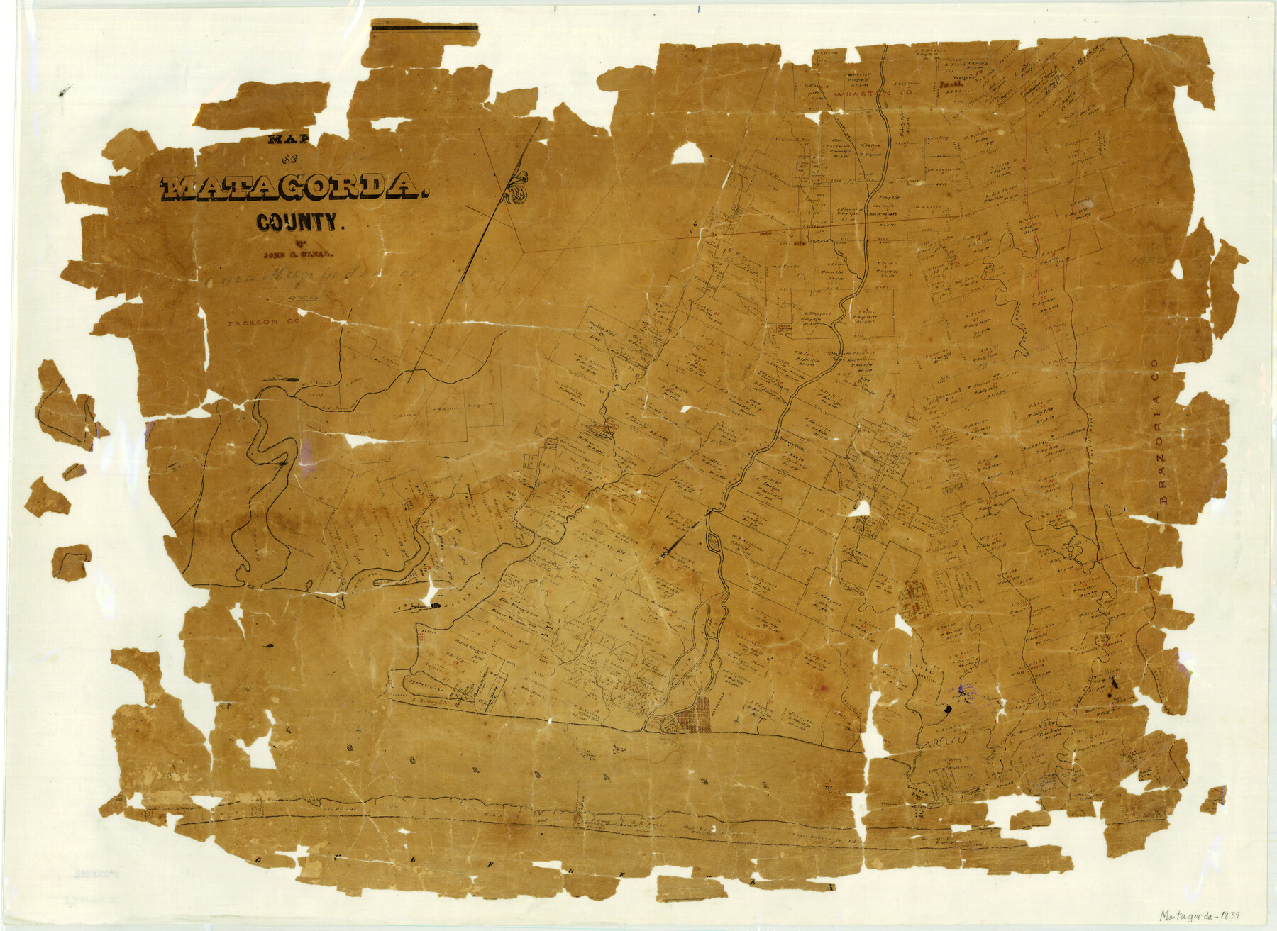
Map of Matagorda County
-
Map/Doc
3844
-
Collection
General Map Collection
-
Object Dates
1839 (Creation Date)
-
People and Organizations
Texas General Land Office (Publisher)
John G. Clead (Compiler)
John G. Clead (Draftsman)
-
Counties
Matagorda
-
Subjects
County
-
Height x Width
23.5 x 32.2 inches
59.7 x 81.8 cm
-
Features
Austin
Prairie Creek
Cedar Lake Bayou
Caney Bayou
Live Oak Bayou
Canoe Bayou
Lake Austin
Wm. Selvirk's Islands
Matagorda
Oyster Lake
Palacios
Troy Creek
Matagorda Bay
Dog Island
Deer Creek
Dressing Point
Live Oak Bay
Peace Slough
Gulf of Mexico
Post-Oak Creek
Cottonwood Creek
Tarillo Creek
Trespalacios Bayou
Preston
HT&B
Blue Creek
West Branch of Carancahua Bay
East Carancawa [sic] Creek
Juanita Creek
Trespalacios Creek
Jennings Creek
Long Pine Creek
Elliott's Ferry
Jones Creek
Linvill's Bayou
Buck Bayou
Snow's Ferry
Colorado River
Willson's Creek
Turtle Creek
Carancawa [sic] Bay
Turtle Bay
Trespalacios Bay
Part of: General Map Collection
Duval County Rolled Sketch 30

Print $20.00
- Digital $50.00
Duval County Rolled Sketch 30
1947
Size 15.8 x 27.8 inches
Map/Doc 5747
Map of Austin Co.

Print $40.00
- Digital $50.00
Map of Austin Co.
1895
Size 49.3 x 43.6 inches
Map/Doc 4795
[Ft. W. & R. G. Ry. Right of Way Map, Chapin to Bluffdale, Hood County, Texas]
![64646, [Ft. W. & R. G. Ry. Right of Way Map, Chapin to Bluffdale, Hood County, Texas], General Map Collection](https://historictexasmaps.com/wmedia_w700/maps/64646.tif.jpg)
Print $40.00
- Digital $50.00
[Ft. W. & R. G. Ry. Right of Way Map, Chapin to Bluffdale, Hood County, Texas]
1918
Size 36.8 x 69.7 inches
Map/Doc 64646
Map of Permanent Lakes & Marshes in Calhoun, Victoria & Jackson Counties for Mineral Development

Print $20.00
- Digital $50.00
Map of Permanent Lakes & Marshes in Calhoun, Victoria & Jackson Counties for Mineral Development
1937
Size 31.3 x 37.2 inches
Map/Doc 3021
Val Verde County Sketch File 21A

Print $20.00
- Digital $50.00
Val Verde County Sketch File 21A
Size 25.9 x 43.8 inches
Map/Doc 10419
Map of Maverick County

Print $20.00
- Digital $50.00
Map of Maverick County
1875
Size 36.3 x 23.7 inches
Map/Doc 3849
Stephens County Working Sketch 34

Print $20.00
- Digital $50.00
Stephens County Working Sketch 34
1978
Size 33.5 x 28.3 inches
Map/Doc 63977
Flight Mission No. CLL-1N, Frame 87, Willacy County

Print $20.00
- Digital $50.00
Flight Mission No. CLL-1N, Frame 87, Willacy County
1954
Size 18.3 x 22.0 inches
Map/Doc 87033
Burnet County Working Sketch 17

Print $20.00
- Digital $50.00
Burnet County Working Sketch 17
1979
Size 41.1 x 34.4 inches
Map/Doc 67860
Reconnaissance of the Coast of Texas between Matagorda and Corpus Christi Bays

Print $20.00
- Digital $50.00
Reconnaissance of the Coast of Texas between Matagorda and Corpus Christi Bays
1858
Size 25.2 x 21.4 inches
Map/Doc 75987
Edwards County Working Sketch 55

Print $20.00
- Digital $50.00
Edwards County Working Sketch 55
1951
Size 27.1 x 21.6 inches
Map/Doc 68931
Runnels County Sketch File 35

Print $20.00
Runnels County Sketch File 35
1889
Size 17.7 x 30.6 inches
Map/Doc 12266
You may also like
Flight Mission No. BQY-4M, Frame 61, Harris County

Print $20.00
- Digital $50.00
Flight Mission No. BQY-4M, Frame 61, Harris County
1953
Size 18.7 x 22.5 inches
Map/Doc 85270
Wilson County

Print $40.00
- Digital $50.00
Wilson County
1921
Size 39.6 x 48.5 inches
Map/Doc 73327
Crockett County Rolled Sketch 68

Print $20.00
- Digital $50.00
Crockett County Rolled Sketch 68
1947
Size 25.8 x 38.7 inches
Map/Doc 5611
Hutchinson County Sketch File 22

Print $4.00
- Digital $50.00
Hutchinson County Sketch File 22
1906
Size 13.0 x 8.5 inches
Map/Doc 27243
Gregg County Working Sketch 24

Print $20.00
- Digital $50.00
Gregg County Working Sketch 24
1985
Size 26.6 x 16.3 inches
Map/Doc 63291
Parker County Sketch File 3a

Print $40.00
- Digital $50.00
Parker County Sketch File 3a
Size 12.7 x 12.8 inches
Map/Doc 33523
Burleson County Working Sketch 16

Print $3.00
- Digital $50.00
Burleson County Working Sketch 16
1980
Size 10.1 x 14.1 inches
Map/Doc 67735
Nautical Chart 885-SC Intracoastal Waterway - Ellender to Galveston Bay, Louisiana-Texas

Print $40.00
- Digital $50.00
Nautical Chart 885-SC Intracoastal Waterway - Ellender to Galveston Bay, Louisiana-Texas
1972
Size 16.4 x 60.1 inches
Map/Doc 69835
Sketch showing Damon's Mound and adjacent surveys

Print $20.00
- Digital $50.00
Sketch showing Damon's Mound and adjacent surveys
Size 19.4 x 17.7 inches
Map/Doc 90218
Red River County, Texas

Print $20.00
Red River County, Texas
1870
Size 22.4 x 17.3 inches
Map/Doc 88989
Hutchinson County Rolled Sketch 39

Print $20.00
- Digital $50.00
Hutchinson County Rolled Sketch 39
1956
Size 29.5 x 32.1 inches
Map/Doc 7712
Winkler County Rolled Sketch 12

Print $20.00
- Digital $50.00
Winkler County Rolled Sketch 12
1965
Size 24.9 x 18.5 inches
Map/Doc 8279