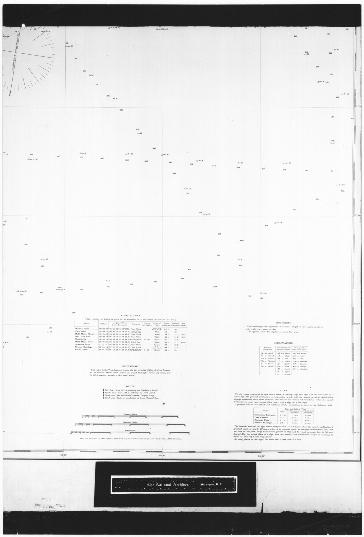
General Chart of the Coast No. XVI - Gulf Coast from Galveston to the Rio Grande
RL-2-3a
-
Map/Doc
72736
-
Collection
General Map Collection
-
Object Dates
1883 (Creation Date)
-
People and Organizations
U. S. Coast and Geodetic Survey (Publisher)
-
Subjects
Nautical Charts
-
Height x Width
26.8 x 18.2 inches
68.1 x 46.2 cm
-
Comments
B/W photostat copy from National Archives in multiple pieces.
Part of: General Map Collection
Roberts County Working Sketch 25

Print $20.00
- Digital $50.00
Roberts County Working Sketch 25
1982
Size 23.0 x 20.4 inches
Map/Doc 63551
Cherokee County Sketch File 22b

Print $20.00
- Digital $50.00
Cherokee County Sketch File 22b
1906
Size 15.5 x 14.0 inches
Map/Doc 82019
Approaches to Galveston Bay

Print $40.00
- Digital $50.00
Approaches to Galveston Bay
1982
Size 53.1 x 36.7 inches
Map/Doc 69884
Sketch of North Line of T&P Eighty Mile Reserve

Print $20.00
- Digital $50.00
Sketch of North Line of T&P Eighty Mile Reserve
1914
Size 43.0 x 9.8 inches
Map/Doc 2245
Plat of Resurvey of Section 36, T. 4S., R. 14W., Indian Meridian, Oklahoma

Print $4.00
- Digital $50.00
Plat of Resurvey of Section 36, T. 4S., R. 14W., Indian Meridian, Oklahoma
1917
Size 18.1 x 22.6 inches
Map/Doc 75152
Flight Mission No. CGI-1N, Frame 185, Cameron County

Print $20.00
- Digital $50.00
Flight Mission No. CGI-1N, Frame 185, Cameron County
1955
Size 18.6 x 22.2 inches
Map/Doc 84520
Flight Mission No. CUG-2P, Frame 83, Kleberg County

Print $20.00
- Digital $50.00
Flight Mission No. CUG-2P, Frame 83, Kleberg County
1956
Size 18.5 x 22.3 inches
Map/Doc 86215
Webb County Sketch File 50

Print $20.00
- Digital $50.00
Webb County Sketch File 50
1939
Size 27.4 x 18.6 inches
Map/Doc 12648
Johnson County Working Sketch 26

Print $20.00
- Digital $50.00
Johnson County Working Sketch 26
2005
Size 22.3 x 41.8 inches
Map/Doc 83574
Williamson County Sketch File 15

Print $4.00
- Digital $50.00
Williamson County Sketch File 15
Size 10.0 x 8.0 inches
Map/Doc 40334
Wichita County Sketch File 10

Print $4.00
- Digital $50.00
Wichita County Sketch File 10
Size 12.7 x 8.3 inches
Map/Doc 40054
Hamilton County Working Sketch 26

Print $20.00
- Digital $50.00
Hamilton County Working Sketch 26
1964
Size 22.8 x 29.6 inches
Map/Doc 63364
You may also like
[Sketch of Surveys on San Antonio Road]
![41, [Sketch of Surveys on San Antonio Road], General Map Collection](https://historictexasmaps.com/wmedia_w700/maps/41.tif.jpg)
Print $20.00
- Digital $50.00
[Sketch of Surveys on San Antonio Road]
1840
Size 20.6 x 15.4 inches
Map/Doc 41
Sabine County Working Sketch 6

Print $20.00
- Digital $50.00
Sabine County Working Sketch 6
1918
Size 17.5 x 17.6 inches
Map/Doc 63677
Chambers County Sketch File 27

Print $12.00
- Digital $50.00
Chambers County Sketch File 27
1934
Size 11.3 x 8.8 inches
Map/Doc 17606
[Part of Block GG and river sections 68 1/2 -73]
![90471, [Part of Block GG and river sections 68 1/2 -73], Twichell Survey Records](https://historictexasmaps.com/wmedia_w700/maps/90471-1.tif.jpg)
Print $20.00
- Digital $50.00
[Part of Block GG and river sections 68 1/2 -73]
Size 28.0 x 19.2 inches
Map/Doc 90471

Flight Mission No. BRA-16M, Frame 174, Jefferson County

Print $20.00
- Digital $50.00
Flight Mission No. BRA-16M, Frame 174, Jefferson County
1953
Size 18.6 x 22.4 inches
Map/Doc 85772
Upshur County Rolled Sketch 4

Print $20.00
- Digital $50.00
Upshur County Rolled Sketch 4
1972
Size 25.4 x 37.9 inches
Map/Doc 8063
Copy of Surveyor's Field Book, Morris Browning - In Blocks 7, 5 & 4, I&GNRRCo., Hutchinson and Carson Counties, Texas

Print $2.00
- Digital $50.00
Copy of Surveyor's Field Book, Morris Browning - In Blocks 7, 5 & 4, I&GNRRCo., Hutchinson and Carson Counties, Texas
1888
Size 6.9 x 8.8 inches
Map/Doc 62262
[Maps of surveys in Reeves & Culberson Cos]
![61136, [Maps of surveys in Reeves & Culberson Cos], General Map Collection](https://historictexasmaps.com/wmedia_w700/maps/61136.tif.jpg)
Print $20.00
- Digital $50.00
[Maps of surveys in Reeves & Culberson Cos]
1937
Size 30.5 x 24.7 inches
Map/Doc 61136
Andrews County Working Sketch 26

Print $20.00
- Digital $50.00
Andrews County Working Sketch 26
1983
Size 34.3 x 37.5 inches
Map/Doc 67072
Crockett County Sketch File A1, A3, D, and DA2

Print $44.00
- Digital $50.00
Crockett County Sketch File A1, A3, D, and DA2
Size 14.3 x 8.8 inches
Map/Doc 19626
Donley County Sketch File 3

Print $6.00
- Digital $50.00
Donley County Sketch File 3
Size 10.8 x 11.9 inches
Map/Doc 21217