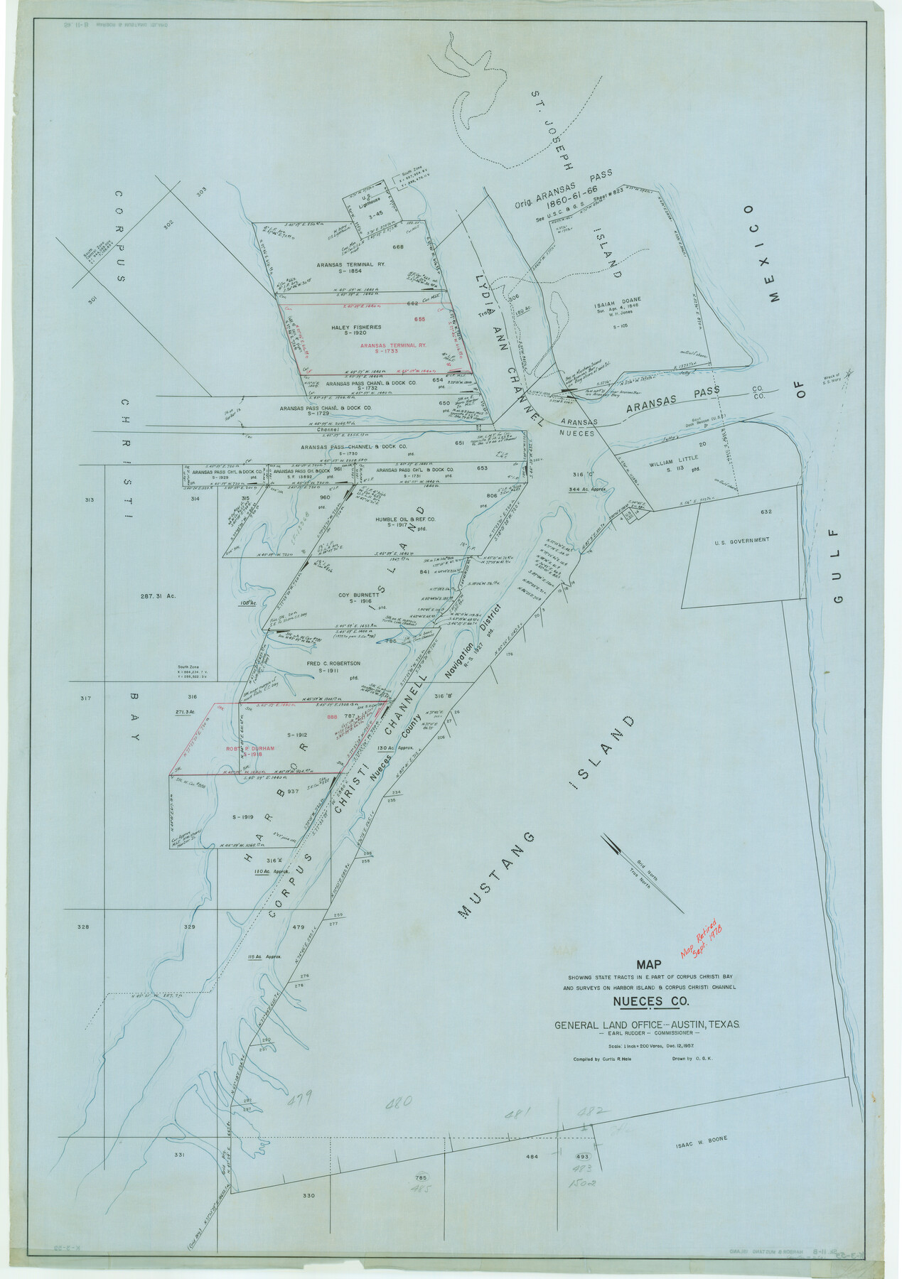
Map showing state tracts in E. part of Corpus Christi Bay and surveys on Harbor Island & Corpus Christi channel
K-3-59
-
Map/Doc
2501
-
Collection
General Map Collection
-
Object Dates
1978 (Creation Date)
-
People and Organizations
General Land Office (Publisher)
General Land Office (Author)
-
Subjects
Energy Offshore Submerged Area
-
Height x Width
53.4 x 37.7 inches
135.6 x 95.8 cm
-
Comments
Map retired in Sept. 1978.
Part of: General Map Collection
Castro County Sketch File 1

Print $6.00
- Digital $50.00
Castro County Sketch File 1
1890
Size 8.8 x 7.8 inches
Map/Doc 17451
Bosque County Working Sketch Graphic Index

Print $20.00
- Digital $50.00
Bosque County Working Sketch Graphic Index
1945
Size 46.9 x 36.5 inches
Map/Doc 76469
Gonzales County

Print $20.00
- Digital $50.00
Gonzales County
1880
Size 26.5 x 23.4 inches
Map/Doc 4549
Oldham County Working Sketch 11

Print $20.00
- Digital $50.00
Oldham County Working Sketch 11
2014
Size 26.6 x 32.7 inches
Map/Doc 93686
Runnels County Rolled Sketch 53

Print $20.00
- Digital $50.00
Runnels County Rolled Sketch 53
Size 33.1 x 31.1 inches
Map/Doc 7538
Nueces County Rolled Sketch 113A

Print $20.00
- Digital $50.00
Nueces County Rolled Sketch 113A
1972
Size 19.1 x 24.4 inches
Map/Doc 7121
Central Part of Jeff Davis Co.

Print $40.00
- Digital $50.00
Central Part of Jeff Davis Co.
1982
Size 55.4 x 43.9 inches
Map/Doc 73193
Mosaic composed of aerial photographs - Houston Ship Channel, Tex.

Print $20.00
- Digital $50.00
Mosaic composed of aerial photographs - Houston Ship Channel, Tex.
1923
Size 13.7 x 38.0 inches
Map/Doc 97172
[Right of Way Map, Belton Branch of the M.K.&T. RR.]
![64227, [Right of Way Map, Belton Branch of the M.K.&T. RR.], General Map Collection](https://historictexasmaps.com/wmedia_w700/maps/64227.tif.jpg)
Print $20.00
- Digital $50.00
[Right of Way Map, Belton Branch of the M.K.&T. RR.]
1896
Size 22.0 x 7.2 inches
Map/Doc 64227
Henderson County Boundary File 43

Print $28.00
- Digital $50.00
Henderson County Boundary File 43
Size 5.0 x 8.3 inches
Map/Doc 54708
DeWitt County Working Sketch 15

Print $20.00
- Digital $50.00
DeWitt County Working Sketch 15
1991
Size 30.0 x 42.1 inches
Map/Doc 68605

You may also like
Midland County Working Sketch Graphic Index

Print $20.00
- Digital $50.00
Midland County Working Sketch Graphic Index
1930
Size 43.3 x 35.3 inches
Map/Doc 76641
Map Showing Block HG and Connecting Surveys

Print $2.00
- Digital $50.00
Map Showing Block HG and Connecting Surveys
1907
Size 9.2 x 13.7 inches
Map/Doc 90681
Map of Callahan County, Texas

Print $20.00
- Digital $50.00
Map of Callahan County, Texas
1879
Size 24.6 x 19.6 inches
Map/Doc 4337
Erath County Sketch File 8

Print $4.00
- Digital $50.00
Erath County Sketch File 8
Size 8.6 x 13.0 inches
Map/Doc 22269
Harris County Working Sketch 18

Print $20.00
- Digital $50.00
Harris County Working Sketch 18
1919
Size 12.1 x 14.8 inches
Map/Doc 65910
Burnet County Working Sketch 12

Print $20.00
- Digital $50.00
Burnet County Working Sketch 12
1976
Size 17.3 x 19.9 inches
Map/Doc 67855
Upper Galveston Bay, Houston Ship Channel, Dollar Pt. to Atkinson I.

Print $40.00
- Digital $50.00
Upper Galveston Bay, Houston Ship Channel, Dollar Pt. to Atkinson I.
1992
Size 49.2 x 37.0 inches
Map/Doc 69899
![90327, [Block B9], Twichell Survey Records](https://historictexasmaps.com/wmedia_w700/maps/90327-1.tif.jpg)
Fisher County Sketch File Bb

Print $26.00
- Digital $50.00
Fisher County Sketch File Bb
1902
Size 14.3 x 8.7 inches
Map/Doc 22657
Galveston County Sketch File 58

Print $20.00
- Digital $50.00
Galveston County Sketch File 58
1984
Size 47.1 x 38.3 inches
Map/Doc 10458
Grayson County

Print $20.00
- Digital $50.00
Grayson County
1935
Size 43.4 x 40.5 inches
Map/Doc 95512
Eastland County Working Sketch 31

Print $20.00
- Digital $50.00
Eastland County Working Sketch 31
1955
Size 33.9 x 33.9 inches
Map/Doc 68812