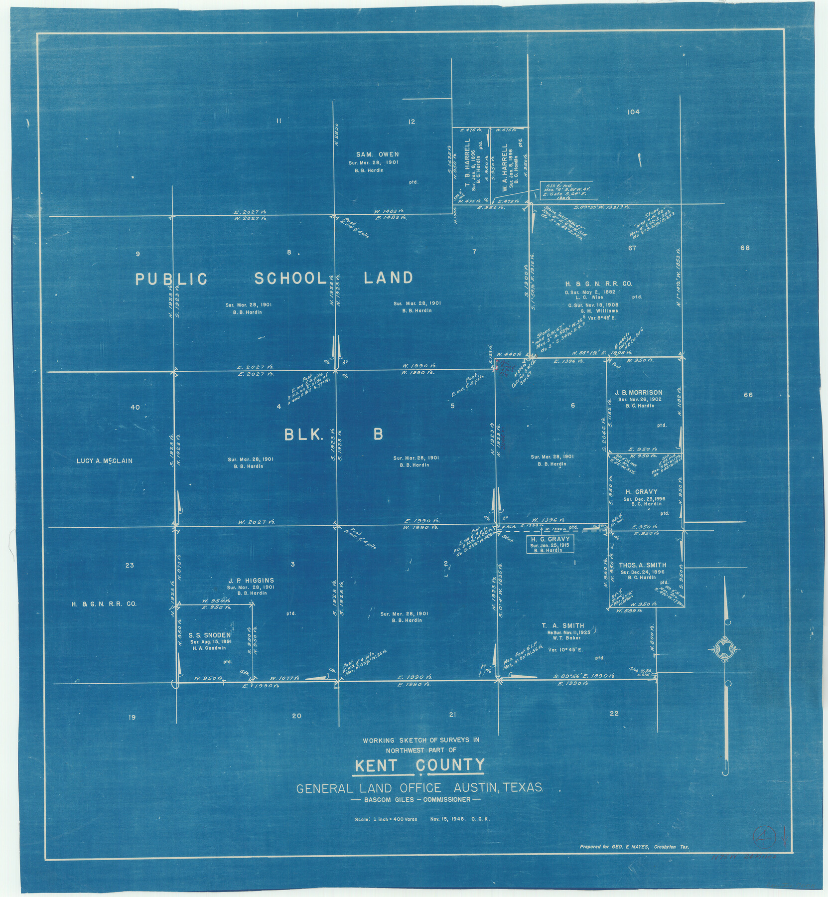
Kent County Working Sketch 4
-
Map/Doc
70011
-
Collection
General Map Collection
-
Object Dates
11/15/1948 (Creation Date)
-
People and Organizations
Otto G. Kurio (Draftsman)
-
Counties
Kent
-
Subjects
Surveying Working Sketch
-
Height x Width
27.9 x 25.8 inches
70.9 x 65.5 cm
-
Scale
1" = 400 varas
Part of: General Map Collection
Bowie County Sketch File 8f

Print $10.00
- Digital $50.00
Bowie County Sketch File 8f
1928
Size 8.1 x 5.2 inches
Map/Doc 14902
[Map of the Houston and G. N. R.R. and lands adjacent, from Troupe to the Texas Pacific R.R.]
![64628, [Map of the Houston and G. N. R.R. and lands adjacent, from Troupe to the Texas Pacific R.R.], General Map Collection](https://historictexasmaps.com/wmedia_w700/maps/64628.tif.jpg)
Print $40.00
- Digital $50.00
[Map of the Houston and G. N. R.R. and lands adjacent, from Troupe to the Texas Pacific R.R.]
1873
Size 20.2 x 49.3 inches
Map/Doc 64628
Morris County Working Sketch Graphic Index

Print $20.00
- Digital $50.00
Morris County Working Sketch Graphic Index
1948
Size 42.8 x 20.1 inches
Map/Doc 76649
Acreage in Texas Counties

Print $20.00
- Digital $50.00
Acreage in Texas Counties
1966
Size 47.1 x 25.8 inches
Map/Doc 73594
Medina County Working Sketch 9

Print $20.00
- Digital $50.00
Medina County Working Sketch 9
1959
Size 25.3 x 38.8 inches
Map/Doc 70924
Coleman County Sketch File 44

Print $17.00
- Digital $50.00
Coleman County Sketch File 44
Size 14.1 x 8.6 inches
Map/Doc 18783
Map of DeWitt County

Print $20.00
- Digital $50.00
Map of DeWitt County
1881
Size 21.7 x 24.3 inches
Map/Doc 3478
Anderson County Sketch File 2

Print $4.00
- Digital $50.00
Anderson County Sketch File 2
1847
Size 12.6 x 8.2 inches
Map/Doc 12739
Cooke County Rolled Sketch 4

Print $20.00
- Digital $50.00
Cooke County Rolled Sketch 4
Size 18.1 x 23.1 inches
Map/Doc 5562
Presidio County Working Sketch 5

Print $20.00
- Digital $50.00
Presidio County Working Sketch 5
1917
Size 14.0 x 17.5 inches
Map/Doc 71679
Morris County Rolled Sketch 2A

Print $20.00
- Digital $50.00
Morris County Rolled Sketch 2A
Size 24.0 x 18.6 inches
Map/Doc 10235
Haskell County

Print $20.00
- Digital $50.00
Haskell County
1879
Size 21.0 x 20.4 inches
Map/Doc 1127
You may also like
Webb County Working Sketch 74

Print $20.00
- Digital $50.00
Webb County Working Sketch 74
1975
Size 17.0 x 30.0 inches
Map/Doc 72441
La Salle County

Print $20.00
- Digital $50.00
La Salle County
1879
Size 27.4 x 23.6 inches
Map/Doc 3800
Foard County Sketch File 30

Print $6.00
- Digital $50.00
Foard County Sketch File 30
Size 9.1 x 8.2 inches
Map/Doc 22858
[Beaumont, Sour Lake and Western Ry. Right of Way and Alignment - Frisco]
![64131, [Beaumont, Sour Lake and Western Ry. Right of Way and Alignment - Frisco], General Map Collection](https://historictexasmaps.com/wmedia_w700/maps/64131.tif.jpg)
Print $20.00
- Digital $50.00
[Beaumont, Sour Lake and Western Ry. Right of Way and Alignment - Frisco]
1910
Size 20.3 x 46.2 inches
Map/Doc 64131
Austin County Sketch File 18

Print $14.00
- Digital $50.00
Austin County Sketch File 18
Size 12.8 x 8.2 inches
Map/Doc 13927
Flight Mission No. CUG-1P, Frame 71, Kleberg County

Print $20.00
- Digital $50.00
Flight Mission No. CUG-1P, Frame 71, Kleberg County
1956
Size 18.5 x 22.2 inches
Map/Doc 86136
Freestone County Sketch File 14

Print $4.00
- Digital $50.00
Freestone County Sketch File 14
1861
Size 13.0 x 8.2 inches
Map/Doc 23065
Presidio County Rolled Sketch 53

Print $20.00
- Digital $50.00
Presidio County Rolled Sketch 53
1911
Size 13.0 x 22.2 inches
Map/Doc 7346
The Cotton Kingdom: a Traveller's Observations on Cotton and Slavery in the American Slave States

The Cotton Kingdom: a Traveller's Observations on Cotton and Slavery in the American Slave States
Map/Doc 96571

Dallam County Boundary File 3

Print $40.00
- Digital $50.00
Dallam County Boundary File 3
Size 9.3 x 4.1 inches
Map/Doc 52062
Childress County Rolled Sketch 8C

Print $20.00
- Digital $50.00
Childress County Rolled Sketch 8C
Size 23.5 x 21.0 inches
Map/Doc 5445