Jackson County Rolled Sketch 10
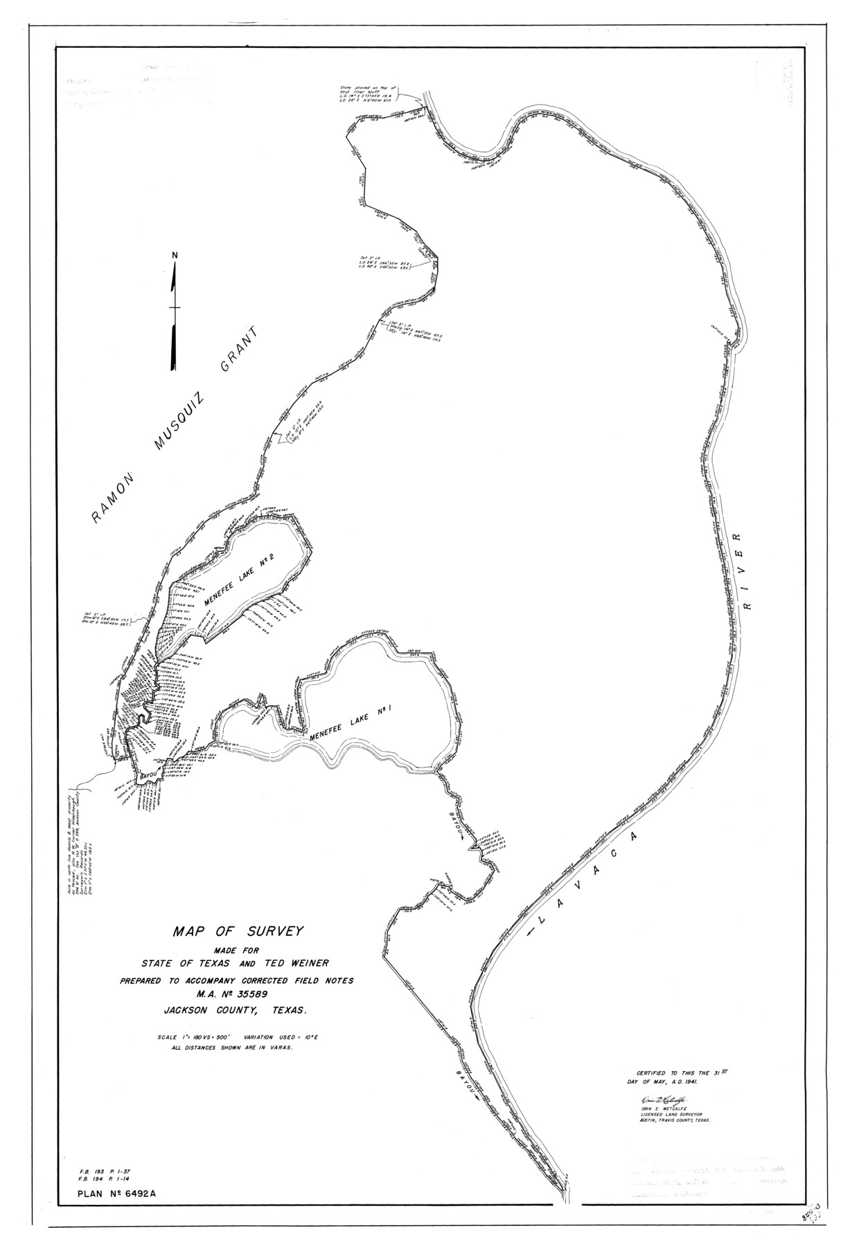
Map of survey made for State of Texas and Ted Weiner prepared to accompany corrected field notes M.A. No. 35589, Jackson County, Texas
-
Map/Doc
9259
-
Collection
General Map Collection
-
Object Dates
1941/6/6 (File Date)
1941/5/31 (Creation Date)
-
People and Organizations
Orin E. Metcalfe (Surveyor/Engineer)
-
Counties
Jackson
-
Subjects
Surveying Rolled Sketch
-
Height x Width
47.1 x 32.5 inches
119.6 x 82.6 cm
-
Scale
1" = 180 varas
-
Comments
See Jackson County Sketch File 30 (27730) for Final Judgement.
Related maps
Jackson County Sketch File 30

Print $52.00
- Digital $50.00
Jackson County Sketch File 30
1944
Size 14.2 x 8.5 inches
Map/Doc 27730
Part of: General Map Collection
Amistad International Reservoir on Rio Grande 71

Print $20.00
- Digital $50.00
Amistad International Reservoir on Rio Grande 71
1949
Size 28.3 x 39.5 inches
Map/Doc 73358
Lamar [County]
![3787, Lamar [County], General Map Collection](https://historictexasmaps.com/wmedia_w700/maps/3787.tif.jpg)
Print $40.00
- Digital $50.00
Lamar [County]
1889
Size 48.2 x 35.7 inches
Map/Doc 3787
Coleman County Working Sketch 19

Print $20.00
- Digital $50.00
Coleman County Working Sketch 19
1953
Size 18.1 x 15.4 inches
Map/Doc 68085
Wilson County Working Sketch 6

Print $20.00
- Digital $50.00
Wilson County Working Sketch 6
1955
Size 39.4 x 32.3 inches
Map/Doc 72586
Caddo Lake and Subdivision

Print $20.00
- Digital $50.00
Caddo Lake and Subdivision
1918
Size 35.0 x 29.8 inches
Map/Doc 93283
Flight Mission No. CUG-1P, Frame 76, Kleberg County

Print $20.00
- Digital $50.00
Flight Mission No. CUG-1P, Frame 76, Kleberg County
1956
Size 18.6 x 22.3 inches
Map/Doc 86141
Fisher County Sketch File Bb

Print $26.00
- Digital $50.00
Fisher County Sketch File Bb
1902
Size 14.3 x 8.7 inches
Map/Doc 22657
Cameron County Rolled Sketch 23

Print $17.00
- Digital $50.00
Cameron County Rolled Sketch 23
Size 10.0 x 15.2 inches
Map/Doc 43931
Martin County Boundary File 62a

Print $30.00
- Digital $50.00
Martin County Boundary File 62a
Size 12.8 x 8.3 inches
Map/Doc 56801

[Maps of surveys in Reeves & Culberson Cos]
![61147, [Maps of surveys in Reeves & Culberson Cos], General Map Collection](https://historictexasmaps.com/wmedia_w700/maps/61147.tif.jpg)
Print $20.00
- Digital $50.00
[Maps of surveys in Reeves & Culberson Cos]
1937
Size 30.6 x 24.9 inches
Map/Doc 61147
Brewster County Sketch File FN-34

Print $40.00
- Digital $50.00
Brewster County Sketch File FN-34
1943
Size 23.1 x 27.1 inches
Map/Doc 10984
You may also like
Aransas County Rolled Sketch 20

Print $20.00
- Digital $50.00
Aransas County Rolled Sketch 20
Size 43.2 x 47.3 inches
Map/Doc 8414
Pecos County Rolled Sketch 25B

Print $20.00
- Digital $50.00
Pecos County Rolled Sketch 25B
1892
Size 22.2 x 16.0 inches
Map/Doc 7210
Harris County Rolled Sketch 88

Print $20.00
- Digital $50.00
Harris County Rolled Sketch 88
1934
Size 35.2 x 23.2 inches
Map/Doc 6120
Williamson County Rolled Sketch 3

Print $20.00
- Digital $50.00
Williamson County Rolled Sketch 3
1915
Size 40.1 x 30.9 inches
Map/Doc 8261
Brazos River, East Waco Sheet

Print $6.00
- Digital $50.00
Brazos River, East Waco Sheet
1928
Size 31.6 x 25.9 inches
Map/Doc 65283
Burnet County Rolled Sketch T

Print $20.00
- Digital $50.00
Burnet County Rolled Sketch T
Size 24.9 x 18.5 inches
Map/Doc 76053
[C.C.S.D. & R.G.N.G. RR. Co. Blk. G east thru T.&P. Blk 33]
![89777, [C.C.S.D. & R.G.N.G. RR. Co. Blk. G east thru T.&P. Blk 33], Twichell Survey Records](https://historictexasmaps.com/wmedia_w700/maps/89777-1.tif.jpg)
Print $40.00
- Digital $50.00
[C.C.S.D. & R.G.N.G. RR. Co. Blk. G east thru T.&P. Blk 33]
1901
Size 69.8 x 24.3 inches
Map/Doc 89777
Hudspeth County Rolled Sketch 32

Print $40.00
- Digital $50.00
Hudspeth County Rolled Sketch 32
Size 32.7 x 94.9 inches
Map/Doc 9211
[Northeast 1/4 of County]
![91629, [Northeast 1/4 of County], Twichell Survey Records](https://historictexasmaps.com/wmedia_w700/maps/91629-1.tif.jpg)
Print $2.00
- Digital $50.00
[Northeast 1/4 of County]
Size 12.3 x 9.0 inches
Map/Doc 91629
Map of the Southern States designed to accompany Smith's Geography for Schools

Print $20.00
- Digital $50.00
Map of the Southern States designed to accompany Smith's Geography for Schools
1850
Size 12.1 x 19.2 inches
Map/Doc 93888
Kimble County Working Sketch 48

Print $20.00
- Digital $50.00
Kimble County Working Sketch 48
1951
Size 23.2 x 22.1 inches
Map/Doc 70116
Flight Mission No. DCL-4C, Frame 70, Kenedy County

Print $20.00
- Digital $50.00
Flight Mission No. DCL-4C, Frame 70, Kenedy County
1943
Size 18.7 x 22.4 inches
Map/Doc 85815