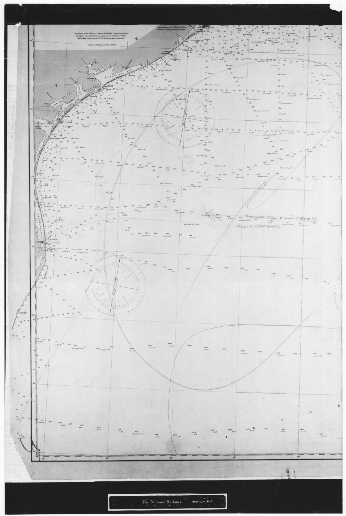
Gulf Coast of the United States, Key West to Rio Grande
RL-1-4b
-
Map/Doc
72672
-
Collection
General Map Collection
-
Object Dates
1892 (Creation Date)
-
People and Organizations
T. C. Mendehhall (Publisher)
-
Subjects
Nautical Charts
-
Height x Width
27.5 x 18.4 inches
69.9 x 46.7 cm
-
Comments
B/W photostat copy from National Archives in multiple pieces. Chart No. 5, Edition 3, Plate No. 2128, June 1892
Part of: General Map Collection

Brazoria County Working Sketch 20

Print $40.00
- Digital $50.00
Brazoria County Working Sketch 20
1951
Size 50.3 x 42.9 inches
Map/Doc 67505
Freestone County Working Sketch 9

Print $20.00
- Digital $50.00
Freestone County Working Sketch 9
1975
Size 26.3 x 38.4 inches
Map/Doc 69251
Gillespie County Working Sketch 2

Print $20.00
- Digital $50.00
Gillespie County Working Sketch 2
1958
Size 35.9 x 26.0 inches
Map/Doc 63165
Jasper County Rolled Sketch 3

Print $20.00
- Digital $50.00
Jasper County Rolled Sketch 3
1944
Size 24.5 x 43.4 inches
Map/Doc 6350
United States - Gulf Coast - From Latitude 26° 33' to the Rio Grande Texas

Print $20.00
- Digital $50.00
United States - Gulf Coast - From Latitude 26° 33' to the Rio Grande Texas
1913
Size 27.9 x 18.4 inches
Map/Doc 72834
Flight Mission No. DQN-1K, Frame 136, Calhoun County

Print $20.00
- Digital $50.00
Flight Mission No. DQN-1K, Frame 136, Calhoun County
1953
Size 18.5 x 22.3 inches
Map/Doc 84199
Webb County Rolled Sketch 49

Print $40.00
- Digital $50.00
Webb County Rolled Sketch 49
1943
Size 55.4 x 13.1 inches
Map/Doc 10124
Upton County Working Sketch 48

Print $20.00
- Digital $50.00
Upton County Working Sketch 48
1975
Size 29.3 x 24.3 inches
Map/Doc 69544
Map of Texas from the most recent authorities

Print $20.00
- Digital $50.00
Map of Texas from the most recent authorities
1845
Size 14.2 x 18.0 inches
Map/Doc 96628
Pecos County Rolled Sketch 85

Print $20.00
- Digital $50.00
Pecos County Rolled Sketch 85
1931
Size 36.7 x 24.4 inches
Map/Doc 7243
Duval County Rolled Sketch 11

Print $20.00
- Digital $50.00
Duval County Rolled Sketch 11
Size 20.4 x 30.1 inches
Map/Doc 5733
You may also like
Map of Bexar County

Print $20.00
- Digital $50.00
Map of Bexar County
1878
Size 24.5 x 27.6 inches
Map/Doc 3298
Chambers County Sketch File 51

Print $35.00
- Digital $50.00
Chambers County Sketch File 51
1935
Size 14.3 x 9.0 inches
Map/Doc 18068
Map of South America designed to accompany Smith's Geography of Schools

Print $20.00
- Digital $50.00
Map of South America designed to accompany Smith's Geography of Schools
1850
Size 12.0 x 9.8 inches
Map/Doc 93891
Harrison County Rolled Sketch 14

Print $20.00
- Digital $50.00
Harrison County Rolled Sketch 14
1968
Size 25.8 x 20.0 inches
Map/Doc 6157
Hill County Working Sketch 5

Print $20.00
- Digital $50.00
Hill County Working Sketch 5
2008
Size 32.2 x 31.6 inches
Map/Doc 89013
Lampasas County

Print $20.00
- Digital $50.00
Lampasas County
1972
Size 34.4 x 43.4 inches
Map/Doc 73214
Pecos County Boundary File 1b

Print $8.00
- Digital $50.00
Pecos County Boundary File 1b
Size 14.2 x 8.5 inches
Map/Doc 57861
Maps & Lists Showing Prison Lands (Oil & Gas) Leased as of June 1955

Print $2.00
- Digital $50.00
Maps & Lists Showing Prison Lands (Oil & Gas) Leased as of June 1955
1955
Size 11.2 x 8.8 inches
Map/Doc 62863
Terrell County Working Sketch 10

Print $20.00
- Digital $50.00
Terrell County Working Sketch 10
1924
Size 28.0 x 25.9 inches
Map/Doc 62159
San Augustine County Working Sketch 4

Print $20.00
- Digital $50.00
San Augustine County Working Sketch 4
1934
Size 24.4 x 27.7 inches
Map/Doc 63691
[Strip along North line of Glasscock County School Land]
![90556, [Strip along North line of Glasscock County School Land], Twichell Survey Records](https://historictexasmaps.com/wmedia_w700/maps/90556-1.tif.jpg)
Print $2.00
- Digital $50.00
[Strip along North line of Glasscock County School Land]
Size 4.3 x 6.5 inches
Map/Doc 90556
Galveston County NRC Article 33.136 Sketch 94

Print $72.00
Galveston County NRC Article 33.136 Sketch 94
2024
Map/Doc 97293