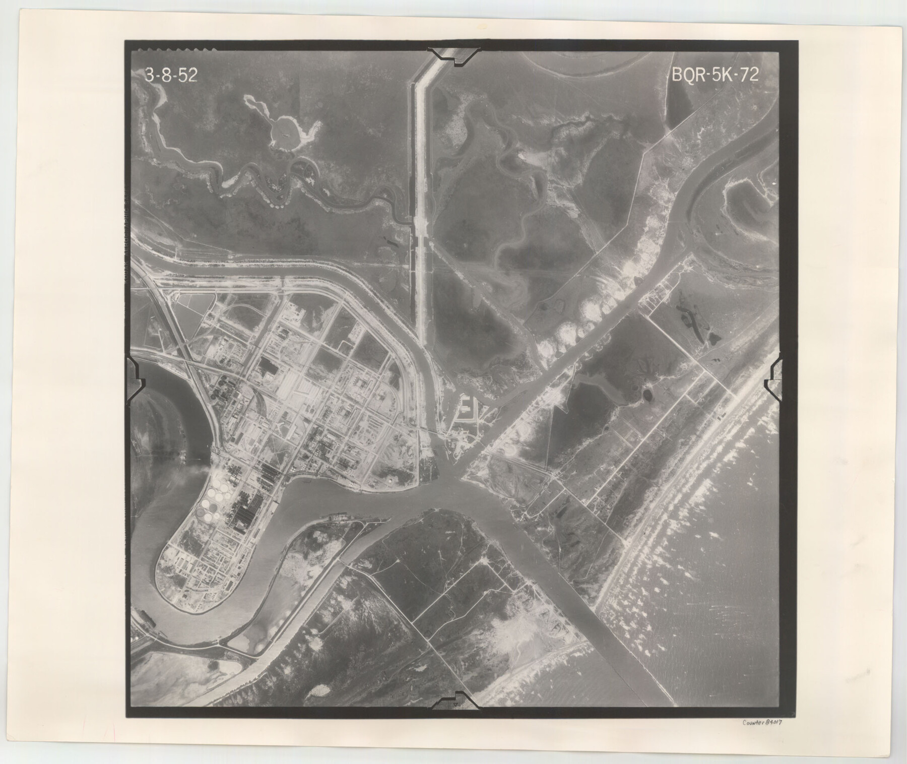
Flight Mission No. BQR-5K, Frame 72, Brazoria County
BQR-5K-72
-
Map/Doc
84017
-
Collection
General Map Collection
-
Object Dates
1952/3/8 (Creation Date)
-
People and Organizations
U. S. Department of Agriculture (Publisher)
-
Counties
Brazoria
-
Subjects
Aerial Photograph
-
Height x Width
18.9 x 22.4 inches
48.0 x 56.9 cm
-
Comments
Flown by Aero Exploration Company of Tulsa, Oklahoma.
Part of: General Map Collection
Coke County Sketch File 2

Print $22.00
- Digital $50.00
Coke County Sketch File 2
Size 9.1 x 7.8 inches
Map/Doc 18565
Aransas Pass to Baffin Bay

Print $20.00
- Digital $50.00
Aransas Pass to Baffin Bay
1992
Size 45.0 x 36.0 inches
Map/Doc 73423
Goliad County Sketch File 15

Print $4.00
- Digital $50.00
Goliad County Sketch File 15
1879
Size 8.1 x 14.9 inches
Map/Doc 24245
Hockley County Sketch File 19

Print $20.00
- Digital $50.00
Hockley County Sketch File 19
1944
Size 14.9 x 25.8 inches
Map/Doc 11775
Flight Mission No. CRC-4R, Frame 160, Chambers County

Print $20.00
- Digital $50.00
Flight Mission No. CRC-4R, Frame 160, Chambers County
1956
Size 18.5 x 22.3 inches
Map/Doc 84919
Taylor County Working Sketch 4a

Print $20.00
- Digital $50.00
Taylor County Working Sketch 4a
1944
Size 17.2 x 14.0 inches
Map/Doc 69613
Zavala County Sketch File 13

Print $4.00
- Digital $50.00
Zavala County Sketch File 13
1891
Size 14.5 x 9.0 inches
Map/Doc 41306
Montgomery County Sketch File 9

Print $6.00
- Digital $50.00
Montgomery County Sketch File 9
Size 9.0 x 7.6 inches
Map/Doc 31795
Harrison County Sketch File 19

Print $20.00
- Digital $50.00
Harrison County Sketch File 19
1954
Size 25.0 x 21.7 inches
Map/Doc 11692
Crosby County Sketch File 31

Print $20.00
- Digital $50.00
Crosby County Sketch File 31
Size 35.0 x 14.0 inches
Map/Doc 11257
Medina County Rolled Sketch 4

Print $20.00
- Digital $50.00
Medina County Rolled Sketch 4
1943
Size 20.2 x 26.4 inches
Map/Doc 6740
Chambers County NRC Article 33.136 Sketch 5

Print $22.00
- Digital $50.00
Chambers County NRC Article 33.136 Sketch 5
2003
Size 24.2 x 18.3 inches
Map/Doc 78608
You may also like
Angelina County Working Sketch 31

Print $20.00
- Digital $50.00
Angelina County Working Sketch 31
1955
Size 24.3 x 24.5 inches
Map/Doc 67113
Hood County Sketch File 23a

Print $20.00
- Digital $50.00
Hood County Sketch File 23a
1887
Size 17.2 x 16.5 inches
Map/Doc 11781
Duval County Rolled Sketch E

Print $20.00
- Digital $50.00
Duval County Rolled Sketch E
1935
Size 36.4 x 37.7 inches
Map/Doc 8808
Flight Mission No. DCL-6C, Frame 2, Kenedy County

Print $20.00
- Digital $50.00
Flight Mission No. DCL-6C, Frame 2, Kenedy County
1943
Size 18.6 x 22.4 inches
Map/Doc 85862
Brewster County Working Sketch 84

Print $20.00
- Digital $50.00
Brewster County Working Sketch 84
1973
Size 44.9 x 39.4 inches
Map/Doc 67684
Armstrong County Working Sketch 9

Print $20.00
- Digital $50.00
Armstrong County Working Sketch 9
1993
Size 40.9 x 33.6 inches
Map/Doc 67240
Tyler County Sketch File 2

Print $4.00
- Digital $50.00
Tyler County Sketch File 2
Size 6.3 x 5.6 inches
Map/Doc 38615
General Highway Map, Walker County, Texas

Print $20.00
General Highway Map, Walker County, Texas
1940
Size 24.9 x 18.4 inches
Map/Doc 79269
Current Miscellaneous File 90

Print $18.00
- Digital $50.00
Current Miscellaneous File 90
1956
Size 11.2 x 8.8 inches
Map/Doc 74255

Travis County Sketch File 10

Print $16.00
- Digital $50.00
Travis County Sketch File 10
1863
Size 7.7 x 13.7 inches
Map/Doc 38292
Sutton County Working Sketch 64

Print $20.00
- Digital $50.00
Sutton County Working Sketch 64
1963
Size 32.6 x 26.2 inches
Map/Doc 62407