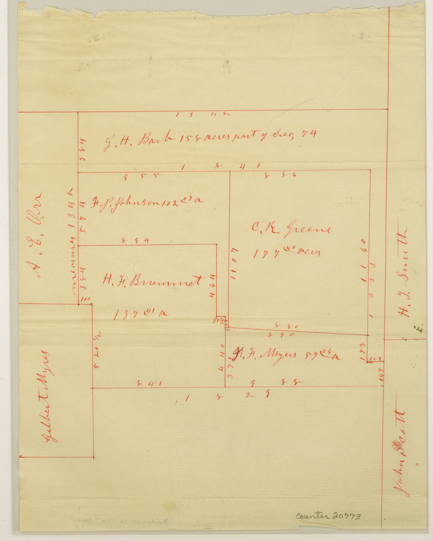
Denton County Sketch File 36a
[Sketch and explanation regarding School Land section 74]
-
Map/Doc
20773
-
Collection
General Map Collection
-
Object Dates
1898/1/25 (Creation Date)
1898/1/26 (File Date)
-
People and Organizations
Elijah Biggerstaff (Surveyor/Engineer)
-
Counties
Denton
-
Subjects
Surveying Sketch File
-
Height x Width
11.3 x 9.1 inches
28.7 x 23.1 cm
-
Medium
paper, manuscript
Part of: General Map Collection

Cameron County Boundary File 4

Print $42.00
- Digital $50.00
Cameron County Boundary File 4
Size 10.4 x 8.2 inches
Map/Doc 51110
Montague County Sketch File 27

Print $20.00
- Digital $50.00
Montague County Sketch File 27
1954
Size 15.8 x 22.5 inches
Map/Doc 12109
Flight Mission No. DAG-21K, Frame 107, Matagorda County

Print $20.00
- Digital $50.00
Flight Mission No. DAG-21K, Frame 107, Matagorda County
1952
Size 18.6 x 22.4 inches
Map/Doc 86435
Wharton County Sketch File 4b

Print $4.00
- Digital $50.00
Wharton County Sketch File 4b
1876
Size 12.7 x 8.0 inches
Map/Doc 39921
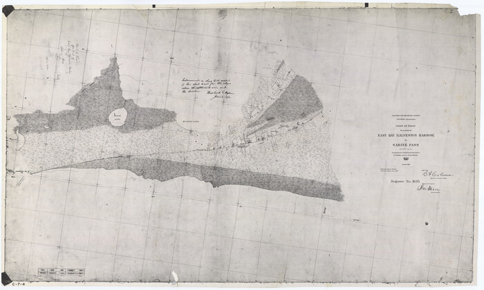
Coast of Texas from head of East Bay Galveston Harbor to Sabine Pass
Print $40.00
- Digital $50.00
Coast of Texas from head of East Bay Galveston Harbor to Sabine Pass
1882
Size 32.3 x 53.9 inches
Map/Doc 69840
Roberts County Working Sketch 39

Print $20.00
- Digital $50.00
Roberts County Working Sketch 39
1978
Size 26.6 x 22.7 inches
Map/Doc 63565
Martin County Sketch File 14

Print $46.00
- Digital $50.00
Martin County Sketch File 14
1937
Size 11.2 x 8.8 inches
Map/Doc 30671
Jack County Working Sketch 12

Print $20.00
- Digital $50.00
Jack County Working Sketch 12
1959
Size 18.0 x 22.4 inches
Map/Doc 66438
San Jacinto County Sketch File 16

Print $4.00
San Jacinto County Sketch File 16
1934
Size 11.3 x 8.7 inches
Map/Doc 35729
Presidio County Rolled Sketch 131B

Print $20.00
- Digital $50.00
Presidio County Rolled Sketch 131B
1993
Size 33.4 x 46.7 inches
Map/Doc 9803
Travis County State Real Property Sketch 5

Print $20.00
- Digital $50.00
Travis County State Real Property Sketch 5
1990
Size 25.4 x 37.5 inches
Map/Doc 61696
You may also like
Flight Mission No. DQO-7K, Frame 101, Galveston County

Print $20.00
- Digital $50.00
Flight Mission No. DQO-7K, Frame 101, Galveston County
1952
Size 18.7 x 22.6 inches
Map/Doc 85116

Chambers County Rolled Sketch 30

Print $20.00
- Digital $50.00
Chambers County Rolled Sketch 30
1952
Size 26.7 x 37.9 inches
Map/Doc 5430
Plat of Resurvey of Sections 13, 24, 25 and 26, T. 5S., R. 12W., of the Indian Meridian, Oklahoma

Print $4.00
- Digital $50.00
Plat of Resurvey of Sections 13, 24, 25 and 26, T. 5S., R. 12W., of the Indian Meridian, Oklahoma
1917
Size 18.3 x 24.1 inches
Map/Doc 75158
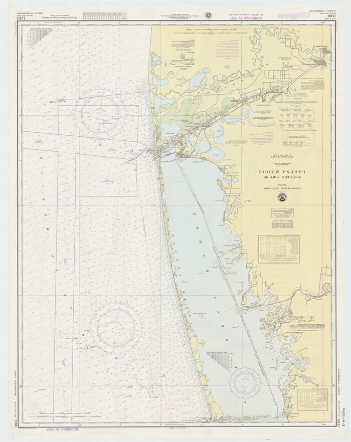
Southern Part of Laguna Madre
Print $20.00
- Digital $50.00
Southern Part of Laguna Madre
1975
Size 44.8 x 35.5 inches
Map/Doc 73544

Bastrop County

Print $20.00
- Digital $50.00
Bastrop County
1872
Size 21.1 x 17.4 inches
Map/Doc 3279
[Map of North Half of Hutchinson and South Half of Hansford Counties]
![92114, [Map of North Half of Hutchinson and South Half of Hansford Counties], Twichell Survey Records](https://historictexasmaps.com/wmedia_w700/maps/92114-1.tif.jpg)
Print $3.00
- Digital $50.00
[Map of North Half of Hutchinson and South Half of Hansford Counties]
Size 11.6 x 13.5 inches
Map/Doc 92114
Culberson County Rolled Sketch 43

Print $20.00
- Digital $50.00
Culberson County Rolled Sketch 43
1947
Size 20.5 x 36.7 inches
Map/Doc 5664
Nolan County Working Sketch 10

Print $40.00
- Digital $50.00
Nolan County Working Sketch 10
1971
Size 78.9 x 37.0 inches
Map/Doc 71301
The MKT - Texas Empire of the South

Print $20.00
- Digital $50.00
The MKT - Texas Empire of the South
1905
Size 18.6 x 40.6 inches
Map/Doc 97034
Flight Mission No. BRE-2P, Frame 138, Nueces County

Print $20.00
- Digital $50.00
Flight Mission No. BRE-2P, Frame 138, Nueces County
1956
Size 18.5 x 22.2 inches
Map/Doc 86811