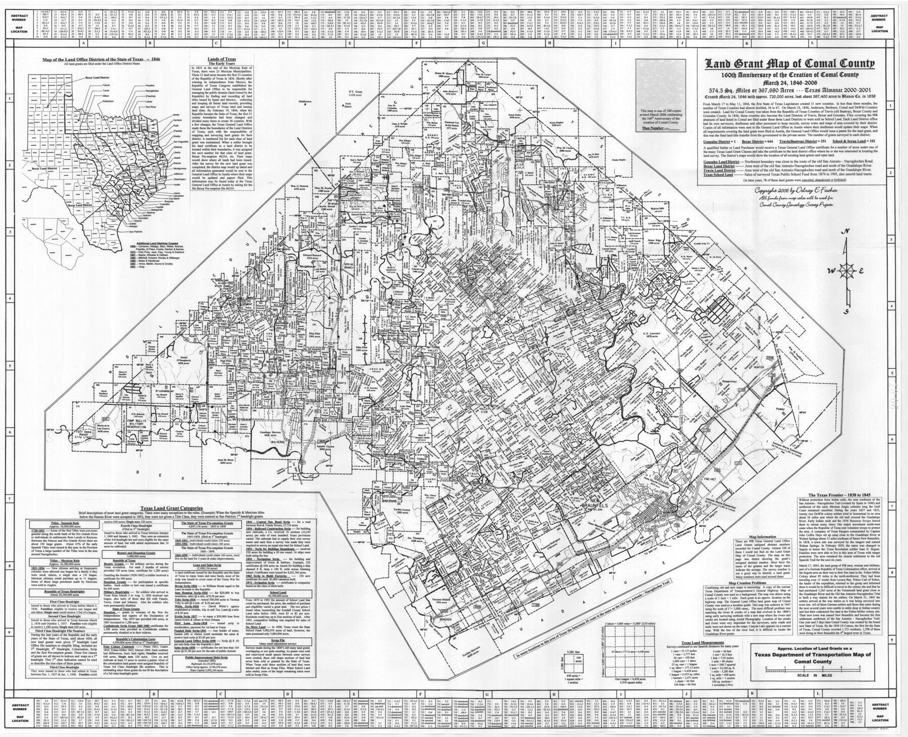
Land Grant Map of Comal County
-
Map/Doc
83601
-
Collection
General Map Collection
-
Object Dates
2006 (Creation Date)
2006/4/28 (File Date)
-
People and Organizations
Comal County Genealogy Society (Publisher)
Delray E. Fischer (Draftsman)
Delray E. Fischer (Compiler)
-
Counties
Comal
-
Subjects
County
-
Height x Width
33.3 x 41.0 inches
84.6 x 104.1 cm
-
Comments
Map issued for the 160th Anniversity of the Creation of Comal County.
Copyright 2006 by Delray E. Fisher. -
Features
Comal Creek
Alligator Creek
Deep Creek
State Highway 46
Elm Creek
Hanz Creek
Bulverde
Dripping Creek
Smithson Valley
Water Hole Creek
New Braunfels
UP
Coney Creek
Marion to McQueeney Road
Marion Road
McQueeney Road
Old San Antonio to Nacodoches Trail
Old San Antonio Trail
Nacodoches [sic] Trail
State Highway 35
Four Mile Creek
Bear Creek
Bracken
Sattler
Schultz Creek
Twin Sisters
Blanco Road
Blanco River
Dutch Branch of Blanco River
San Marcos Road
State Highway 32
Sorrel Creek
Potter Creek
State Highway 306
State Highway 484
Bermer
Middletown
State Highway 281
Spring Branch
Guadalupe River
Boerne Road
Canyon Lake Forest
State Highway 3159
State Highway 2673
Bullshead Hollow Creek
San Marcos to Austin Road
Austin Road
Part of: General Map Collection
Traced from Genl. Arista's map captured by the American Army under Genl. Taylor at Resaca de la Palma 9th May '46 and presented to James K. Polk, President U. States

Print $20.00
- Digital $50.00
Traced from Genl. Arista's map captured by the American Army under Genl. Taylor at Resaca de la Palma 9th May '46 and presented to James K. Polk, President U. States
1846
Size 18.4 x 27.6 inches
Map/Doc 73059
Chart of the West Indies and Spanish Dominions in North America

Print $20.00
- Digital $50.00
Chart of the West Indies and Spanish Dominions in North America
1803
Size 25.6 x 39.2 inches
Map/Doc 97138
Van Zandt County Sketch File 6

Print $4.00
- Digital $50.00
Van Zandt County Sketch File 6
1848
Size 9.7 x 7.9 inches
Map/Doc 39373
Galveston County Aerial Photograph Index Sheet 3

Print $20.00
- Digital $50.00
Galveston County Aerial Photograph Index Sheet 3
1953
Size 22.2 x 19.2 inches
Map/Doc 83694
La Salle County Working Sketch 52

Print $40.00
- Digital $50.00
La Salle County Working Sketch 52
1963
Size 53.5 x 43.0 inches
Map/Doc 70353
Hemphill County Rolled Sketch 10

Print $20.00
- Digital $50.00
Hemphill County Rolled Sketch 10
Size 19.4 x 27.6 inches
Map/Doc 6192
Denton County Boundary File 4 and 4a and 4b and 4c

Print $168.00
- Digital $50.00
Denton County Boundary File 4 and 4a and 4b and 4c
Size 11.1 x 8.6 inches
Map/Doc 52448
Nautical Chart 885-SC Intracoastal Waterway - Ellender to Galveston Bay, Louisiana-Texas

Print $40.00
- Digital $50.00
Nautical Chart 885-SC Intracoastal Waterway - Ellender to Galveston Bay, Louisiana-Texas
1972
Size 16.4 x 60.1 inches
Map/Doc 69835
Map of the Mississippi River from its Source to the Mouth of the Missouri

Print $20.00
- Digital $50.00
Map of the Mississippi River from its Source to the Mouth of the Missouri
1810
Size 10.4 x 31.3 inches
Map/Doc 95153
Jim Hogg County Working Sketch 7

Print $20.00
- Digital $50.00
Jim Hogg County Working Sketch 7
1964
Size 20.0 x 18.6 inches
Map/Doc 66593
Copy of Surveyor's Field Book, Morris Browning - In Blocks 7, 5 & 4, I&GNRRCo., Hutchinson and Carson Counties, Texas

Print $3.00
- Digital $50.00
Copy of Surveyor's Field Book, Morris Browning - In Blocks 7, 5 & 4, I&GNRRCo., Hutchinson and Carson Counties, Texas
1888
Size 12.7 x 9.7 inches
Map/Doc 62258
Map of Madison County

Print $20.00
- Digital $50.00
Map of Madison County
1880
Size 17.0 x 24.9 inches
Map/Doc 3832
You may also like
[Sketch showing H. & T. C. Blocks 47 and M-26]
![91698, [Sketch showing H. & T. C. Blocks 47 and M-26], Twichell Survey Records](https://historictexasmaps.com/wmedia_w700/maps/91698-1.tif.jpg)
Print $3.00
- Digital $50.00
[Sketch showing H. & T. C. Blocks 47 and M-26]
Size 9.5 x 12.0 inches
Map/Doc 91698
Map of Texas with population and location of principal towns and cities, according to latest reliable statistics

Print $20.00
- Digital $50.00
Map of Texas with population and location of principal towns and cities, according to latest reliable statistics
1906
Size 19.0 x 20.7 inches
Map/Doc 95867
Galveston County NRC Article 33.136 Sketch 60

Print $88.00
- Digital $50.00
Galveston County NRC Article 33.136 Sketch 60
2009
Size 24.0 x 36.0 inches
Map/Doc 89263
Galveston County Working Sketch 18

Print $20.00
- Digital $50.00
Galveston County Working Sketch 18
1982
Size 18.3 x 19.7 inches
Map/Doc 69355
Spanish North America

Print $20.00
- Digital $50.00
Spanish North America
1814
Size 21.9 x 29.8 inches
Map/Doc 89224
Liberty County Sketch File 32a

Print $4.00
- Digital $50.00
Liberty County Sketch File 32a
Size 9.2 x 7.6 inches
Map/Doc 29965
Comanche County Working Sketch 12

Print $20.00
- Digital $50.00
Comanche County Working Sketch 12
1957
Size 15.4 x 25.5 inches
Map/Doc 68146
Map of the City of Aransas Pass

Print $20.00
- Digital $50.00
Map of the City of Aransas Pass
1905
Size 28.3 x 21.4 inches
Map/Doc 97266
Lee County Working Sketch 15

Print $20.00
- Digital $50.00
Lee County Working Sketch 15
1981
Size 18.4 x 14.0 inches
Map/Doc 70394
El Paso County Boundary File 14

Print $8.00
- Digital $50.00
El Paso County Boundary File 14
Size 13.0 x 8.6 inches
Map/Doc 53179

The Republic County of Refugio. Proposed, Late Fall 1837

Print $20.00
The Republic County of Refugio. Proposed, Late Fall 1837
2020
Size 22.3 x 21.6 inches
Map/Doc 96256