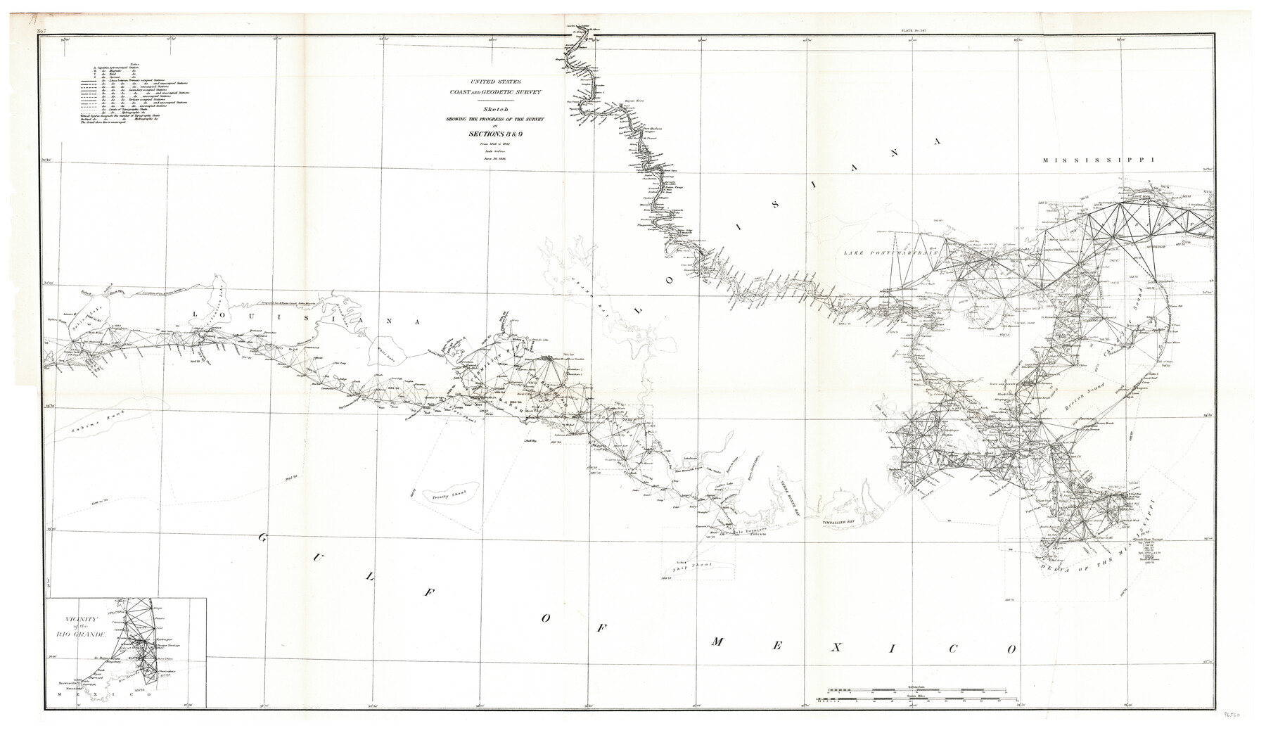
Sketch showing the progress of the survey in Sections 8 & 9 from 1846 to 1882
Inset: Vicinity of the Rio Grande
-
Map/Doc
96560
-
Collection
General Map Collection
-
Object Dates
1886/6/30 (Publication Date)
-
People and Organizations
U.S. Coast and Geodetic Survey (Publisher)
Mark Lambert (Donor)
-
Subjects
Gulf of Mexico Nautical Charts
-
Height x Width
21.8 x 37.2 inches
55.4 x 94.5 cm
-
Medium
paper, etching/engraving/lithograph
-
Comments
Donated by Mark Lambert
Part of: General Map Collection
Freestone County State of Texas

Print $20.00
- Digital $50.00
Freestone County State of Texas
1888
Size 27.2 x 21.6 inches
Map/Doc 3562
Travis County Rolled Sketch 18

Print $20.00
- Digital $50.00
Travis County Rolled Sketch 18
1940
Size 28.8 x 21.1 inches
Map/Doc 8020
Kimble County Rolled Sketch 38

Print $20.00
- Digital $50.00
Kimble County Rolled Sketch 38
1986
Size 28.3 x 21.7 inches
Map/Doc 6528
Orange County Rolled Sketch 13

Print $20.00
- Digital $50.00
Orange County Rolled Sketch 13
Size 19.0 x 24.2 inches
Map/Doc 7180
Corpus Christi Pass, Texas

Print $3.00
- Digital $50.00
Corpus Christi Pass, Texas
1869
Size 16.7 x 11.2 inches
Map/Doc 73456
Potter County Sketch File 22

Print $30.00
- Digital $50.00
Potter County Sketch File 22
1962
Size 14.2 x 8.6 inches
Map/Doc 34415
Dawson County Rolled Sketch 7

Print $20.00
- Digital $50.00
Dawson County Rolled Sketch 7
Size 18.5 x 39.3 inches
Map/Doc 5692
Flight Mission No. BRA-3M, Frame 128, Jefferson County

Print $20.00
- Digital $50.00
Flight Mission No. BRA-3M, Frame 128, Jefferson County
1953
Size 18.5 x 22.3 inches
Map/Doc 85402
Coke County Working Sketch 24

Print $20.00
- Digital $50.00
Coke County Working Sketch 24
1956
Size 28.7 x 31.1 inches
Map/Doc 68061
Mills County Boundary File 7

Print $2.00
- Digital $50.00
Mills County Boundary File 7
Size 14.2 x 8.6 inches
Map/Doc 57312
Dickens County Working Sketch 1

Print $20.00
- Digital $50.00
Dickens County Working Sketch 1
Size 15.5 x 15.5 inches
Map/Doc 68648
Right of Way & Track Map, San Antonio & Aransas Pass Railway Co.

Print $40.00
- Digital $50.00
Right of Way & Track Map, San Antonio & Aransas Pass Railway Co.
1919
Size 25.0 x 56.7 inches
Map/Doc 64215
You may also like
Menard County Boundary File 13

Print $32.00
- Digital $50.00
Menard County Boundary File 13
Size 8.9 x 9.4 inches
Map/Doc 57121
Roberts County Working Sketch 23

Print $20.00
- Digital $50.00
Roberts County Working Sketch 23
1979
Size 19.7 x 12.9 inches
Map/Doc 63549
Leon County Rolled Sketch 17

Print $20.00
- Digital $50.00
Leon County Rolled Sketch 17
Size 20.5 x 24.7 inches
Map/Doc 6603
Harris County NRC Article 33.136 Location Key Sheet

Print $20.00
- Digital $50.00
Harris County NRC Article 33.136 Location Key Sheet
1995
Size 27.0 x 21.8 inches
Map/Doc 77027
University of Texas System University Lands

Print $20.00
- Digital $50.00
University of Texas System University Lands
1938
Size 17.8 x 23.4 inches
Map/Doc 93247
Map of Nacogdoches County

Print $40.00
- Digital $50.00
Map of Nacogdoches County
1839
Size 83.6 x 41.6 inches
Map/Doc 93371
Map of Calhoun County

Print $20.00
- Digital $50.00
Map of Calhoun County
1863
Size 23.0 x 19.5 inches
Map/Doc 887
Flight Mission No. DIX-6P, Frame 130, Aransas County

Print $20.00
- Digital $50.00
Flight Mission No. DIX-6P, Frame 130, Aransas County
1956
Size 19.3 x 22.9 inches
Map/Doc 83836
Fisher County Sketch File 7

Print $4.00
- Digital $50.00
Fisher County Sketch File 7
1893
Size 14.6 x 9.1 inches
Map/Doc 22565
Jackson County Sketch File 11

Print $20.00
- Digital $50.00
Jackson County Sketch File 11
1922
Size 15.7 x 30.1 inches
Map/Doc 11837
King County Survey

Print $20.00
- Digital $50.00
King County Survey
1916
Size 25.4 x 30.1 inches
Map/Doc 91020
Presidio County Sketch File 89

Print $10.00
- Digital $50.00
Presidio County Sketch File 89
1953
Size 14.3 x 8.9 inches
Map/Doc 34756