Schleicher County Sketch File 28
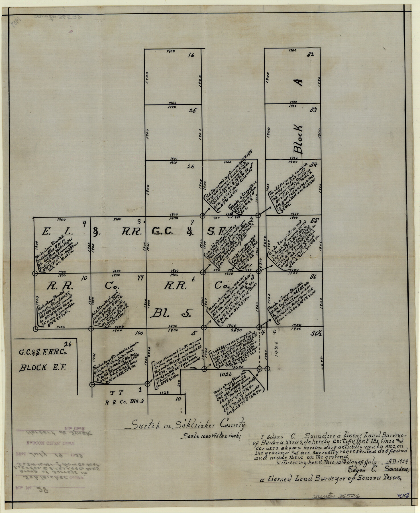
[Sketch of a group of surveys in E. L. & R. R. R.R. Co. and G. C. & S. F. R.R. Co. Block 5]
-
Map/Doc
36526
-
Collection
General Map Collection
-
Object Dates
7/14/1939 (Creation Date)
7/19/1939 (File Date)
-
People and Organizations
Edgar C. Saunders (Surveyor/Engineer)
-
Counties
Schleicher
-
Subjects
Surveying Sketch File
-
Height x Width
17.4 x 14.2 inches
44.2 x 36.1 cm
-
Medium
paper, manuscript
-
Scale
1" = 1000 varas
Part of: General Map Collection
Crockett County Rolled Sketch 67

Print $20.00
- Digital $50.00
Crockett County Rolled Sketch 67
1948
Size 34.2 x 21.7 inches
Map/Doc 5610
Flight Mission No. BRE-1P, Frame 9, Nueces County

Print $20.00
- Digital $50.00
Flight Mission No. BRE-1P, Frame 9, Nueces County
1956
Size 18.5 x 22.4 inches
Map/Doc 86617
Val Verde County Working Sketch 96

Print $20.00
- Digital $50.00
Val Verde County Working Sketch 96
1979
Size 38.9 x 36.9 inches
Map/Doc 72231
Culberson County Sketch File 16

Print $20.00
- Digital $50.00
Culberson County Sketch File 16
Size 27.0 x 38.1 inches
Map/Doc 11268
Edwards County Working Sketch 96

Print $20.00
- Digital $50.00
Edwards County Working Sketch 96
1969
Size 25.1 x 34.1 inches
Map/Doc 68972
San Patricio County Rolled Sketch 29

Print $20.00
- Digital $50.00
San Patricio County Rolled Sketch 29
Size 39.2 x 45.5 inches
Map/Doc 9893
Midland County Boundary File 4b

Print $18.00
- Digital $50.00
Midland County Boundary File 4b
Size 13.6 x 9.0 inches
Map/Doc 57186
Nolan County Sketch File C

Print $20.00
- Digital $50.00
Nolan County Sketch File C
1902
Size 14.4 x 31.5 inches
Map/Doc 42172
Fannin County Boundary File 7

Print $42.00
- Digital $50.00
Fannin County Boundary File 7
Size 5.3 x 31.1 inches
Map/Doc 53313
Val Verde County Sketch File 11

Print $8.00
- Digital $50.00
Val Verde County Sketch File 11
1972
Size 11.3 x 8.9 inches
Map/Doc 39110
Childress County Sketch File 20

Print $4.00
- Digital $50.00
Childress County Sketch File 20
1895
Size 12.7 x 8.2 inches
Map/Doc 18296

You may also like
Zapata County Rolled Sketch 20

Print $40.00
- Digital $50.00
Zapata County Rolled Sketch 20
1956
Size 21.2 x 49.1 inches
Map/Doc 10171
Trinity River, Owen Crossing Sheet/Elm Fork of Trinity River

Print $20.00
- Digital $50.00
Trinity River, Owen Crossing Sheet/Elm Fork of Trinity River
1914
Size 29.1 x 31.4 inches
Map/Doc 65201
Township 10 North Range 15 West, North Western District, Louisiana

Print $20.00
- Digital $50.00
Township 10 North Range 15 West, North Western District, Louisiana
1854
Size 19.5 x 24.6 inches
Map/Doc 65871
United States - Gulf Coast - Padre I. and Laguna Madre Lat. 27° 12' to Lat. 26° 33' Texas

Print $20.00
- Digital $50.00
United States - Gulf Coast - Padre I. and Laguna Madre Lat. 27° 12' to Lat. 26° 33' Texas
1913
Size 27.0 x 18.3 inches
Map/Doc 72819
Subdivision of the J. F. Carter Estate

Print $2.00
- Digital $50.00
Subdivision of the J. F. Carter Estate
Size 11.8 x 9.0 inches
Map/Doc 91279
Morris County Rolled Sketch 2A

Print $20.00
- Digital $50.00
Morris County Rolled Sketch 2A
Size 24.2 x 19.0 inches
Map/Doc 10253
Map of Bravo Ranch

Print $20.00
- Digital $50.00
Map of Bravo Ranch
Size 14.5 x 16.8 inches
Map/Doc 90690
[Blocks D3 and GP]
![91504, [Blocks D3 and GP], Twichell Survey Records](https://historictexasmaps.com/wmedia_w700/maps/91504-1.tif.jpg)
Print $20.00
- Digital $50.00
[Blocks D3 and GP]
Size 18.5 x 19.9 inches
Map/Doc 91504

Sabine River, Merrill Lake Sheet

Print $20.00
- Digital $50.00
Sabine River, Merrill Lake Sheet
1933
Size 26.4 x 43.6 inches
Map/Doc 65137
Williamson County Sketch File 9

Print $20.00
- Digital $50.00
Williamson County Sketch File 9
1850
Size 17.4 x 21.6 inches
Map/Doc 12692
Map of Michigan and Wisconsin designed to accompany Smith's Geography for Schools

Print $20.00
- Digital $50.00
Map of Michigan and Wisconsin designed to accompany Smith's Geography for Schools
1850
Size 9.7 x 12.1 inches
Map/Doc 93890