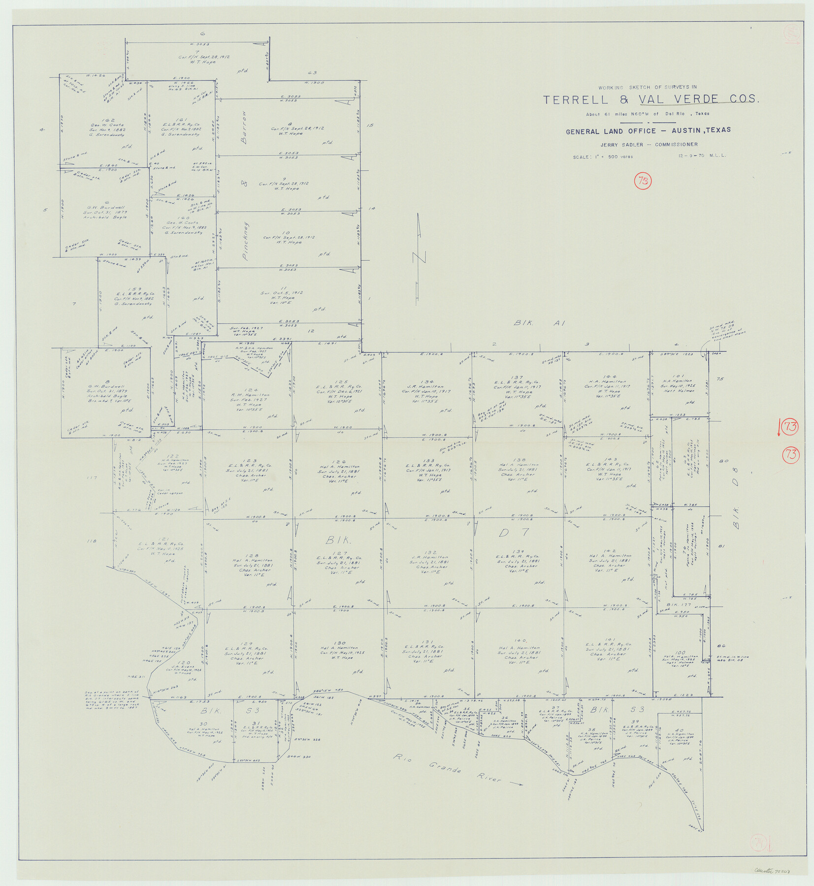
Val Verde County Working Sketch 73
-
Map/Doc
72208
-
Collection
General Map Collection
-
Object Dates
12/9/1970 (Creation Date)
-
People and Organizations
M. L. Liles (Draftsman)
-
Counties
Val Verde Terrell
-
Subjects
Surveying Working Sketch
-
Height x Width
37.6 x 34.5 inches
95.5 x 87.6 cm
-
Scale
1" = 500 varas
Part of: General Map Collection
Rains County Rolled Sketch 2

Print $41.00
- Digital $50.00
Rains County Rolled Sketch 2
1958
Size 10.4 x 15.4 inches
Map/Doc 48829
Eastland County Working Sketch 45

Print $20.00
- Digital $50.00
Eastland County Working Sketch 45
1979
Size 31.3 x 43.7 inches
Map/Doc 68826
Pecos County Working Sketch 114

Print $40.00
- Digital $50.00
Pecos County Working Sketch 114
1972
Size 75.7 x 38.0 inches
Map/Doc 71587
Le Nouveau Mexique et la Floride: Tirèes de diverses cartes, et relations

Print $20.00
- Digital $50.00
Le Nouveau Mexique et la Floride: Tirèes de diverses cartes, et relations
1656
Size 17.2 x 22.8 inches
Map/Doc 95833
Rusk County Working Sketch 32

Print $20.00
- Digital $50.00
Rusk County Working Sketch 32
1919
Size 16.7 x 17.1 inches
Map/Doc 63669
Maverick County Rolled Sketch 14

Print $20.00
- Digital $50.00
Maverick County Rolled Sketch 14
1848
Size 18.4 x 22.9 inches
Map/Doc 6707
Flight Mission No. BRA-16M, Frame 55, Jefferson County

Print $20.00
- Digital $50.00
Flight Mission No. BRA-16M, Frame 55, Jefferson County
1953
Size 18.4 x 22.4 inches
Map/Doc 85672
Briscoe County Boundary File 4

Print $66.00
- Digital $50.00
Briscoe County Boundary File 4
Size 8.7 x 7.1 inches
Map/Doc 50780
Presidio County Sketch File 21

Print $4.00
- Digital $50.00
Presidio County Sketch File 21
1889
Size 14.2 x 8.7 inches
Map/Doc 34454
Kleberg County Aerial Photograph Index Sheet 2

Print $20.00
- Digital $50.00
Kleberg County Aerial Photograph Index Sheet 2
1956
Size 19.4 x 23.4 inches
Map/Doc 83719
Crockett County Working Sketch 49

Print $20.00
- Digital $50.00
Crockett County Working Sketch 49
1938
Size 46.7 x 43.9 inches
Map/Doc 68382
Map of Scurry County

Print $20.00
- Digital $50.00
Map of Scurry County
1899
Size 39.8 x 34.7 inches
Map/Doc 63029
You may also like
[Pencil sketch in vicinity of H. G. Sims, David F. Weff, B. Allen surveys]
![91853, [Pencil sketch in vicinity of H. G. Sims, David F. Weff, B. Allen surveys], Twichell Survey Records](https://historictexasmaps.com/wmedia_w700/maps/91853-1.tif.jpg)
Print $20.00
- Digital $50.00
[Pencil sketch in vicinity of H. G. Sims, David F. Weff, B. Allen surveys]
1924
Size 18.9 x 18.2 inches
Map/Doc 91853
Cameron County Boundary File 5

Print $8.00
- Digital $50.00
Cameron County Boundary File 5
Size 8.8 x 15.3 inches
Map/Doc 51113
Dimmit County Rolled Sketch 22

Print $20.00
- Digital $50.00
Dimmit County Rolled Sketch 22
2012
Size 31.5 x 24.0 inches
Map/Doc 93629
Map of Jasper County

Print $20.00
- Digital $50.00
Map of Jasper County
1839
Size 40.2 x 28.8 inches
Map/Doc 78407
Webb County Sketch File 15-1

Print $20.00
- Digital $50.00
Webb County Sketch File 15-1
1935
Size 35.0 x 25.2 inches
Map/Doc 12634

Crockett County Sketch File 35d

Print $10.00
- Digital $50.00
Crockett County Sketch File 35d
Size 14.2 x 8.9 inches
Map/Doc 19750
Duval County Sketch File 19a

Print $40.00
- Digital $50.00
Duval County Sketch File 19a
1880
Size 12.7 x 14.2 inches
Map/Doc 21318
[Mrs. May Vinson Survey]
![91919, [Mrs. May Vinson Survey], Twichell Survey Records](https://historictexasmaps.com/wmedia_w700/maps/91919-1.tif.jpg)
Print $20.00
- Digital $50.00
[Mrs. May Vinson Survey]
Size 32.8 x 14.9 inches
Map/Doc 91919
La Salle County

Print $20.00
- Digital $50.00
La Salle County
1886
Size 25.4 x 21.3 inches
Map/Doc 3795
Tyler County Working Sketch 23

Print $20.00
- Digital $50.00
Tyler County Working Sketch 23
1988
Size 28.2 x 22.8 inches
Map/Doc 69493
Reconnoissance of Sabine Pass

Print $20.00
Reconnoissance of Sabine Pass
1853
Size 12.4 x 10.3 inches
Map/Doc 76281