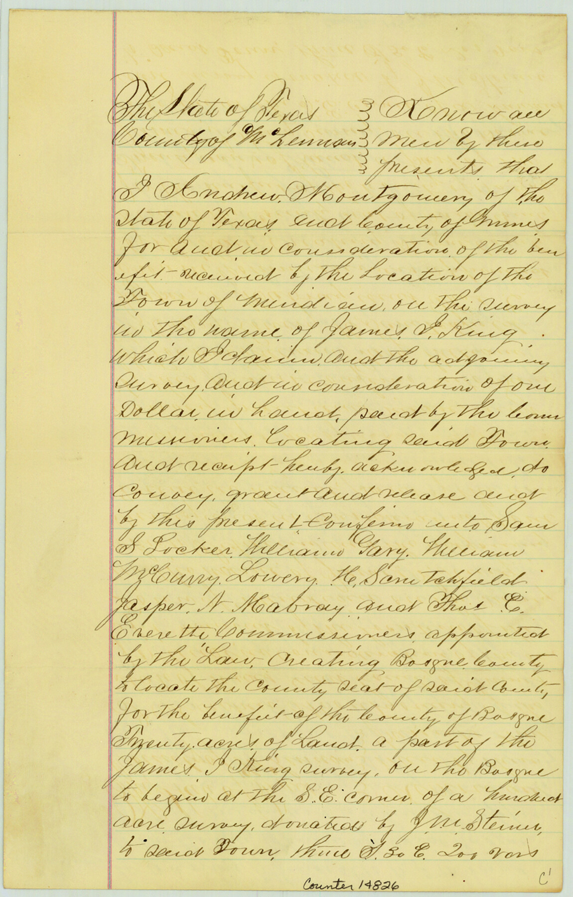
Bosque County Sketch File 30b
[Copy of deed of 20 acres from Andrew Montgomery to County Commissioners of Bosque County for location of the county seat]
-
Map/Doc
14826
-
Collection
General Map Collection
-
Object Dates
1854/7/15 (Creation Date)
1883/7/8 (File Date)
-
People and Organizations
Andrew Montgomery (Landowner)
-
Counties
Bosque
-
Subjects
Surveying Sketch File
-
Height x Width
12.7 x 8.1 inches
32.3 x 20.6 cm
-
Medium
paper, manuscript
-
Features
Bosque River
Part of: General Map Collection
Controlled Mosaic by Jack Amman Photogrammetric Engineers, Inc - Sheet 3

Print $20.00
- Digital $50.00
Controlled Mosaic by Jack Amman Photogrammetric Engineers, Inc - Sheet 3
1954
Size 20.0 x 24.0 inches
Map/Doc 83447
San Patricio County Rolled Sketch 7A

Print $20.00
- Digital $50.00
San Patricio County Rolled Sketch 7A
1870
Size 46.8 x 27.3 inches
Map/Doc 9884
Eastland County Rolled Sketch 18

Print $20.00
- Digital $50.00
Eastland County Rolled Sketch 18
Size 27.3 x 25.9 inches
Map/Doc 5776
Upton County Rolled Sketch 15

Print $20.00
- Digital $50.00
Upton County Rolled Sketch 15
1927
Size 25.0 x 19.2 inches
Map/Doc 8070
Stephens County Working Sketch 23

Print $20.00
- Digital $50.00
Stephens County Working Sketch 23
1975
Size 31.0 x 38.8 inches
Map/Doc 63966
Bandera County Sketch File 5

Print $4.00
- Digital $50.00
Bandera County Sketch File 5
Size 8.6 x 6.8 inches
Map/Doc 14003
Schleicher County Working Sketch 2

Print $20.00
- Digital $50.00
Schleicher County Working Sketch 2
1903
Size 14.7 x 19.4 inches
Map/Doc 63804
Polk County Working Sketch 43

Print $20.00
- Digital $50.00
Polk County Working Sketch 43
1997
Size 23.2 x 30.5 inches
Map/Doc 71660
Map of the West Part of Tom Green County

Print $20.00
- Digital $50.00
Map of the West Part of Tom Green County
1894
Size 46.9 x 34.7 inches
Map/Doc 63072
Howard County Working Sketch 3

Print $20.00
- Digital $50.00
Howard County Working Sketch 3
1904
Size 26.8 x 20.1 inches
Map/Doc 66269
Lampasas County Sketch File 18

Print $4.00
- Digital $50.00
Lampasas County Sketch File 18
Size 8.1 x 4.8 inches
Map/Doc 29430
Jim Wells Co.

Print $20.00
- Digital $50.00
Jim Wells Co.
1913
Size 43.7 x 22.1 inches
Map/Doc 16861
You may also like
Liberty County Sketch File 14

Print $4.00
- Digital $50.00
Liberty County Sketch File 14
1858
Size 12.9 x 8.1 inches
Map/Doc 29915
Hutchinson County Sketch File 35

Print $6.00
- Digital $50.00
Hutchinson County Sketch File 35
1935
Size 11.2 x 8.9 inches
Map/Doc 27267
Map of surveys 191 & 192 T. C. R.R. Co. in Travis County, Texas

Print $20.00
- Digital $50.00
Map of surveys 191 & 192 T. C. R.R. Co. in Travis County, Texas
1915
Size 20.6 x 13.6 inches
Map/Doc 75554
Hidalgo County Rolled Sketch 13

Print $20.00
- Digital $50.00
Hidalgo County Rolled Sketch 13
1960
Size 19.0 x 31.4 inches
Map/Doc 6212
Orange County Working Sketch 51

Print $20.00
- Digital $50.00
Orange County Working Sketch 51
1992
Size 29.6 x 22.0 inches
Map/Doc 71383
Flight Mission No. BRA-7M, Frame 139, Jefferson County

Print $20.00
- Digital $50.00
Flight Mission No. BRA-7M, Frame 139, Jefferson County
1953
Size 18.7 x 22.4 inches
Map/Doc 85533
Hudspeth County Sketch File 12

Print $10.00
- Digital $50.00
Hudspeth County Sketch File 12
1901
Size 14.2 x 8.7 inches
Map/Doc 26924
Anderson County Sketch File 16a

Print $4.00
- Digital $50.00
Anderson County Sketch File 16a
1853
Size 12.3 x 8.3 inches
Map/Doc 12786
Copy of Surveyor's Field Book, Morris Browning - In Blocks 7, 5 & 4, I&GNRRCo., Hutchinson and Carson Counties, Texas

Print $2.00
- Digital $50.00
Copy of Surveyor's Field Book, Morris Browning - In Blocks 7, 5 & 4, I&GNRRCo., Hutchinson and Carson Counties, Texas
1888
Size 6.9 x 8.9 inches
Map/Doc 62285
General Highway Map, Jasper County, Texas

Print $20.00
General Highway Map, Jasper County, Texas
1961
Size 18.2 x 24.8 inches
Map/Doc 79534
Flight Mission No. CRC-5R, Frame 43, Chambers County

Print $20.00
- Digital $50.00
Flight Mission No. CRC-5R, Frame 43, Chambers County
1956
Size 18.6 x 22.3 inches
Map/Doc 84962
Flight Mission No. DCL-7C, Frame 36, Kenedy County

Print $20.00
- Digital $50.00
Flight Mission No. DCL-7C, Frame 36, Kenedy County
1943
Size 18.5 x 22.4 inches
Map/Doc 86024