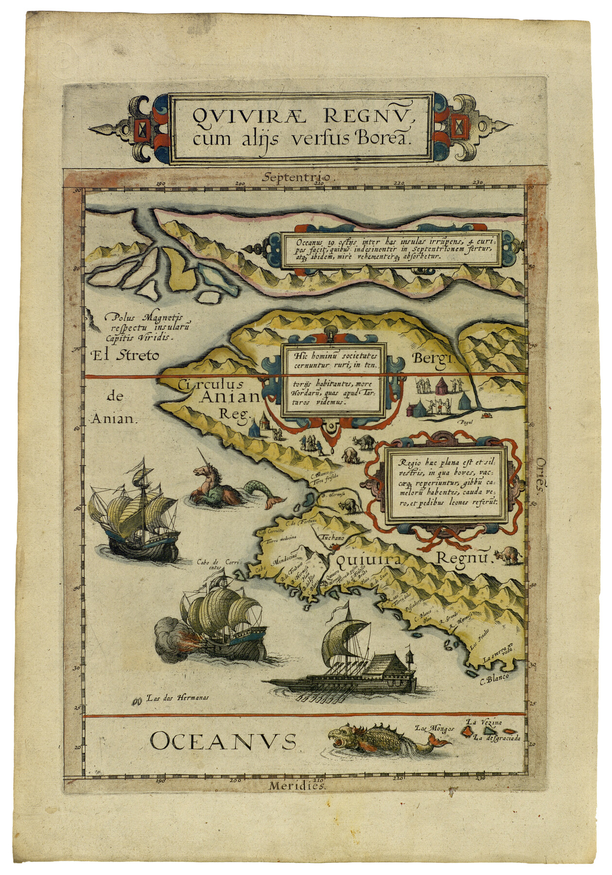
Qvivirae Regnv, cum alijs verfus Borea
-
Map/Doc
93833
-
Collection
Holcomb Digital Map Collection
-
Object Dates
1593 (Creation Date)
-
People and Organizations
[Cornelis De Jode] (Author)
-
Subjects
Atlas North America
-
Height x Width
16.7 x 11.7 inches
42.4 x 29.7 cm
-
Comments
Courtesy of Frank and Carol Holcomb.
-
URLs
https://medium.com/save-texas-history/terrors-on-the-terra-incognita-ef4d45f57725#.thjpn7q67
Part of: Holcomb Digital Map Collection
Map of North America

Print $20.00
- Digital $50.00
Map of North America
1720
Size 25.0 x 39.6 inches
Map/Doc 93823
Map of the World on Mercator's Projection, flags of all nations and cities of the United States

Print $40.00
- Digital $50.00
Map of the World on Mercator's Projection, flags of all nations and cities of the United States
1874
Size 40.4 x 55.6 inches
Map/Doc 93914
Nova Totivs Americae Descriptio

Print $20.00
- Digital $50.00
Nova Totivs Americae Descriptio
1666
Size 21.2 x 24.3 inches
Map/Doc 93818
Mexico and Internal Provinces

Print $20.00
- Digital $50.00
Mexico and Internal Provinces
1829
Size 13.6 x 15.3 inches
Map/Doc 96971
A New Map of Texas with the Contiguous American & Mexican States

Print $20.00
- Digital $50.00
A New Map of Texas with the Contiguous American & Mexican States
1835
Size 12.9 x 15.8 inches
Map/Doc 93853
Map of Texas with parts of the Adjoining States

Print $20.00
- Digital $50.00
Map of Texas with parts of the Adjoining States
1830
Size 29.6 x 24.1 inches
Map/Doc 94440
Map of Texas shewing the grants in possession of the Colorado & Red River Land Compy

Print $20.00
- Digital $50.00
Map of Texas shewing the grants in possession of the Colorado & Red River Land Compy
1835
Size 20.3 x 26.9 inches
Map/Doc 93850
Colton's New Map of the State of Texas, the Indian Territory and adjoining portions of New Mexico, Louisiana and Arkansas

Print $20.00
- Digital $50.00
Colton's New Map of the State of Texas, the Indian Territory and adjoining portions of New Mexico, Louisiana and Arkansas
1882
Size 32.8 x 37.3 inches
Map/Doc 93909

Perry and Spaulding's American Republic and Railroad Map of the United States and of the Dominion of Canada

Print $40.00
- Digital $50.00
Perry and Spaulding's American Republic and Railroad Map of the United States and of the Dominion of Canada
1874
Size 40.5 x 55.7 inches
Map/Doc 93913
La Riviere de Missisipi, et ses environs, dans l'Amerique Septentrionale

Print $20.00
- Digital $50.00
La Riviere de Missisipi, et ses environs, dans l'Amerique Septentrionale
1715
Size 22.0 x 27.8 inches
Map/Doc 96518
A New & Correct Map of the Trading Part of the West Indies, including the Seat of War between Gr. Britain and France Likewise the British Empire in America, with the French and Spanish Settlements adjacent thereto

Print $20.00
- Digital $50.00
A New & Correct Map of the Trading Part of the West Indies, including the Seat of War between Gr. Britain and France Likewise the British Empire in America, with the French and Spanish Settlements adjacent thereto
1759
Size 27.4 x 41.4 inches
Map/Doc 93826
You may also like
Zapata County Working Sketch 11

Print $20.00
- Digital $50.00
Zapata County Working Sketch 11
1958
Size 38.1 x 28.7 inches
Map/Doc 62062
Hutchinson County Sketch File 18

Print $28.00
- Digital $50.00
Hutchinson County Sketch File 18
1909
Size 6.7 x 8.3 inches
Map/Doc 27220
University of Texas System University Lands

Print $20.00
- Digital $50.00
University of Texas System University Lands
1938
Size 17.9 x 23.5 inches
Map/Doc 93249
Cooke County Working Sketch 23

Print $20.00
- Digital $50.00
Cooke County Working Sketch 23
1969
Size 32.1 x 33.4 inches
Map/Doc 68260
Menard County Sketch File 1

Print $4.00
- Digital $50.00
Menard County Sketch File 1
1859
Size 9.8 x 8.5 inches
Map/Doc 31484
Crockett County Rolled Sketch 88M

Print $20.00
- Digital $50.00
Crockett County Rolled Sketch 88M
1964
Size 25.2 x 34.2 inches
Map/Doc 5629
Flight Mission No. BRE-1P, Frame 153, Nueces County

Print $20.00
- Digital $50.00
Flight Mission No. BRE-1P, Frame 153, Nueces County
1956
Size 18.5 x 22.5 inches
Map/Doc 86714
Harris County Working Sketch 69

Print $20.00
- Digital $50.00
Harris County Working Sketch 69
1956
Size 32.7 x 28.2 inches
Map/Doc 65961
Map of Cooke County

Print $20.00
- Digital $50.00
Map of Cooke County
1868
Size 21.7 x 17.9 inches
Map/Doc 3439
Anderson County Sketch File 30

Print $4.00
- Digital $50.00
Anderson County Sketch File 30
1989
Size 11.3 x 8.6 inches
Map/Doc 12816

Presidio County Rolled Sketch 46

Print $20.00
- Digital $50.00
Presidio County Rolled Sketch 46
1908
Size 19.0 x 15.5 inches
Map/Doc 7342