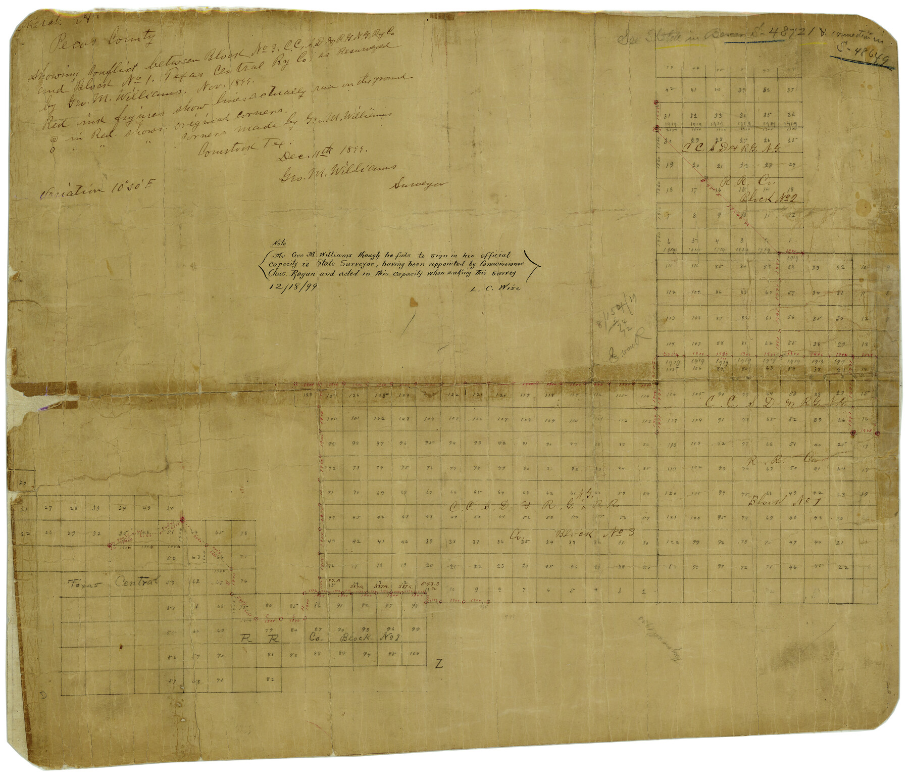
Pecos County Rolled Sketch 26
[Sketch showing conflict between Block 3, C. C. S. D. & R. G. N. G. Ry. Co. and Block 1, Texas Central Ry. Co.]
-
Map/Doc
7211
-
Collection
General Map Collection
-
Object Dates
12/11/1899 (Creation Date)
-
People and Organizations
Geo. M. Williams (Surveyor/Engineer)
-
Counties
Pecos Terrell
-
Subjects
Surveying Rolled Sketch
-
Height x Width
19.9 x 23.6 inches
50.6 x 59.9 cm
-
Medium
paper, manuscript
Related maps
Terrell County Sketch File 6

Print $28.00
- Digital $50.00
Terrell County Sketch File 6
1899
Size 13.0 x 8.5 inches
Map/Doc 37888
Part of: General Map Collection
Map of North America to illustrate Olney's school geography

Print $20.00
- Digital $50.00
Map of North America to illustrate Olney's school geography
1844
Size 12.1 x 9.3 inches
Map/Doc 93536
Liberty County Sketch File 68

Print $24.00
- Digital $50.00
Liberty County Sketch File 68
Size 11.0 x 8.5 inches
Map/Doc 94021
Flight Mission No. DQN-3K, Frame 69, Calhoun County

Print $20.00
- Digital $50.00
Flight Mission No. DQN-3K, Frame 69, Calhoun County
1953
Size 18.5 x 22.3 inches
Map/Doc 84360
Karnes County Sketch File 10

Print $10.00
- Digital $50.00
Karnes County Sketch File 10
1885
Size 12.8 x 8.5 inches
Map/Doc 28597
[Gulf Coast of Texas]
![72704, [Gulf Coast of Texas], General Map Collection](https://historictexasmaps.com/wmedia_w700/maps/72704.tif.jpg)
Print $20.00
- Digital $50.00
[Gulf Coast of Texas]
1881
Size 28.7 x 18.2 inches
Map/Doc 72704
Brewster County Sketch File NS-4g

Print $4.00
- Digital $50.00
Brewster County Sketch File NS-4g
1930
Size 10.5 x 7.2 inches
Map/Doc 15981
Menard County Rolled Sketch 6

Print $20.00
- Digital $50.00
Menard County Rolled Sketch 6
Size 17.3 x 21.2 inches
Map/Doc 6755
Borden County Rolled Sketch 9

Print $40.00
- Digital $50.00
Borden County Rolled Sketch 9
1951
Size 114.7 x 29.6 inches
Map/Doc 8448
Culberson County Working Sketch 56

Print $20.00
- Digital $50.00
Culberson County Working Sketch 56
1974
Size 38.7 x 32.1 inches
Map/Doc 68510
Sabine River, East Extension Merrill Lake Sheet

Print $4.00
- Digital $50.00
Sabine River, East Extension Merrill Lake Sheet
1933
Size 24.5 x 15.1 inches
Map/Doc 65141
Eastland County Working Sketch 49

Print $20.00
- Digital $50.00
Eastland County Working Sketch 49
1981
Size 29.0 x 24.6 inches
Map/Doc 68830
Gregg County Working Sketch Graphic Index

Print $20.00
- Digital $50.00
Gregg County Working Sketch Graphic Index
1933
Size 32.4 x 29.5 inches
Map/Doc 76559
You may also like
Webb County Rolled Sketch 73

Print $20.00
- Digital $50.00
Webb County Rolled Sketch 73
1982
Size 33.2 x 17.2 inches
Map/Doc 8221
Flight Mission No. DQO-1K, Frame 151, Galveston County

Print $20.00
- Digital $50.00
Flight Mission No. DQO-1K, Frame 151, Galveston County
1952
Size 18.8 x 22.5 inches
Map/Doc 85004
Live Oak County Sketch File 34

Print $28.00
- Digital $50.00
Live Oak County Sketch File 34
1963
Size 31.0 x 23.9 inches
Map/Doc 12011
Louisiana and Texas Intracoastal Waterway - Dredging Tributary Channel, Port Aransas to Aransas Pass, Texas

Print $20.00
- Digital $50.00
Louisiana and Texas Intracoastal Waterway - Dredging Tributary Channel, Port Aransas to Aransas Pass, Texas
1940
Size 31.1 x 42.3 inches
Map/Doc 61820
Nueces County Rolled Sketch 72

Print $20.00
- Digital $50.00
Nueces County Rolled Sketch 72
1980
Size 18.1 x 25.8 inches
Map/Doc 6930
Runnels County Sketch File 24

Print $20.00
Runnels County Sketch File 24
1930
Size 25.2 x 21.3 inches
Map/Doc 12258
The Republic County of Galveston. December 29, 1845

Print $20.00
The Republic County of Galveston. December 29, 1845
2020
Size 14.7 x 21.9 inches
Map/Doc 96146
San Antonio & Surrounding Area

San Antonio & Surrounding Area
1997
Size 36.4 x 46.3 inches
Map/Doc 96867
General Highway Map. Detail of Cities and Towns in Smith County, Texas. City Map, Tyler and vicinity, Smith County, Texas

Print $20.00
General Highway Map. Detail of Cities and Towns in Smith County, Texas. City Map, Tyler and vicinity, Smith County, Texas
1961
Size 18.2 x 24.9 inches
Map/Doc 79657
Kinney County Sketch File A1

Print $38.00
- Digital $50.00
Kinney County Sketch File A1
1905
Size 35.4 x 27.6 inches
Map/Doc 11952
Kerr County Sketch File 13

Print $11.00
- Digital $50.00
Kerr County Sketch File 13
1927
Size 16.9 x 8.1 inches
Map/Doc 28883
[Various County School Land Leagues]
![89849, [Various County School Land Leagues], Twichell Survey Records](https://historictexasmaps.com/wmedia_w700/maps/89849-1.tif.jpg)
Print $40.00
- Digital $50.00
[Various County School Land Leagues]
Size 55.7 x 41.4 inches
Map/Doc 89849