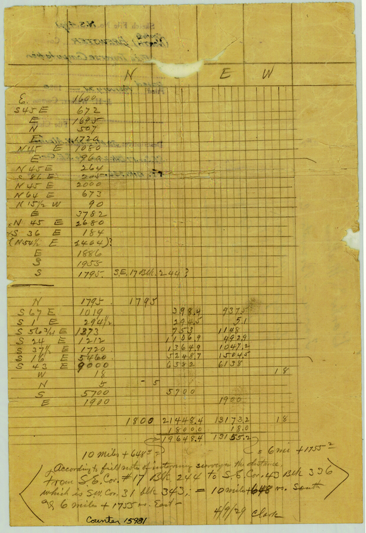
Brewster County Sketch File NS-4g
[Office traverse computation - SE cor. no. 17, Block 244 to SE cor. no. 43, Block 336]
-
Map/Doc
15981
-
Collection
General Map Collection
-
Object Dates
1930/2/21 (Creation Date)
1930/2/21 (File Date)
-
Counties
Brewster
-
Subjects
Surveying Sketch File
-
Height x Width
10.5 x 7.2 inches
26.7 x 18.3 cm
-
Medium
paper, manuscript
Part of: General Map Collection
Matagorda County NRC Article 33.136 Location Key Sheet

Print $20.00
- Digital $50.00
Matagorda County NRC Article 33.136 Location Key Sheet
1973
Size 27.0 x 23.0 inches
Map/Doc 88832
[Sketch for Mineral Application 24072, San Jacinto River]
![65604, [Sketch for Mineral Application 24072, San Jacinto River], General Map Collection](https://historictexasmaps.com/wmedia_w700/maps/65604.tif.jpg)
Print $20.00
- Digital $50.00
[Sketch for Mineral Application 24072, San Jacinto River]
1929
Size 23.3 x 17.5 inches
Map/Doc 65604
Map of Armstrong County

Print $20.00
- Digital $50.00
Map of Armstrong County
1881
Size 25.8 x 19.9 inches
Map/Doc 3243
Gregg County Rolled Sketch 22

Print $20.00
- Digital $50.00
Gregg County Rolled Sketch 22
1934
Size 30.0 x 41.6 inches
Map/Doc 9073
Eastland County Working Sketch 62

Print $20.00
- Digital $50.00
Eastland County Working Sketch 62
1989
Size 20.7 x 28.0 inches
Map/Doc 68843
[Surveys near the Neches River]
![8, [Surveys near the Neches River], General Map Collection](https://historictexasmaps.com/wmedia_w700/maps/8.tif.jpg)
Print $3.00
- Digital $50.00
[Surveys near the Neches River]
Size 17.2 x 10.3 inches
Map/Doc 8
Falls County Sketch File 28

Print $2.00
- Digital $50.00
Falls County Sketch File 28
Size 7.7 x 10.3 inches
Map/Doc 22438
Lampasas County Sketch File 7

Print $4.00
- Digital $50.00
Lampasas County Sketch File 7
1871
Size 8.4 x 8.2 inches
Map/Doc 29402
Flight Mission No. DQN-2K, Frame 89, Calhoun County

Print $20.00
- Digital $50.00
Flight Mission No. DQN-2K, Frame 89, Calhoun County
1953
Size 16.2 x 15.7 inches
Map/Doc 84279
Galveston Bay Entrance - Galveston and Texas City Harbors

Print $40.00
- Digital $50.00
Galveston Bay Entrance - Galveston and Texas City Harbors
1975
Size 37.4 x 53.5 inches
Map/Doc 69864

Baylor County Working Sketch 2

Print $20.00
- Digital $50.00
Baylor County Working Sketch 2
1919
Size 22.4 x 24.1 inches
Map/Doc 67287
You may also like
[Atlas A, Table of Contents, part 1]
![78351, [Atlas A, Table of Contents, part 1], General Map Collection](https://historictexasmaps.com/wmedia_w700/maps/78351.tif.jpg)
Print $20.00
- Digital $50.00
[Atlas A, Table of Contents, part 1]
Size 14.5 x 15.0 inches
Map/Doc 78351
[Mrs. May Vinson Survey]
![91959, [Mrs. May Vinson Survey], Twichell Survey Records](https://historictexasmaps.com/wmedia_w700/maps/91959-1.tif.jpg)
Print $40.00
- Digital $50.00
[Mrs. May Vinson Survey]
Size 48.4 x 21.9 inches
Map/Doc 91959
Tom Green County Rolled Sketch 48

Print $20.00
- Digital $50.00
Tom Green County Rolled Sketch 48
1884
Size 14.3 x 22.7 inches
Map/Doc 8009
Red River County Working Sketch 73

Print $20.00
- Digital $50.00
Red River County Working Sketch 73
1979
Size 17.0 x 19.2 inches
Map/Doc 72056
Palo Pinto County Sketch File 8

Print $40.00
- Digital $50.00
Palo Pinto County Sketch File 8
Size 15.3 x 15.6 inches
Map/Doc 33400
Bird's Eye View of Brenham, Washington County, Texas

Print $20.00
Bird's Eye View of Brenham, Washington County, Texas
1873
Size 20.0 x 25.7 inches
Map/Doc 89075
Lovington Lea County, N. M. Lots 11, 14-Sec. 4-16-36

Print $40.00
- Digital $50.00
Lovington Lea County, N. M. Lots 11, 14-Sec. 4-16-36
Size 28.8 x 49.9 inches
Map/Doc 89694
[H. & G. N. Block 1]
![90944, [H. & G. N. Block 1], Twichell Survey Records](https://historictexasmaps.com/wmedia_w700/maps/90944-1.tif.jpg)
Print $20.00
- Digital $50.00
[H. & G. N. Block 1]
1873
Size 17.7 x 14.3 inches
Map/Doc 90944
Andrews County Sketch File 15

Print $24.00
- Digital $50.00
Andrews County Sketch File 15
Size 11.2 x 8.9 inches
Map/Doc 12887
Coast Chart No. 212 - From Latitude 26° 33' to the Rio Grande Texas

Print $20.00
- Digital $50.00
Coast Chart No. 212 - From Latitude 26° 33' to the Rio Grande Texas
1886
Size 18.4 x 27.8 inches
Map/Doc 72826
Gillespie County Sketch File 3a

Print $4.00
- Digital $50.00
Gillespie County Sketch File 3a
1860
Size 7.6 x 8.3 inches
Map/Doc 24131
Map of East Texas Oil Field

Print $20.00
- Digital $50.00
Map of East Texas Oil Field
1933
Size 16.5 x 17.8 inches
Map/Doc 93949