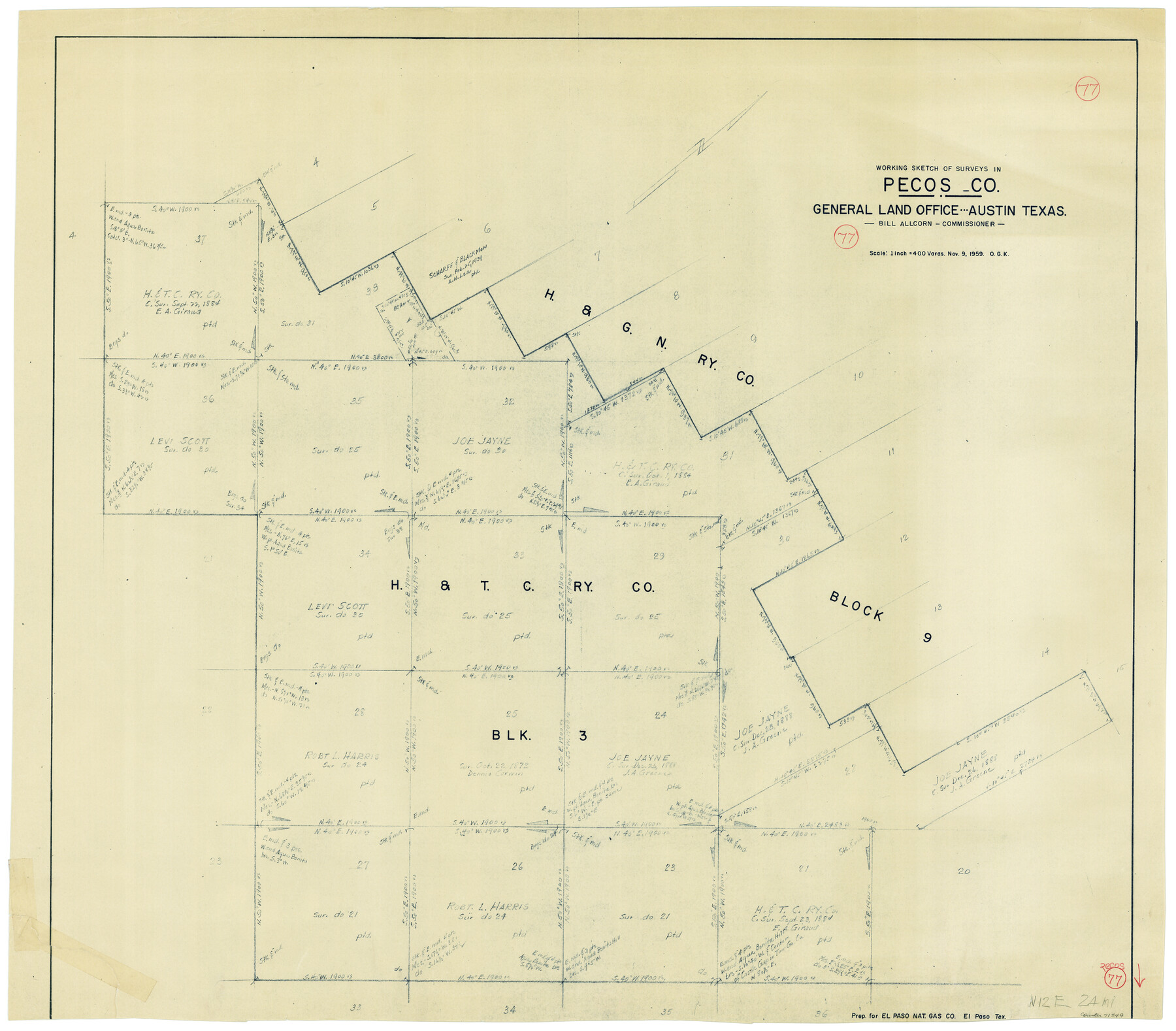
Pecos County Working Sketch 77
-
Map/Doc
71549
-
Collection
General Map Collection
-
Object Dates
11/9/1959 (Creation Date)
-
People and Organizations
Otto G. Kurio (Draftsman)
-
Counties
Pecos
-
Subjects
Surveying Working Sketch
-
Height x Width
32.0 x 36.4 inches
81.3 x 92.5 cm
-
Scale
1" = 400 varas
Part of: General Map Collection
Flight Mission No. CUG-1P, Frame 41, Kleberg County

Print $20.00
- Digital $50.00
Flight Mission No. CUG-1P, Frame 41, Kleberg County
1956
Size 18.7 x 22.3 inches
Map/Doc 86119
Houston County Sketch File 39

Print $6.00
- Digital $50.00
Houston County Sketch File 39
1845
Size 17.0 x 10.9 inches
Map/Doc 26824

Andrews County Rolled Sketch 24

Print $20.00
- Digital $50.00
Andrews County Rolled Sketch 24
1946
Size 43.0 x 35.8 inches
Map/Doc 8397
Right-of-Way & Track Map, Houston and Brazos Valley Ry. Co. operated by the Houston and Brazos Valley Ry. Co.

Print $40.00
- Digital $50.00
Right-of-Way & Track Map, Houston and Brazos Valley Ry. Co. operated by the Houston and Brazos Valley Ry. Co.
1918
Size 24.7 x 56.7 inches
Map/Doc 64604
Flight Mission No. BRA-16M, Frame 161, Jefferson County

Print $20.00
- Digital $50.00
Flight Mission No. BRA-16M, Frame 161, Jefferson County
1953
Size 18.5 x 22.3 inches
Map/Doc 85759
Frio County Boundary File 31b

Print $72.00
- Digital $50.00
Frio County Boundary File 31b
Size 9.4 x 4.5 inches
Map/Doc 53617
Flight Mission No. CRE-2R, Frame 157, Jackson County

Print $20.00
- Digital $50.00
Flight Mission No. CRE-2R, Frame 157, Jackson County
1956
Size 18.4 x 22.3 inches
Map/Doc 85368
Flight Mission No. DQO-8K, Frame 48, Galveston County

Print $20.00
- Digital $50.00
Flight Mission No. DQO-8K, Frame 48, Galveston County
1952
Size 18.7 x 22.2 inches
Map/Doc 85155
Flight Mission No. DIX-3P, Frame 170, Aransas County

Print $20.00
- Digital $50.00
Flight Mission No. DIX-3P, Frame 170, Aransas County
1956
Size 17.8 x 18.2 inches
Map/Doc 83776
Flight Mission No. DIX-10P, Frame 75, Aransas County

Print $20.00
- Digital $50.00
Flight Mission No. DIX-10P, Frame 75, Aransas County
1956
Size 18.6 x 22.3 inches
Map/Doc 83936
Webb County Rolled Sketch EF4

Print $20.00
- Digital $50.00
Webb County Rolled Sketch EF4
1929
Size 33.2 x 24.4 inches
Map/Doc 8226
You may also like
Comanche County Sketch File 6

Print $4.00
- Digital $50.00
Comanche County Sketch File 6
1854
Size 12.7 x 8.4 inches
Map/Doc 19061
Flight Mission No. DIX-10P, Frame 76, Aransas County

Print $20.00
- Digital $50.00
Flight Mission No. DIX-10P, Frame 76, Aransas County
1956
Size 18.8 x 22.4 inches
Map/Doc 83937
Gonzales County Boundary File 2a

Print $8.00
- Digital $50.00
Gonzales County Boundary File 2a
Size 14.4 x 8.9 inches
Map/Doc 53832
Map of Block 1, H. & G. N. Railroad Company

Print $20.00
- Digital $50.00
Map of Block 1, H. & G. N. Railroad Company
1909
Size 24.0 x 30.1 inches
Map/Doc 91017
Terry County Rolled Sketch 2

Print $20.00
- Digital $50.00
Terry County Rolled Sketch 2
1908
Size 25.5 x 36.8 inches
Map/Doc 7980
Flight Mission No. CRC-5R, Frame 16, Chambers County

Print $20.00
- Digital $50.00
Flight Mission No. CRC-5R, Frame 16, Chambers County
1956
Size 18.6 x 22.4 inches
Map/Doc 84938
Translations of Titles - Austin's Second Contract, Vol. 3

Translations of Titles - Austin's Second Contract, Vol. 3
1841
Map/Doc 94548
[John S. Stephens Blk. S-2, J. A. Oden Blk. 1, Lgs. 174-176]
![90188, [John S. Stephens Blk. S-2, J. A. Oden Blk. 1, Lgs. 174-176], Twichell Survey Records](https://historictexasmaps.com/wmedia_w700/maps/90188-1.tif.jpg)
Print $20.00
- Digital $50.00
[John S. Stephens Blk. S-2, J. A. Oden Blk. 1, Lgs. 174-176]
1913
Size 23.5 x 27.0 inches
Map/Doc 90188
Uvalde County Working Sketch 6

Print $20.00
- Digital $50.00
Uvalde County Working Sketch 6
1940
Size 37.8 x 38.9 inches
Map/Doc 72076
Flight Mission No. CUG-1P, Frame 163, Kleberg County

Print $20.00
- Digital $50.00
Flight Mission No. CUG-1P, Frame 163, Kleberg County
1956
Size 18.6 x 22.2 inches
Map/Doc 86170
Jim Hogg County

Print $20.00
- Digital $50.00
Jim Hogg County
1962
Size 40.3 x 28.5 inches
Map/Doc 77330
National Map Company's Ohio showing Counties, Townships, Cities, Villages, Post Offices, Steam and Electric Railways, With Stations and Distances Between Stations

Print $20.00
- Digital $50.00
National Map Company's Ohio showing Counties, Townships, Cities, Villages, Post Offices, Steam and Electric Railways, With Stations and Distances Between Stations
1920
Size 38.7 x 32.3 inches
Map/Doc 97109