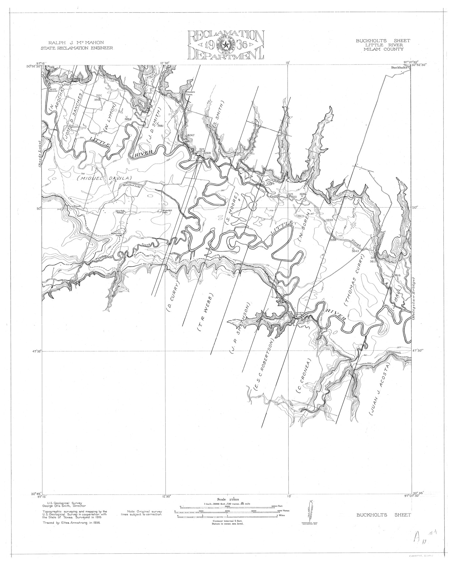
Little River, Buckholts Sheet
-
Map/Doc
65065
-
Collection
General Map Collection
-
Object Dates
1936 (Creation Date)
-
People and Organizations
Texas State Reclamation Department (Publisher)
Eltea Armstrong (Draftsman)
-
Counties
Milam
-
Subjects
River Surveys Topographic
-
Height x Width
30.0 x 24.2 inches
76.2 x 61.5 cm
-
Comments
Little River is formed by the union of Leon River and Lampasas River. Flows southeasterly into the Brazos River.
Buckholts Sheet is located east of the Reeds Lake Sheet and west of the Holtzclaw Bridge Sheet.
Part of: General Map Collection
Cass County Rolled Sketch OPD

Print $20.00
- Digital $50.00
Cass County Rolled Sketch OPD
1936
Size 29.4 x 25.1 inches
Map/Doc 5483
Tyler County Working Sketch 26

Print $20.00
- Digital $50.00
Tyler County Working Sketch 26
Size 27.7 x 46.3 inches
Map/Doc 69496
Hall County Rolled Sketch 8

Print $20.00
- Digital $50.00
Hall County Rolled Sketch 8
1942
Size 24.7 x 41.6 inches
Map/Doc 6052
Rusk County Working Sketch 6

Print $20.00
- Digital $50.00
Rusk County Working Sketch 6
1982
Size 32.8 x 32.9 inches
Map/Doc 63641
Austin County Working Sketch 7

Print $40.00
- Digital $50.00
Austin County Working Sketch 7
1992
Size 30.9 x 48.8 inches
Map/Doc 67248
Midland County Rolled Sketch 2

Print $20.00
- Digital $50.00
Midland County Rolled Sketch 2
1949
Size 39.3 x 36.5 inches
Map/Doc 9513
Map exhibiting the lines of march passed over by the troops of the United States during the year ending June 30th, 1858 prepared by order of the Hon. J.B. Floyd, Sec. War.

Print $20.00
- Digital $50.00
Map exhibiting the lines of march passed over by the troops of the United States during the year ending June 30th, 1858 prepared by order of the Hon. J.B. Floyd, Sec. War.
1858
Size 20.0 x 20.3 inches
Map/Doc 94079
Harbor Pass and Bar at Brazos Santiago, Texas

Print $20.00
- Digital $50.00
Harbor Pass and Bar at Brazos Santiago, Texas
1871
Size 18.3 x 26.8 inches
Map/Doc 72982

[Surveys along the Cibolo, Balcones and Leon Creeks]
![69728, [Surveys along the Cibolo, Balcones and Leon Creeks], General Map Collection](https://historictexasmaps.com/wmedia_w700/maps/69728-1.tif.jpg)
Print $20.00
- Digital $50.00
[Surveys along the Cibolo, Balcones and Leon Creeks]
1841
Size 14.5 x 21.0 inches
Map/Doc 69728
Map of Hill County

Print $20.00
- Digital $50.00
Map of Hill County
1882
Size 21.6 x 25.5 inches
Map/Doc 3669

You may also like
Fort Bend County Rolled Sketch 30 1/2

Print $20.00
- Digital $50.00
Fort Bend County Rolled Sketch 30 1/2
Size 20.1 x 26.5 inches
Map/Doc 5902
Zavala County Sketch File 21

Print $4.00
- Digital $50.00
Zavala County Sketch File 21
1915
Size 11.5 x 8.8 inches
Map/Doc 41376
The Republic County of Robertson. November 28, 1839

Print $20.00
The Republic County of Robertson. November 28, 1839
2020
Size 18.9 x 21.6 inches
Map/Doc 96260
[St. L. S-W. Ry. Of Texas Map of Lufkin Branch in Cherokee County Texas]
![64021, [St. L. S-W. Ry. Of Texas Map of Lufkin Branch in Cherokee County Texas], General Map Collection](https://historictexasmaps.com/wmedia_w700/maps/64021.tif.jpg)
Print $40.00
- Digital $50.00
[St. L. S-W. Ry. Of Texas Map of Lufkin Branch in Cherokee County Texas]
1912
Size 23.4 x 124.3 inches
Map/Doc 64021
Tyler County Sketch File 3

Print $10.00
- Digital $50.00
Tyler County Sketch File 3
1855
Size 8.5 x 8.0 inches
Map/Doc 38622
Swisher County Sketch File 11

Print $58.00
- Digital $50.00
Swisher County Sketch File 11
1917
Size 9.1 x 8.3 inches
Map/Doc 37633
Flight Mission No. DQO-7K, Frame 109, Galveston County

Print $20.00
- Digital $50.00
Flight Mission No. DQO-7K, Frame 109, Galveston County
1952
Size 18.7 x 22.4 inches
Map/Doc 85124
Young County Working Sketch 1

Print $20.00
- Digital $50.00
Young County Working Sketch 1
1960
Size 31.1 x 41.9 inches
Map/Doc 62024
Boundary Between the United States & Mexico Agreed upon by the Joint Commission under the Treaty of Guadalupe Hidalgo

Print $4.00
- Digital $50.00
Boundary Between the United States & Mexico Agreed upon by the Joint Commission under the Treaty of Guadalupe Hidalgo
1853
Size 18.3 x 26.8 inches
Map/Doc 72881
Menard County Sketch File 31

Print $4.00
- Digital $50.00
Menard County Sketch File 31
1978
Size 14.2 x 8.7 inches
Map/Doc 31573
Map of Part of Espiritu Santo and San Antonio Bays and Vicinity, Texas

Print $40.00
- Digital $50.00
Map of Part of Espiritu Santo and San Antonio Bays and Vicinity, Texas
1859
Size 31.6 x 53.1 inches
Map/Doc 69983
USGS Topographic: Texas-Oklahoma Denison Quadrangle

Print $20.00
- Digital $50.00
USGS Topographic: Texas-Oklahoma Denison Quadrangle
1901
Size 21.3 x 17.4 inches
Map/Doc 75108