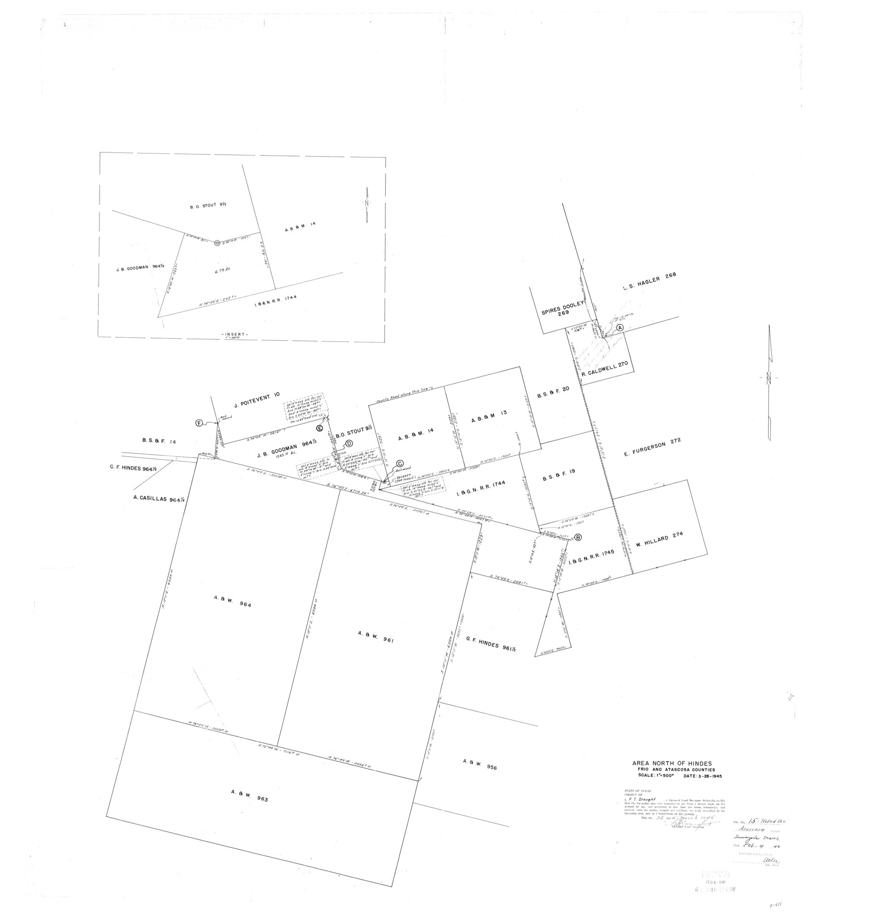
Atascosa County Rolled Sketch 15
Area north of Hindes, Frio and Atascosa Counties
-
Map/Doc
8433
-
Collection
General Map Collection
-
Object Dates
1945/3/26 (Creation Date)
1946/2/4 (File Date)
-
People and Organizations
F.T. Drought (Surveyor/Engineer)
-
Counties
Atascosa Frio
-
Subjects
Surveying Rolled Sketch
-
Height x Width
45.2 x 42.7 inches
114.8 x 108.5 cm
-
Medium
blueprint/diazo
-
Scale
1" = 500 varas
Part of: General Map Collection
Runnels County Sketch File 32

Print $4.00
Runnels County Sketch File 32
1950
Size 23.6 x 22.6 inches
Map/Doc 12263
Comanche County Sketch File 23

Print $4.00
- Digital $50.00
Comanche County Sketch File 23
Size 8.3 x 7.5 inches
Map/Doc 19111
Liberty County Sketch File 9

Print $8.00
- Digital $50.00
Liberty County Sketch File 9
1857
Size 8.0 x 8.1 inches
Map/Doc 29900
[Atlas E, Table of Contents]
![78357, [Atlas E, Table of Contents], General Map Collection](https://historictexasmaps.com/wmedia_w700/maps/78357.tif.jpg)
Print $3.00
- Digital $50.00
[Atlas E, Table of Contents]
Size 17.8 x 11.0 inches
Map/Doc 78357
Flight Mission No. BQY-15M, Frame 22, Harris County

Print $20.00
- Digital $50.00
Flight Mission No. BQY-15M, Frame 22, Harris County
1953
Size 18.6 x 22.3 inches
Map/Doc 85320
Carson County Boundary File 6

Print $48.00
- Digital $50.00
Carson County Boundary File 6
Size 12.8 x 8.3 inches
Map/Doc 51151
Hemphill County

Print $20.00
- Digital $50.00
Hemphill County
1888
Size 23.9 x 18.3 inches
Map/Doc 3653
Trinity County Sketch File 38

Print $8.00
- Digital $50.00
Trinity County Sketch File 38
1948
Size 14.5 x 8.9 inches
Map/Doc 38593
Val Verde County Working Sketch Graphic Index, Sheet 1 (Sketches 1 to 25)

Print $20.00
- Digital $50.00
Val Verde County Working Sketch Graphic Index, Sheet 1 (Sketches 1 to 25)
1944
Size 40.4 x 36.5 inches
Map/Doc 76724

Webb County Sketch File 17

Print $20.00
- Digital $50.00
Webb County Sketch File 17
Size 13.5 x 15.4 inches
Map/Doc 12636
Culberson County Sketch File 27a

Print $28.00
- Digital $50.00
Culberson County Sketch File 27a
Size 11.2 x 8.5 inches
Map/Doc 20266
You may also like
Nueces County NRC Article 33.136 Sketch 11

Print $20.00
- Digital $50.00
Nueces County NRC Article 33.136 Sketch 11
2000
Size 25.8 x 43.0 inches
Map/Doc 84334
Navarro County Working Sketch 13

Print $20.00
- Digital $50.00
Navarro County Working Sketch 13
1980
Size 15.6 x 16.1 inches
Map/Doc 71243
Austin County Working Sketch 8

Print $20.00
- Digital $50.00
Austin County Working Sketch 8
1992
Size 28.7 x 31.6 inches
Map/Doc 67249
Van Zandt County Sketch File 9a

Print $4.00
- Digital $50.00
Van Zandt County Sketch File 9a
1858
Size 12.4 x 8.0 inches
Map/Doc 39393
The Republic County of Fayette. January 29, 1842

Print $20.00
The Republic County of Fayette. January 29, 1842
2020
Size 14.7 x 21.7 inches
Map/Doc 96134
Flight Mission No. BRA-8M, Frame 115, Jefferson County

Print $20.00
- Digital $50.00
Flight Mission No. BRA-8M, Frame 115, Jefferson County
1953
Size 18.6 x 22.2 inches
Map/Doc 85611
Hopkins County Sketch File 29

Print $4.00
- Digital $50.00
Hopkins County Sketch File 29
1873
Size 10.0 x 8.1 inches
Map/Doc 26740
Flight Mission No. CRK-8P, Frame 120, Refugio County

Print $20.00
- Digital $50.00
Flight Mission No. CRK-8P, Frame 120, Refugio County
1956
Size 18.4 x 22.1 inches
Map/Doc 86975
Ward County Sketch File 8

Print $20.00
- Digital $50.00
Ward County Sketch File 8
Size 13.3 x 22.8 inches
Map/Doc 12599
Bell County Sketch File 7

Print $40.00
- Digital $50.00
Bell County Sketch File 7
1850
Size 15.8 x 12.5 inches
Map/Doc 14375

Lynn County Working Sketch 1

Print $20.00
- Digital $50.00
Lynn County Working Sketch 1
1945
Size 17.2 x 14.0 inches
Map/Doc 70671