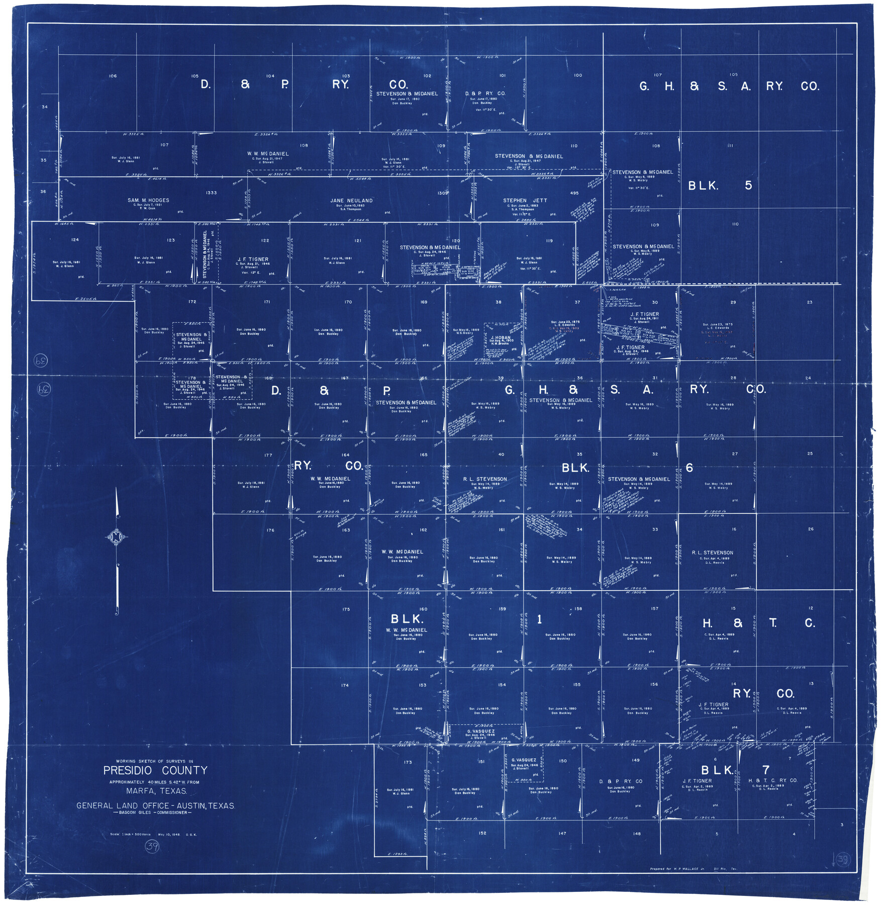
Presidio County Working Sketch 39
-
Map/Doc
71716
-
Collection
General Map Collection
-
Object Dates
5/10/1948 (Creation Date)
-
People and Organizations
Otto G. Kurio (Draftsman)
-
Counties
Presidio
-
Subjects
Surveying Working Sketch
-
Height x Width
44.6 x 43.4 inches
113.3 x 110.2 cm
-
Scale
1" = 500 varas
Part of: General Map Collection
Coryell County Boundary File 2

Print $4.00
- Digital $50.00
Coryell County Boundary File 2
Size 5.6 x 8.2 inches
Map/Doc 51905
Matagorda Light to Aransas Pass

Print $20.00
- Digital $50.00
Matagorda Light to Aransas Pass
1924
Size 35.9 x 44.6 inches
Map/Doc 73391
Gaines County Working Sketch 10

Print $40.00
- Digital $50.00
Gaines County Working Sketch 10
1953
Size 53.0 x 38.0 inches
Map/Doc 69310
Johnson County Sketch File 25

Print $50.00
- Digital $50.00
Johnson County Sketch File 25
Size 13.9 x 8.3 inches
Map/Doc 28459
Henderson County Working Sketch 43

Print $20.00
- Digital $50.00
Henderson County Working Sketch 43
1994
Size 36.7 x 39.0 inches
Map/Doc 66176
Grayson County Working Sketch 23

Print $20.00
- Digital $50.00
Grayson County Working Sketch 23
1976
Size 18.6 x 24.3 inches
Map/Doc 63262
Guadalupe County Sketch File 15a

Print $9.00
- Digital $50.00
Guadalupe County Sketch File 15a
Size 10.3 x 8.2 inches
Map/Doc 24687
Tyler County Sketch File 5

Print $20.00
- Digital $50.00
Tyler County Sketch File 5
1854
Size 13.2 x 17.4 inches
Map/Doc 12497
Donley County Boundary File 9

Print $50.00
- Digital $50.00
Donley County Boundary File 9
1903
Size 13.0 x 8.1 inches
Map/Doc 62233
Jim Wells County Sketch File 1

Print $20.00
- Digital $50.00
Jim Wells County Sketch File 1
1931
Size 22.9 x 22.1 inches
Map/Doc 11889
Navigation Maps of Gulf Intracoastal Waterway, Port Arthur to Brownsville, Texas

Print $4.00
- Digital $50.00
Navigation Maps of Gulf Intracoastal Waterway, Port Arthur to Brownsville, Texas
1951
Size 16.7 x 21.5 inches
Map/Doc 65441
Gaines County Rolled Sketch 14

Print $40.00
- Digital $50.00
Gaines County Rolled Sketch 14
Size 23.8 x 325.9 inches
Map/Doc 9030
You may also like
Red River County Sketch File 1a

Print $4.00
- Digital $50.00
Red River County Sketch File 1a
1854
Size 12.7 x 8.0 inches
Map/Doc 35093
S.P.O. Co. No. 7, State Submerged Tract No. 12, Laguna Madre, Nueces Co., Texas

Print $20.00
- Digital $50.00
S.P.O. Co. No. 7, State Submerged Tract No. 12, Laguna Madre, Nueces Co., Texas
1937
Size 27.9 x 27.4 inches
Map/Doc 3026
Hood County Sketch File 9

Print $26.00
- Digital $50.00
Hood County Sketch File 9
1859
Size 9.6 x 4.5 inches
Map/Doc 26586
Flight Mission No. DQN-2K, Frame 165, Calhoun County

Print $20.00
- Digital $50.00
Flight Mission No. DQN-2K, Frame 165, Calhoun County
1953
Size 18.5 x 22.3 inches
Map/Doc 84327
Arizona Chemical Co. Brownfield Plant

Print $20.00
- Digital $50.00
Arizona Chemical Co. Brownfield Plant
Size 28.3 x 19.9 inches
Map/Doc 92892
Hutchinson County Working Sketch 4

Print $20.00
- Digital $50.00
Hutchinson County Working Sketch 4
1907
Size 25.0 x 23.4 inches
Map/Doc 66362
Moore County Sketch File 10

Print $20.00
- Digital $50.00
Moore County Sketch File 10
1910
Size 18.7 x 30.1 inches
Map/Doc 42128
[G. C. & S. F. Ry. Alinement (sic) and Right of Way Map of Dallas Branch, Johnson County, Texas]
![64651, [G. C. & S. F. Ry. Alinement (sic) and Right of Way Map of Dallas Branch, Johnson County, Texas], General Map Collection](https://historictexasmaps.com/wmedia_w700/maps/64651.tif.jpg)
Print $40.00
- Digital $50.00
[G. C. & S. F. Ry. Alinement (sic) and Right of Way Map of Dallas Branch, Johnson County, Texas]
1926
Size 37.6 x 124.3 inches
Map/Doc 64651
Flight Mission No. CRK-5P, Frame 156, Refugio County

Print $20.00
- Digital $50.00
Flight Mission No. CRK-5P, Frame 156, Refugio County
1956
Size 18.5 x 22.5 inches
Map/Doc 86937
San Jacinto County Sketch File 24

Print $18.00
San Jacinto County Sketch File 24
2001
Size 14.5 x 8.9 inches
Map/Doc 35816
Wichita County

Print $20.00
- Digital $50.00
Wichita County
1971
Size 35.8 x 37.7 inches
Map/Doc 77457
Orange County Sketch File 16a

Print $11.00
- Digital $50.00
Orange County Sketch File 16a
1891
Size 11.9 x 12.9 inches
Map/Doc 33332