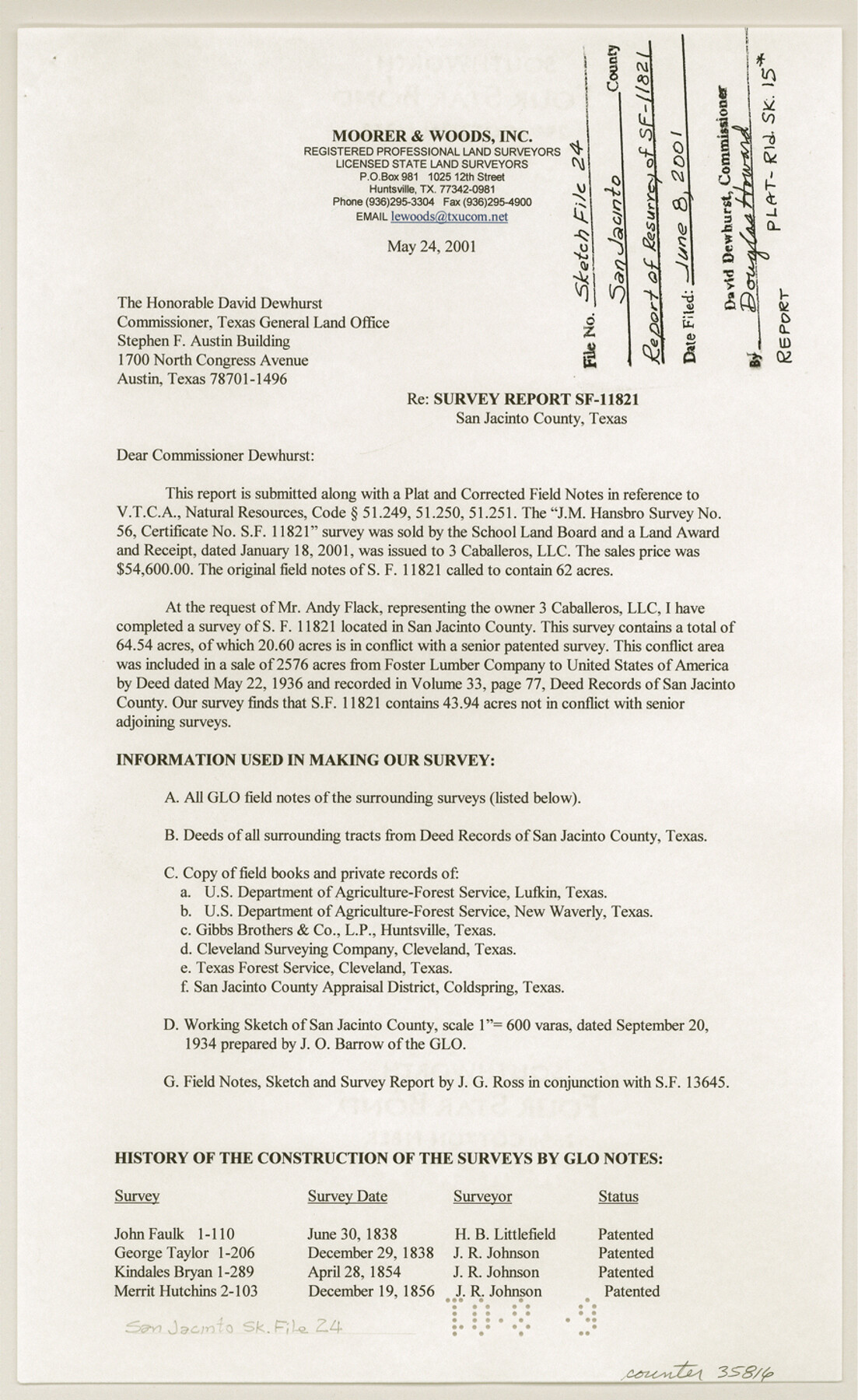
San Jacinto County Sketch File 24
[Survey report regarding SF-11821]
-
Map/Doc
35816
-
Collection
General Map Collection
-
Object Dates
5/24/2001 (Creation Date)
6/8/2001 (File Date)
-
People and Organizations
Leonard E. Woods (Surveyor/Engineer)
-
Counties
San Jacinto
-
Subjects
Surveying Sketch File
-
Height x Width
14.5 x 8.9 inches
36.8 x 22.6 cm
-
Medium
paper, print
-
Comments
See San Jacinto County Rolled Sketch 15 (7571) for sketch.
Related maps
San Jacinto County Rolled Sketch 15

Print $20.00
- Digital $50.00
San Jacinto County Rolled Sketch 15
2001
Size 19.2 x 25.2 inches
Map/Doc 7571
Part of: General Map Collection
Mills County Boundary File 3a

Print $48.00
- Digital $50.00
Mills County Boundary File 3a
Size 14.2 x 8.8 inches
Map/Doc 57287
Webb County Working Sketch 64

Print $20.00
- Digital $50.00
Webb County Working Sketch 64
1962
Size 12.8 x 26.1 inches
Map/Doc 72430
Harris County Rolled Sketch T2

Print $20.00
- Digital $50.00
Harris County Rolled Sketch T2
1916
Size 26.8 x 23.2 inches
Map/Doc 6145
Jefferson County NRC Article 33.136 Sketch 2

Print $20.00
- Digital $50.00
Jefferson County NRC Article 33.136 Sketch 2
2002
Size 24.3 x 35.9 inches
Map/Doc 77048
Kuechler's Corners, Texas & Pacific Ry. Co. 80 Mile Reserve

Print $703.00
- Digital $50.00
Kuechler's Corners, Texas & Pacific Ry. Co. 80 Mile Reserve
1934
Size 11.0 x 8.5 inches
Map/Doc 2248
Hardin County Rolled Sketch 11

Print $20.00
- Digital $50.00
Hardin County Rolled Sketch 11
1948
Size 20.8 x 38.6 inches
Map/Doc 6083
Terrell County Working Sketch 46

Print $20.00
- Digital $50.00
Terrell County Working Sketch 46
1958
Size 23.8 x 23.4 inches
Map/Doc 62139
Brazoria County NRC Article 33.136 Sketch 34

Print $24.00
Brazoria County NRC Article 33.136 Sketch 34
2025
Map/Doc 97478
Chambers County NRC Article 33.136 Location Key Sheet

Print $20.00
- Digital $50.00
Chambers County NRC Article 33.136 Location Key Sheet
1983
Size 24.0 x 44.0 inches
Map/Doc 77014
Hutchinson County Working Sketch Graphic Index - sheet 2

Print $20.00
- Digital $50.00
Hutchinson County Working Sketch Graphic Index - sheet 2
1922
Size 43.8 x 36.7 inches
Map/Doc 76587
Lee County Working Sketch 7

Print $20.00
- Digital $50.00
Lee County Working Sketch 7
1977
Size 27.0 x 16.8 inches
Map/Doc 70386
Bandera County Sketch File 35

Print $2.00
- Digital $50.00
Bandera County Sketch File 35
Size 11.2 x 8.7 inches
Map/Doc 14033
You may also like
El Paso County Sketch File 38

Print $4.00
- Digital $50.00
El Paso County Sketch File 38
1987
Size 14.3 x 8.9 inches
Map/Doc 22223
Walker County Sketch File 5

Print $4.00
- Digital $50.00
Walker County Sketch File 5
Size 13.5 x 8.3 inches
Map/Doc 39555
Map of the route of B'vt. Maj. A. Moore's scout, April 11th to June 12th 1869

Print $20.00
Map of the route of B'vt. Maj. A. Moore's scout, April 11th to June 12th 1869
1872
Size 23.6 x 40.9 inches
Map/Doc 93566
Briscoe County Sketch File J

Print $40.00
- Digital $50.00
Briscoe County Sketch File J
1919
Size 19.3 x 32.0 inches
Map/Doc 11007
Nueces County Sketch File 26a

Print $14.00
- Digital $50.00
Nueces County Sketch File 26a
1894
Size 12.6 x 7.9 inches
Map/Doc 32581

Harrison County Sketch File 23

Print $125.00
- Digital $50.00
Harrison County Sketch File 23
Size 10.6 x 12.2 inches
Map/Doc 26061
Calhoun County NRC Article 33.136 Sketch 2

Print $20.00
- Digital $50.00
Calhoun County NRC Article 33.136 Sketch 2
2002
Size 18.2 x 24.6 inches
Map/Doc 78653
Brewster County Rolled Sketch 69

Print $20.00
- Digital $50.00
Brewster County Rolled Sketch 69
1940
Size 17.0 x 15.7 inches
Map/Doc 5235
Freestone County Sketch File 4

Print $6.00
- Digital $50.00
Freestone County Sketch File 4
1848
Size 10.8 x 8.2 inches
Map/Doc 23044
Topographic Map of Big Bend Area

Print $20.00
Topographic Map of Big Bend Area
1923
Size 47.1 x 35.0 inches
Map/Doc 79757
Andrews County Rolled Sketch 15

Print $20.00
- Digital $50.00
Andrews County Rolled Sketch 15
1934
Size 27.9 x 22.4 inches
Map/Doc 77166