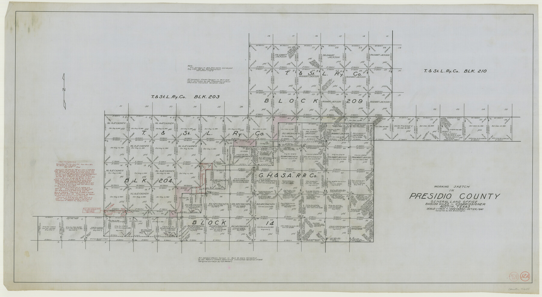
Presidio County Working Sketch 12a
-
Map/Doc
71688
-
Collection
General Map Collection
-
Object Dates
10/28/1941 (Creation Date)
-
People and Organizations
W. S. Brewington (Compiler)
-
Counties
Presidio
-
Subjects
Surveying Working Sketch
-
Height x Width
23.7 x 43.1 inches
60.2 x 109.5 cm
-
Scale
1" = 1000 varas
Part of: General Map Collection
Gaines County Working Sketch 15

Print $40.00
- Digital $50.00
Gaines County Working Sketch 15
1958
Size 66.3 x 34.0 inches
Map/Doc 69315
Leon County Sketch File 22

Print $24.00
- Digital $50.00
Leon County Sketch File 22
Size 12.8 x 8.8 inches
Map/Doc 29772
Clay County Boundary File 15

Print $8.00
- Digital $50.00
Clay County Boundary File 15
Size 13.3 x 8.2 inches
Map/Doc 51418
Map of Madison County

Print $20.00
- Digital $50.00
Map of Madison County
1880
Size 17.0 x 24.9 inches
Map/Doc 3832
Flight Mission No. DCL-5C, Frame 4, Kenedy County

Print $20.00
- Digital $50.00
Flight Mission No. DCL-5C, Frame 4, Kenedy County
1943
Size 18.6 x 22.5 inches
Map/Doc 85829
Hunt County Rolled Sketch 5

Print $20.00
- Digital $50.00
Hunt County Rolled Sketch 5
1966
Size 24.7 x 24.5 inches
Map/Doc 6275
Polk County Rolled Sketch 27

Print $20.00
- Digital $50.00
Polk County Rolled Sketch 27
1944
Size 21.1 x 26.6 inches
Map/Doc 7315
![94159, Austin Street Map [Verso], General Map Collection](https://historictexasmaps.com/wmedia_w700/maps/94159.tif.jpg)
Clay County Boundary File 16

Print $56.00
- Digital $50.00
Clay County Boundary File 16
Size 9.1 x 3.7 inches
Map/Doc 51422
Maps of the new and popular St. Louis and Texas Short Line composed of the St. Louis, Iron Mountain & Southern, Texas & Pacific and International & Great Northern Railways

Print $20.00
- Digital $50.00
Maps of the new and popular St. Louis and Texas Short Line composed of the St. Louis, Iron Mountain & Southern, Texas & Pacific and International & Great Northern Railways
1874
Size 19.0 x 32.0 inches
Map/Doc 93638
Panola County Rolled Sketch 2

Print $20.00
- Digital $50.00
Panola County Rolled Sketch 2
1944
Size 20.7 x 27.0 inches
Map/Doc 7197
Ochiltree County

Print $20.00
- Digital $50.00
Ochiltree County
1878
Size 19.2 x 17.5 inches
Map/Doc 3924
You may also like

Aransas County Sketch File 7

Print $4.00
- Digital $50.00
Aransas County Sketch File 7
Size 12.7 x 7.9 inches
Map/Doc 13112
Flight Mission No. DQN-6K, Frame 4, Calhoun County

Print $20.00
- Digital $50.00
Flight Mission No. DQN-6K, Frame 4, Calhoun County
1953
Size 18.4 x 22.1 inches
Map/Doc 84426
[8 Ranch, Kent County, Texas]
![91032, [8 Ranch, Kent County, Texas], Twichell Survey Records](https://historictexasmaps.com/wmedia_w700/maps/91032-1.tif.jpg)
Print $20.00
- Digital $50.00
[8 Ranch, Kent County, Texas]
1946
Size 21.4 x 37.4 inches
Map/Doc 91032

Sterling County Rolled Sketch 34

Print $20.00
- Digital $50.00
Sterling County Rolled Sketch 34
1960
Size 16.0 x 21.8 inches
Map/Doc 7858
Montgomery County Working Sketch 64

Print $20.00
- Digital $50.00
Montgomery County Working Sketch 64
1965
Size 27.9 x 33.7 inches
Map/Doc 71171
La Salle County Working Sketch 38

Print $20.00
- Digital $50.00
La Salle County Working Sketch 38
1961
Size 26.6 x 18.4 inches
Map/Doc 70339
Artesian Company Subdivision

Print $20.00
- Digital $50.00
Artesian Company Subdivision
1955
Size 12.0 x 15.8 inches
Map/Doc 92698
Bastrop County Working Sketch 2

Print $20.00
- Digital $50.00
Bastrop County Working Sketch 2
1913
Size 14.0 x 13.6 inches
Map/Doc 67302
Flight Mission No. CGI-4N, Frame 23, Cameron County

Print $20.00
- Digital $50.00
Flight Mission No. CGI-4N, Frame 23, Cameron County
1954
Size 18.6 x 22.4 inches
Map/Doc 84656
Lamb County Rolled Sketch 7

Print $20.00
- Digital $50.00
Lamb County Rolled Sketch 7
Size 45.6 x 26.3 inches
Map/Doc 9415