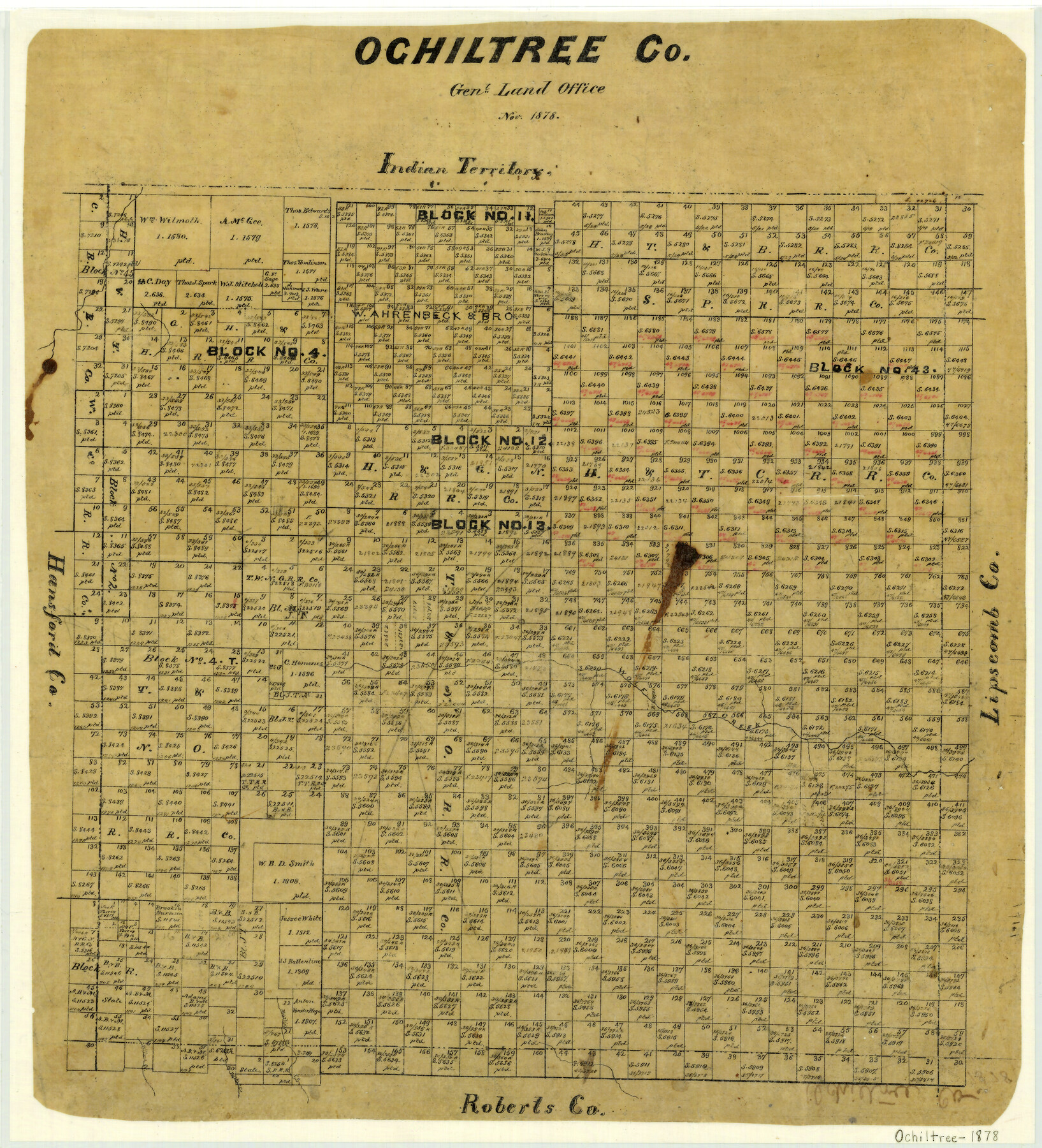
Ochiltree County
-
Map/Doc
3924
-
Collection
General Map Collection
-
Object Dates
1878 (Creation Date)
-
People and Organizations
Texas General Land Office (Publisher)
-
Counties
Ochiltree
-
Subjects
County
-
Height x Width
19.2 x 17.5 inches
48.8 x 44.5 cm
-
Features
Wolf Creek
Martin's Creek
Walker Creek
Willow Creek
Part of: General Map Collection
Limestone County Boundary File 1

Print $9.00
- Digital $50.00
Limestone County Boundary File 1
Size 8.8 x 14.5 inches
Map/Doc 56296
Flight Mission No. DAH-9M, Frame 155, Orange County

Print $20.00
- Digital $50.00
Flight Mission No. DAH-9M, Frame 155, Orange County
1953
Size 18.6 x 22.6 inches
Map/Doc 86854
Presidio County Sketch File 70a

Print $6.00
- Digital $50.00
Presidio County Sketch File 70a
1923
Size 17.0 x 11.0 inches
Map/Doc 34669
Reagan County Working Sketch 32

Print $20.00
- Digital $50.00
Reagan County Working Sketch 32
1965
Size 43.9 x 37.1 inches
Map/Doc 71874
Index for Texas Railroad ROW & track maps available on microfilm at THD & Archives and Records

Print $2.00
- Digital $50.00
Index for Texas Railroad ROW & track maps available on microfilm at THD & Archives and Records
1977
Size 11.2 x 8.6 inches
Map/Doc 60759
Flight Mission No. CRK-8P, Frame 103, Refugio County

Print $20.00
- Digital $50.00
Flight Mission No. CRK-8P, Frame 103, Refugio County
1956
Size 18.4 x 22.1 inches
Map/Doc 86964
Cottle County Working Sketch 6

Print $20.00
- Digital $50.00
Cottle County Working Sketch 6
1927
Size 23.0 x 29.3 inches
Map/Doc 68316
Runnels County Working Sketch 14

Print $20.00
- Digital $50.00
Runnels County Working Sketch 14
1950
Size 28.4 x 26.8 inches
Map/Doc 63610
Montague County Working Sketch 24

Print $20.00
- Digital $50.00
Montague County Working Sketch 24
1953
Size 21.9 x 27.6 inches
Map/Doc 71090
Upton County Rolled Sketch 21

Print $20.00
- Digital $50.00
Upton County Rolled Sketch 21
1939
Size 21.5 x 37.9 inches
Map/Doc 8072
Hartley County Rolled Sketch 7

Print $20.00
- Digital $50.00
Hartley County Rolled Sketch 7
1952
Size 24.2 x 27.4 inches
Map/Doc 6161
Kimble County Sketch File 34

Print $20.00
- Digital $50.00
Kimble County Sketch File 34
1963
Size 26.2 x 16.3 inches
Map/Doc 11931
You may also like

Webb County Sketch File 3

Print $8.00
- Digital $50.00
Webb County Sketch File 3
Size 9.8 x 9.3 inches
Map/Doc 39713
Harrison County

Print $20.00
- Digital $50.00
Harrison County
1857
Size 20.3 x 21.0 inches
Map/Doc 1116
Mexico und Centro-America

Print $20.00
Mexico und Centro-America
1841
Size 14.1 x 17.1 inches
Map/Doc 79732
Blanco County Working Sketch 29

Print $40.00
- Digital $50.00
Blanco County Working Sketch 29
1969
Size 52.4 x 33.4 inches
Map/Doc 67389
Jack County Sketch File 9a

Print $6.00
- Digital $50.00
Jack County Sketch File 9a
1857
Size 12.5 x 7.8 inches
Map/Doc 27522
Kerr County Working Sketch 25

Print $20.00
- Digital $50.00
Kerr County Working Sketch 25
Size 21.5 x 28.5 inches
Map/Doc 70056
[McK. & Williams No. 601 and surrounding surveys, Travis County]
![75553, [McK. & Williams No. 601 and surrounding surveys, Travis County], Maddox Collection](https://historictexasmaps.com/wmedia_w700/maps/75553.tif.jpg)
Print $3.00
- Digital $50.00
[McK. & Williams No. 601 and surrounding surveys, Travis County]
Size 16.3 x 10.7 inches
Map/Doc 75553
Mexico, California and Texas

Print $20.00
Mexico, California and Texas
1850
Size 11.1 x 15.0 inches
Map/Doc 82964
Castro County Sketch File 15

Print $4.00
- Digital $50.00
Castro County Sketch File 15
1978
Size 11.2 x 8.7 inches
Map/Doc 17511
Flight Mission No. CRK-5P, Frame 123, Refugio County

Print $20.00
- Digital $50.00
Flight Mission No. CRK-5P, Frame 123, Refugio County
1956
Size 18.4 x 22.1 inches
Map/Doc 86926
Menard County Rolled Sketch 10

Print $20.00
- Digital $50.00
Menard County Rolled Sketch 10
1955
Size 46.7 x 37.7 inches
Map/Doc 9511