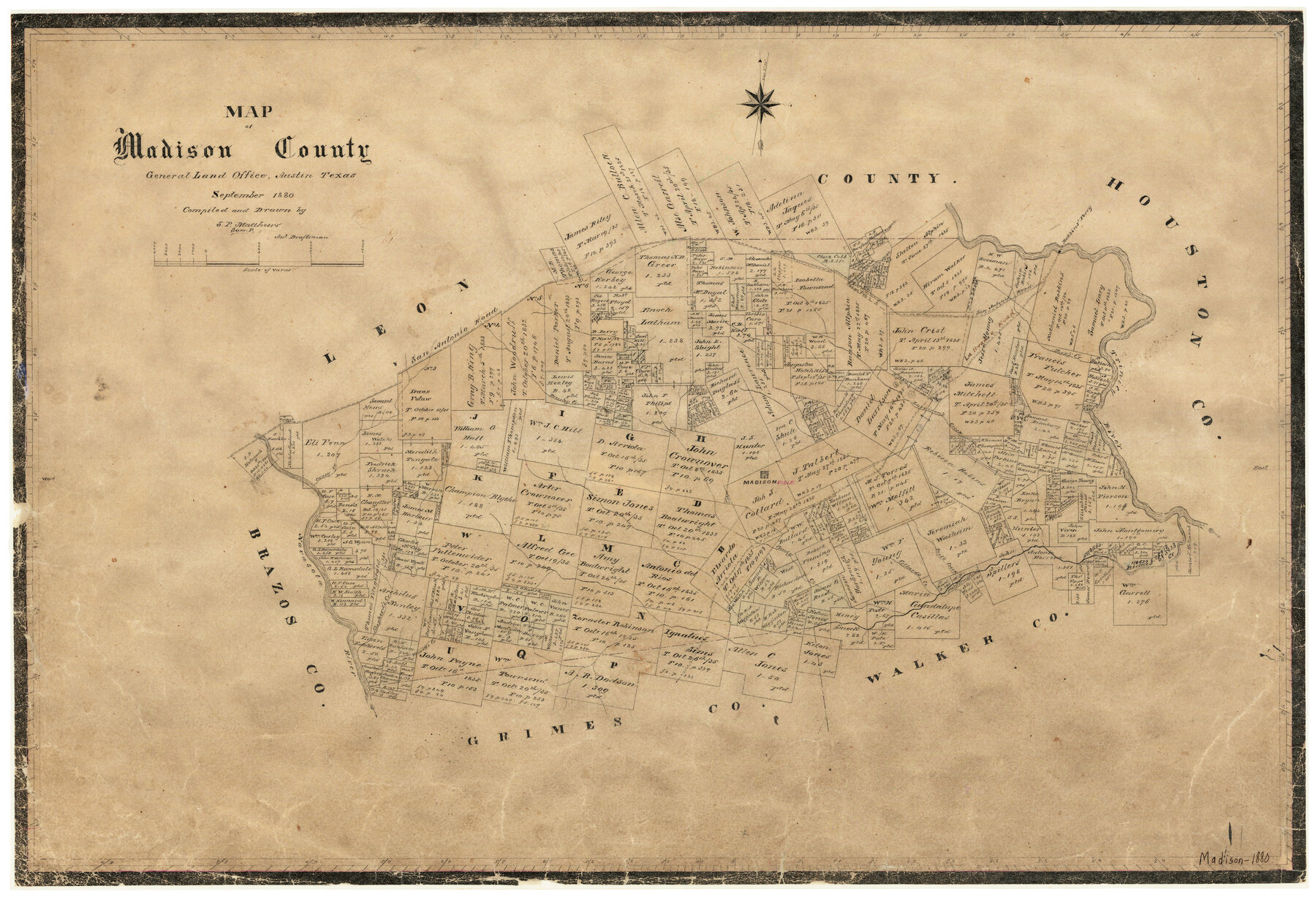
Map of Madison County
-
Map/Doc
3832
-
Collection
General Map Collection
-
Object Dates
9/1880 (Creation Date)
-
People and Organizations
Texas General Land Office (Publisher)
Sam. P. Matthews (Draftsman)
Sam. P. Matthews (Compiler)
-
Counties
Madison
-
Subjects
County
-
Height x Width
17.0 x 24.9 inches
43.2 x 63.3 cm
-
Features
Robbins' Ferry
San Antonio Road
La Bradie Road
Caney Creek
Brushy Creek
Madisonville
Larrison's Creek
Trinity River
Bidais Creek
Pool's Creek
Collards Creek
Navasota River
Shepherd's Creek
Prewitt's Creek
York's Creek
Part of: General Map Collection
Brewster County Working Sketch 83

Print $20.00
- Digital $50.00
Brewster County Working Sketch 83
1973
Size 43.6 x 41.1 inches
Map/Doc 67683
United States - Gulf Coast - From Latitude 26° 33' to the Rio Grande Texas

Print $20.00
- Digital $50.00
United States - Gulf Coast - From Latitude 26° 33' to the Rio Grande Texas
1918
Size 18.4 x 24.3 inches
Map/Doc 72846
Donley County Sketch File B8

Print $20.00
- Digital $50.00
Donley County Sketch File B8
1920
Size 15.3 x 15.9 inches
Map/Doc 11378
University Land Field Notes for Blocks 34 through 37 in Terrell County

University Land Field Notes for Blocks 34 through 37 in Terrell County
Map/Doc 81720
Edwards County Working Sketch 129

Print $20.00
- Digital $50.00
Edwards County Working Sketch 129
1981
Size 33.6 x 41.3 inches
Map/Doc 69005
Liberty County Boundary File 2

Print $9.00
- Digital $50.00
Liberty County Boundary File 2
Size 17.0 x 11.0 inches
Map/Doc 56293
Karnes County Rolled Sketch 1

Print $20.00
- Digital $50.00
Karnes County Rolled Sketch 1
1943
Size 27.5 x 25.7 inches
Map/Doc 6452
Palo Pinto County Rolled Sketch 8

Print $40.00
- Digital $50.00
Palo Pinto County Rolled Sketch 8
Size 116.4 x 54.6 inches
Map/Doc 9674
Gillespie County Sketch File 15

Print $20.00
- Digital $50.00
Gillespie County Sketch File 15
1847
Size 17.7 x 19.3 inches
Map/Doc 11556
Map of Deaf Smith Co.

Print $40.00
- Digital $50.00
Map of Deaf Smith Co.
1898
Size 42.5 x 54.6 inches
Map/Doc 16821
Garza County Rolled Sketch 6D

Print $20.00
- Digital $50.00
Garza County Rolled Sketch 6D
1913
Size 17.4 x 16.0 inches
Map/Doc 5998
Kendall County Working Sketch 4

Print $20.00
- Digital $50.00
Kendall County Working Sketch 4
1946
Size 25.7 x 24.3 inches
Map/Doc 66676
You may also like
Brewster County Rolled Sketch 8

Print $40.00
- Digital $50.00
Brewster County Rolled Sketch 8
1878
Size 60.3 x 35.8 inches
Map/Doc 8467
Red River County Working Sketch 4

Print $20.00
- Digital $50.00
Red River County Working Sketch 4
1919
Size 19.7 x 18.8 inches
Map/Doc 71987
Williamson County Working Sketch 8

Print $20.00
- Digital $50.00
Williamson County Working Sketch 8
1950
Size 43.4 x 25.4 inches
Map/Doc 72568
Head of Cowhouse Cr.

Print $2.00
- Digital $50.00
Head of Cowhouse Cr.
1846
Size 6.4 x 13.7 inches
Map/Doc 271
Hockley County Sketch Mineral Application Number 38245

Print $20.00
- Digital $50.00
Hockley County Sketch Mineral Application Number 38245
1946
Size 40.6 x 18.5 inches
Map/Doc 92243
Wichita County Working Sketch 19

Print $20.00
- Digital $50.00
Wichita County Working Sketch 19
1949
Size 18.1 x 30.9 inches
Map/Doc 72529
[Surveys in the Liberty District in Tyler and Polk Counties]
![331, [Surveys in the Liberty District in Tyler and Polk Counties], General Map Collection](https://historictexasmaps.com/wmedia_w700/maps/331.tif.jpg)
Print $2.00
- Digital $50.00
[Surveys in the Liberty District in Tyler and Polk Counties]
1847
Size 5.9 x 8.4 inches
Map/Doc 331
Flight Mission No. DCL-6C, Frame 115, Kenedy County

Print $20.00
- Digital $50.00
Flight Mission No. DCL-6C, Frame 115, Kenedy County
1943
Size 18.5 x 22.4 inches
Map/Doc 85945
Harris County Aerial Photograph Index Sheet 8

Print $20.00
- Digital $50.00
Harris County Aerial Photograph Index Sheet 8
1953
Size 22.2 x 16.8 inches
Map/Doc 83702
Briscoe County Sketch File 2a

Print $4.00
- Digital $50.00
Briscoe County Sketch File 2a
Size 6.2 x 7.1 inches
Map/Doc 16415
Kinney County Sketch File 32

Print $6.00
- Digital $50.00
Kinney County Sketch File 32
1934
Size 11.2 x 8.8 inches
Map/Doc 29178
Working Sketch Cottle County

Print $20.00
- Digital $50.00
Working Sketch Cottle County
1916
Size 31.7 x 29.6 inches
Map/Doc 4434