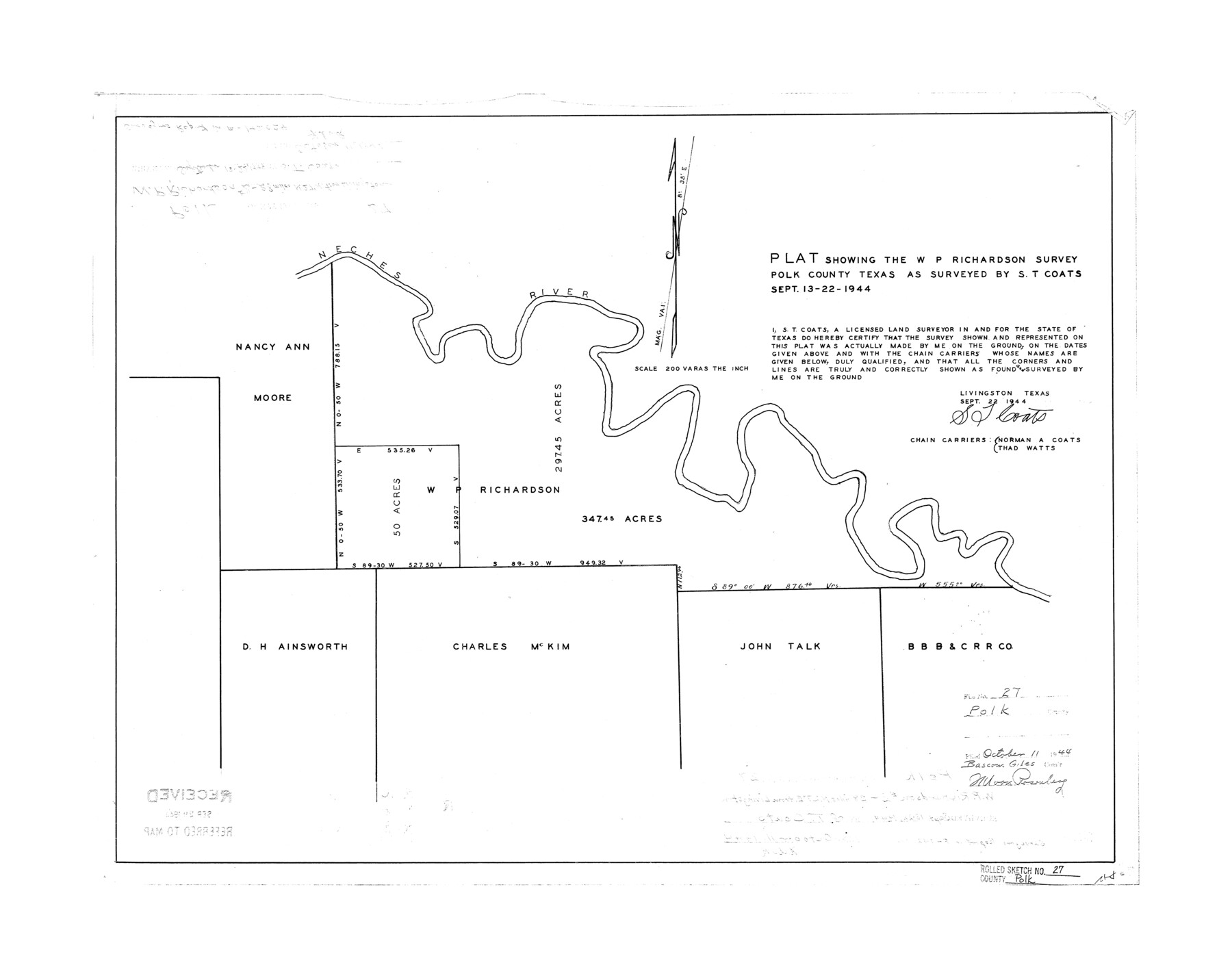
Polk County Rolled Sketch 27
Plat showing the W.P. Richardson survey
- 
                          Map/Doc
7315
 - 
                            Collection
General Map Collection
 - 
                            Object Dates
1944/9/22 (Creation Date)
1944/10/11 (File Date)
 - 
                            People and Organizations
S.T. Coats (Surveyor/Engineer)
Norman A. Coats (Chainman/Field Personnel)
Thad Watts (Chainman/Field Personnel)
 - 
                            Counties
Polk
 - 
                            Subjects
Surveying Rolled Sketch
 - 
                            Height x Width
21.1 x 26.6 inches
53.6 x 67.6 cm
 - 
                            Scale
1" = 200 varas
 
Part of: General Map Collection
            Orange County Working Sketch 12


                                            Print $20.00                    
                                             -                         Digital $50.00                                    
                Orange County Working Sketch 12
1922
Size 17.2 x 12.7 inches
                                Map/Doc 71344
            
            Dickens County Sketch File N


                                            Print $4.00                    
                                             -                         Digital $50.00                                    
                Dickens County Sketch File N
1903
Size 8.3 x 13.6 inches
                                Map/Doc 20942
            
            Cooke County Rolled Sketch 1


                                            Print $20.00                    
                                             -                         Digital $50.00                                    
                Cooke County Rolled Sketch 1
1940
Size 26.2 x 15.8 inches
                                Map/Doc 5560
            
            Reeves County


                                            Print $40.00                    
                                             -                         Digital $50.00                                    
                Reeves County
1915
Size 48.4 x 38.7 inches
                                Map/Doc 66999
            
            Map of Lake Travis with detailed maps of Lakeway, Briarcliff, Lago Vista, Highland Lake Estates


            Map of Lake Travis with detailed maps of Lakeway, Briarcliff, Lago Vista, Highland Lake Estates
Size 23.0 x 35.2 inches
                                Map/Doc 94373
            
            Bosque County Sketch File 29


                                            Print $6.00                    
                                             -                         Digital $50.00                                    
                Bosque County Sketch File 29
1863
Size 12.9 x 8.1 inches
                                Map/Doc 14816
            
            Lamar County Sketch File 5


                                            Print $4.00                    
                                             -                         Digital $50.00                                    
                Lamar County Sketch File 5
1877
Size 4.8 x 8.1 inches
                                Map/Doc 29284
            
            Flight Mission No. CLL-1N, Frame 33, Willacy County


                                            Print $20.00                    
                                             -                         Digital $50.00                                    
                Flight Mission No. CLL-1N, Frame 33, Willacy County
1954
Size 18.4 x 22.1 inches
                                Map/Doc 87014
            
            Brooks County Working Sketch 8


                                            Print $20.00                    
                                             -                         Digital $50.00                                    
                Brooks County Working Sketch 8
1928
Size 27.6 x 23.3 inches
                                Map/Doc 67792
            
            Flight Mission No. DCL-7C, Frame 116, Kenedy County


                                            Print $20.00                    
                                             -                         Digital $50.00                                    
                Flight Mission No. DCL-7C, Frame 116, Kenedy County
1943
Size 18.6 x 22.4 inches
                                Map/Doc 86081
            
            Brazos River Entrance


                                            Print $20.00                    
                                             -                         Digital $50.00                                    
                Brazos River Entrance
1925
Size 31.0 x 41.4 inches
                                Map/Doc 69974
            
            Le Nouveau Mexique avec la partie Septentrionale de l'Ancien ou de la Nouvelle Espagne


                                            Print $20.00                    
                                             -                         Digital $50.00                                    
                Le Nouveau Mexique avec la partie Septentrionale de l'Ancien ou de la Nouvelle Espagne
1780
Size 10.0 x 14.4 inches
                                Map/Doc 97277
            You may also like
            Matagorda County NRC Article 33.136 Sketch 7


                                            Print $24.00                    
                                             -                         Digital $50.00                                    
                Matagorda County NRC Article 33.136 Sketch 7
2010
Size 24.0 x 36.0 inches
                                Map/Doc 89997
            
            [County table portion of 1879 State of Texas map by Pressler & Langermann]


                                            Print $20.00                    
                                             -                         Digital $50.00                                    
                [County table portion of 1879 State of Texas map by Pressler & Langermann]
1879
Size 15.0 x 23.6 inches
                                Map/Doc 3102
            
            Sabine County Working Sketch 8


                                            Print $20.00                    
                                             -                         Digital $50.00                                    
                Sabine County Working Sketch 8
1923
Size 40.8 x 43.5 inches
                                Map/Doc 63679
            
            El Paso County Working Sketch 24


                                            Print $20.00                    
                                             -                         Digital $50.00                                    
                El Paso County Working Sketch 24
1961
Size 26.4 x 22.0 inches
                                Map/Doc 69046
            
            Nueces River, Bluntzer Sheet


                                            Print $20.00                    
                                             -                         Digital $50.00                                    
                Nueces River, Bluntzer Sheet
1927
Size 35.3 x 42.9 inches
                                Map/Doc 65088
            
            Flight Mission No. CGI-1N, Frame 179, Cameron County


                                            Print $20.00                    
                                             -                         Digital $50.00                                    
                Flight Mission No. CGI-1N, Frame 179, Cameron County
1955
Size 18.5 x 22.2 inches
                                Map/Doc 84514
            
            Burnet County Working Sketch 17


                                            Print $20.00                    
                                             -                         Digital $50.00                                    
                Burnet County Working Sketch 17
1979
Size 41.1 x 34.4 inches
                                Map/Doc 67860
            
            [Surveys along the San Antonio and Cibolo Rivers]


                                            Print $20.00                    
                                             -                         Digital $50.00                                    
                [Surveys along the San Antonio and Cibolo Rivers]
Size 16.9 x 20.2 inches
                                Map/Doc 69
            
            Crane County Rolled Sketch 7


                                            Print $20.00                    
                                             -                         Digital $50.00                                    
                Crane County Rolled Sketch 7
1927
Size 33.4 x 44.8 inches
                                Map/Doc 8679
            
            Jackson County Sketch File 2


                                            Print $6.00                    
                                             -                         Digital $50.00                                    
                Jackson County Sketch File 2
Size 10.2 x 15.5 inches
                                Map/Doc 27619
            
            Milam County Rolled Sketch 3C


                                            Print $20.00                    
                                             -                         Digital $50.00                                    
                Milam County Rolled Sketch 3C
1959
Size 21.8 x 18.4 inches
                                Map/Doc 6776
            
            Map of the Texas & Pacific Railway Company Reserve west of the Colorado River


                                            Print $40.00                    
                                             -                         Digital $50.00                                    
                Map of the Texas & Pacific Railway Company Reserve west of the Colorado River
1877
Size 48.9 x 59.2 inches
                                Map/Doc 2233