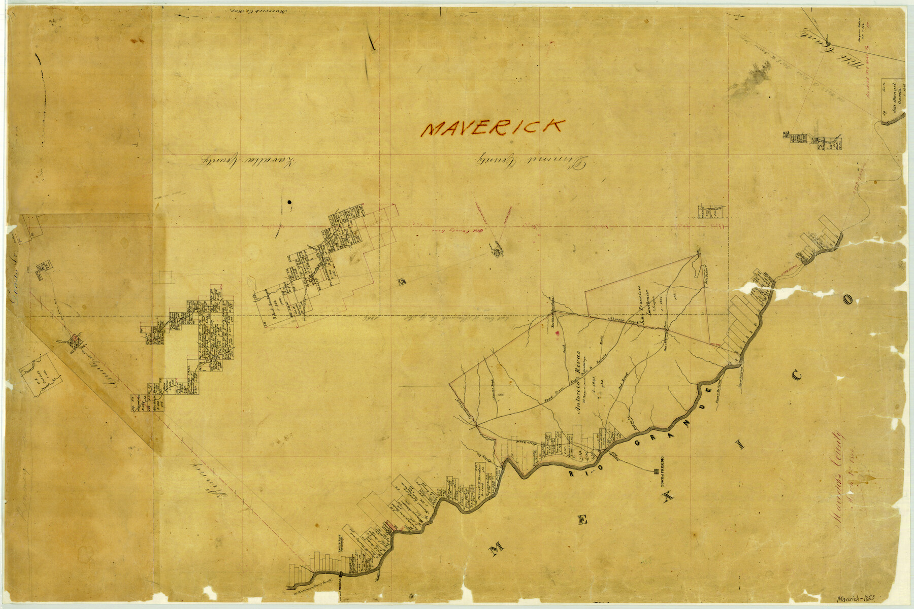
Maverick County
-
Map/Doc
3847
-
Collection
General Map Collection
-
Object Dates
1863/3/1 (Creation Date)
-
People and Organizations
Texas General Land Office (Publisher)
-
Counties
Maverick
-
Subjects
County
-
Height x Width
24.4 x 36.6 inches
62.0 x 93.0 cm
-
Features
Paquache Pass
Tape Lake
Tape Lake [Road]
Chaparosa Creek
Eagle Pass and San Antonio Road
Presidio Road
Mueba Creek
Wall's Road
Nueces Road
Cuevas Creek
Willow Creek
San Antonio Road
Cuero Creek
Town of Presidio
Rio Grande
Upper Pañitas [Creek]
Lower Pañitas [Creek]
Eagle Pass
Fort Duncan
Piedras Negras
Rio Escondido
Trail [from Abrosia Creek to Road from Eagle Pass to Laredo]
Live Oak Creek
San Lorenzo Creek
Las Muetas Creek
Saint Mary's Creek
Smith's Creek
Pena Creek
Presidio Reseco Creek
San Pedro Creek
San Antonio Pass
Abrosia [sic] Creek
Los Dos Hermanos [Mountains]
Old Road [to San Ambrosia Pass]
Road to [Rositas of San Juan]
Road from Eagle Pass to Laredo
Eagle Pass Road
Laredo Road
San Ambrosia Pass
Mustang Creek
Elm Creek
General Woll's Road
Part of: General Map Collection
Travis County Appraisal District Plat Map 2_0404

Print $20.00
- Digital $50.00
Travis County Appraisal District Plat Map 2_0404
Size 21.5 x 26.4 inches
Map/Doc 94229
El Paso County Rolled Sketch RJ

Print $40.00
- Digital $50.00
El Paso County Rolled Sketch RJ
1919
Size 56.7 x 27.2 inches
Map/Doc 8865
San Patricio County Rolled Sketch 46C

Print $3.00
- Digital $50.00
San Patricio County Rolled Sketch 46C
1983
Size 11.0 x 17.5 inches
Map/Doc 8374
Flight Mission No. DAG-16K, Frame 72, Matagorda County

Print $20.00
- Digital $50.00
Flight Mission No. DAG-16K, Frame 72, Matagorda County
1952
Size 16.5 x 16.4 inches
Map/Doc 86318
Nolan County Sketch File 1a

Print $20.00
- Digital $50.00
Nolan County Sketch File 1a
1882
Size 20.7 x 39.4 inches
Map/Doc 10554
[Center Line of the Texas and Pacific Railroad Company 16 Mile Reserve]
![3125, [Center Line of the Texas and Pacific Railroad Company 16 Mile Reserve], General Map Collection](https://historictexasmaps.com/wmedia_w700/maps/3125-1.tif.jpg)
Print $40.00
- Digital $50.00
[Center Line of the Texas and Pacific Railroad Company 16 Mile Reserve]
1876
Size 43.1 x 55.6 inches
Map/Doc 3125
Map representing the surveys made in Bexar County

Print $40.00
- Digital $50.00
Map representing the surveys made in Bexar County
1839
Size 76.0 x 68.4 inches
Map/Doc 1947
[Map of Val Verde County]
![4110, [Map of Val Verde County], General Map Collection](https://historictexasmaps.com/wmedia_w700/maps/4110-1.tif.jpg)
Print $20.00
- Digital $50.00
[Map of Val Verde County]
1931
Size 36.4 x 24.1 inches
Map/Doc 4110

Flight Mission No. DIX-6P, Frame 182, Aransas County

Print $20.00
- Digital $50.00
Flight Mission No. DIX-6P, Frame 182, Aransas County
1956
Size 19.1 x 22.8 inches
Map/Doc 83844
Plat of Resurvey of Sections 5, 7 and 8, T. 5S., R. 14W. Indian Meridian, Oklahoma

Print $4.00
- Digital $50.00
Plat of Resurvey of Sections 5, 7 and 8, T. 5S., R. 14W. Indian Meridian, Oklahoma
1917
Size 18.5 x 22.6 inches
Map/Doc 75140
Castro County Sketch File 6

Print $20.00
- Digital $50.00
Castro County Sketch File 6
Size 20.8 x 15.6 inches
Map/Doc 11059
You may also like
Map of South America designed to accompany Smith's Geography of Schools

Print $20.00
- Digital $50.00
Map of South America designed to accompany Smith's Geography of Schools
1850
Size 12.0 x 9.8 inches
Map/Doc 93891
Aransas County Rolled Sketch 15B

Print $20.00
- Digital $50.00
Aransas County Rolled Sketch 15B
Size 19.0 x 19.8 inches
Map/Doc 76066
Flight Mission No. CGI-1N, Frame 184, Cameron County

Print $20.00
- Digital $50.00
Flight Mission No. CGI-1N, Frame 184, Cameron County
1955
Size 18.5 x 22.2 inches
Map/Doc 84519
San Patricio County Sketch File 31

Print $6.00
- Digital $50.00
San Patricio County Sketch File 31
Size 14.0 x 10.0 inches
Map/Doc 36117
Wise County Working Sketch 24

Print $40.00
- Digital $50.00
Wise County Working Sketch 24
1983
Size 37.1 x 58.2 inches
Map/Doc 72638
Stonewall County Boundary File 1

Print $34.00
- Digital $50.00
Stonewall County Boundary File 1
Size 9.0 x 8.4 inches
Map/Doc 58938
General Highway Map, Duval County, Texas

Print $20.00
General Highway Map, Duval County, Texas
1961
Size 18.1 x 24.5 inches
Map/Doc 79449
Kaufman County

Print $20.00
- Digital $50.00
Kaufman County
1942
Size 46.6 x 38.2 inches
Map/Doc 1871
East Part of Brewster Co.

Print $40.00
- Digital $50.00
East Part of Brewster Co.
1952
Size 49.5 x 31.1 inches
Map/Doc 95436
Map showing surveys in Blocks 45, 3, R & 5T

Print $20.00
- Digital $50.00
Map showing surveys in Blocks 45, 3, R & 5T
1913
Size 30.2 x 37.5 inches
Map/Doc 496
Anderson County Sketch File 1

Print $4.00
- Digital $50.00
Anderson County Sketch File 1
1845
Size 12.5 x 8.3 inches
Map/Doc 12737
Grayson County Working Sketch 10

Print $20.00
- Digital $50.00
Grayson County Working Sketch 10
1951
Size 41.6 x 37.8 inches
Map/Doc 63249