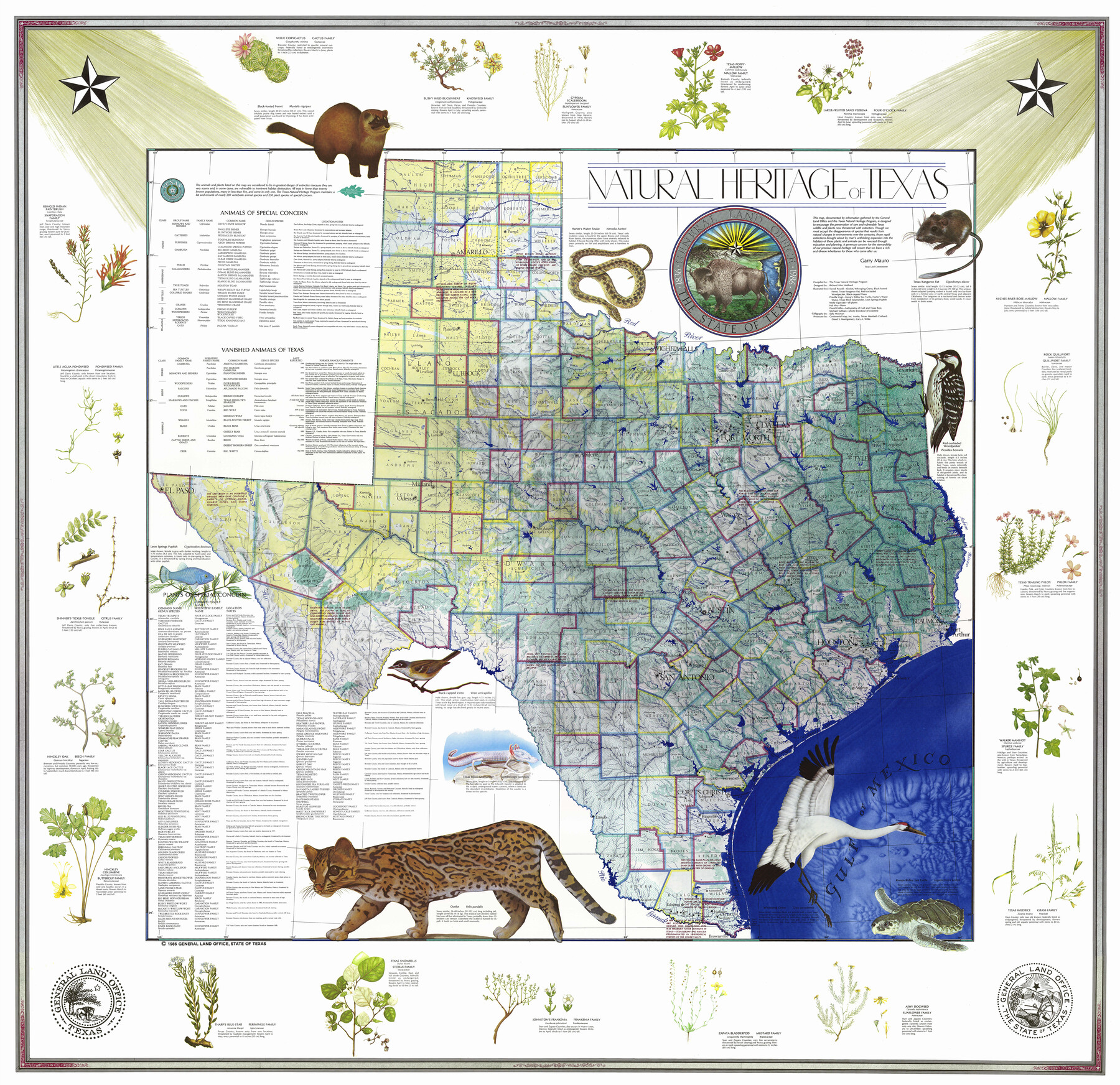
Natural Heritage of Texas
-
Map/Doc
10786
-
Collection
General Map Collection
-
Object Dates
1986 (Creation Date)
-
People and Organizations
General Land Office (Publisher)
Garry Mauro (GLO Commissioner)
The Texas Natural Heritage Program (Compiler)
Richard Alan Hubbard (Cartographer)
Terrell Powell (Illustrator)
Priscilla Vogt (Illustrator)
Molly Ogorzaly (Illustrator)
Hal Irby (Illustrator)
David Griffin (Illustrator)
Michael Sullivan (Illustrator)
Sally Hickman (Letterer)
David S. Montgomery (Producer)
Cary A. Wilke (Producer)
Merideth Gothard (Producer)
-
Subjects
Pictorial State of Texas
-
Height x Width
54.3 x 56.0 inches
137.9 x 142.2 cm
-
Medium
paper, etching/engraving/lithograph
-
URLs
https://medium.com/@txglo/my-favorite-map-the-natural-heritage-map-of-texas-1986-53861aac4ea0#.yf8czbig4
Part of: General Map Collection
Hudspeth County Working Sketch 41

Print $20.00
- Digital $50.00
Hudspeth County Working Sketch 41
1981
Size 18.3 x 37.1 inches
Map/Doc 66326
Baylor County Sketch File 13

Print $4.00
- Digital $50.00
Baylor County Sketch File 13
1856
Size 13.5 x 8.5 inches
Map/Doc 14179
Coleman County Working Sketch 3

Print $20.00
- Digital $50.00
Coleman County Working Sketch 3
1918
Size 27.1 x 29.2 inches
Map/Doc 68069
[Blocks 341, G-5, G-12, TCRRCo.]
![60298, [Blocks 341, G-5, G-12, TCRRCo.], General Map Collection](https://historictexasmaps.com/wmedia_w700/maps/60298-1.tif.jpg)
Print $20.00
- Digital $50.00
[Blocks 341, G-5, G-12, TCRRCo.]
1954
Size 15.1 x 26.1 inches
Map/Doc 60298
Lee County Working Sketch 14

Print $20.00
- Digital $50.00
Lee County Working Sketch 14
1981
Size 17.9 x 11.4 inches
Map/Doc 70393
Kerr County Rolled Sketch 16

Print $20.00
- Digital $50.00
Kerr County Rolled Sketch 16
1951
Size 40.6 x 31.1 inches
Map/Doc 9346
Flight Mission No. DAG-28K, Frame 30, Matagorda County

Print $20.00
- Digital $50.00
Flight Mission No. DAG-28K, Frame 30, Matagorda County
1953
Size 16.1 x 16.1 inches
Map/Doc 86598
Brewster County Sketch File NS-4a

Print $13.00
- Digital $50.00
Brewster County Sketch File NS-4a
Size 9.3 x 14.2 inches
Map/Doc 15953
Presidio County

Print $40.00
- Digital $50.00
Presidio County
1875
Size 97.8 x 33.5 inches
Map/Doc 88867
Map of north end of Brazos Island

Print $20.00
- Digital $50.00
Map of north end of Brazos Island
Size 27.6 x 18.2 inches
Map/Doc 72908
Map of Great Britain and Ireland engraved to illustrate Mitchell's new intermediate geography

Print $20.00
- Digital $50.00
Map of Great Britain and Ireland engraved to illustrate Mitchell's new intermediate geography
1885
Size 12.2 x 9.0 inches
Map/Doc 93527
Medina County Working Sketch 4

Print $40.00
- Digital $50.00
Medina County Working Sketch 4
1945
Size 52.6 x 35.5 inches
Map/Doc 70919
You may also like
General Highway Map, Swisher County, Texas

Print $20.00
General Highway Map, Swisher County, Texas
1940
Size 18.4 x 25.0 inches
Map/Doc 79250
Jefferson County Aerial Photograph Index Sheet 6

Print $20.00
- Digital $50.00
Jefferson County Aerial Photograph Index Sheet 6
1953
Size 23.3 x 17.0 inches
Map/Doc 83710
Titus County Working Sketch 3

Print $20.00
- Digital $50.00
Titus County Working Sketch 3
Size 21.7 x 31.8 inches
Map/Doc 69364
Briscoe County Working Sketch 5

Print $20.00
- Digital $50.00
Briscoe County Working Sketch 5
1934
Size 36.7 x 43.0 inches
Map/Doc 67808
Gulf Intracoastal Waterway - Texas Erosion at the West End of Bolivar Peninsula Comparative Shorelines

Print $20.00
- Digital $50.00
Gulf Intracoastal Waterway - Texas Erosion at the West End of Bolivar Peninsula Comparative Shorelines
1950
Size 29.0 x 40.3 inches
Map/Doc 61826
Chambers County Sketch File 56

Print $7.00
- Digital $50.00
Chambers County Sketch File 56
Size 14.8 x 8.7 inches
Map/Doc 18099


Greer County Sketch File 12

Print $20.00
- Digital $50.00
Greer County Sketch File 12
Size 23.6 x 20.1 inches
Map/Doc 11585
Map of Texas from the most recent authorities

Print $20.00
Map of Texas from the most recent authorities
1845
Size 13.5 x 17.1 inches
Map/Doc 94574
Brewster County Sketch File C-1

Print $14.00
- Digital $50.00
Brewster County Sketch File C-1
1911
Size 11.2 x 8.9 inches
Map/Doc 15719
